At Midday, Mostly Cloudy Throughout Much Of Central Alabama
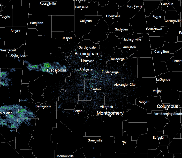
At the noon hour across Central Alabama, we have clouds moving in over much of the area that are from Tropical Storm Harvey. There are a few reflections showing up on radar mainly over the western part of the area, but most of these are evaporating before reaching the ground due to a thick dry layer just above the surface.
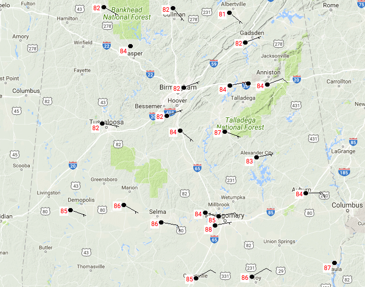
Temperatures are currently in the lower to mid-80s across the area with the exception of Eufaula which is at 87 degrees. Birmingham is currently at 82 degrees.
Weather For The Rest Of Today
Skies will continue to be partly to mostly cloudy throughout the afternoon and early evening hours, with a few sprinkles possible for the southwestern quarter of Central Alabama. Afternoon highs will be in the mid-80s to 90 degrees throughout the area. Later this evening and into the overnight hours, skies will be mostly cloudy but any sprinkles will have dissipated at this time. Overnight lows will be in the upper 60s to the lower 70s.
Next Week And Into Saturday
The forecast for much of the work week is still really up for grabs as we wait to see what will happen with Harvey. For now it looks like the rain chances will slowly increase throughout the week. Monday will have a small chance of isolated showers and storms for the extreme western locations in Central Alabama, while the rest stays dry. Tuesday through Saturday will feature a chance of scattered showers and storms each day, starting off at 1-in-5 odds of any one location getting rain on Tuesday and reaching near 50/50 odds by the end of the week. Highs throughout the week will be in the mid to upper 80s. Of course, this may all change if Harvey gets picked up by a cold front that will be approaching the area late in the week.

Harvey Continues To Weaken But Producing Biblical-Type Flooding
Harvey has weakened to a weak tropical storm as far as winds, but the continuous heavy rainfall is still prominent over the east-central parts of Texas. Looking at a few Twitter feeds from this morning, flood waters in the city of Houston are up to 17 feet deep in places. KHOU News in Houston had to evacuate their station due to rapidly rising water inside. As of 20 minutes ago, there have been nearly 2,000 high-water rescues since the rains have started from Harvey in Harris County alone, as reported by Harris County Sheriff’s Office.
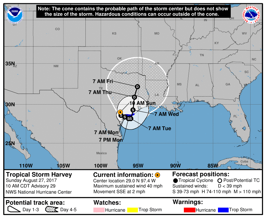
Unfortunately, Harvey looks to continue to hang over the eastern parts of Texas through Friday morning, even with a possible re-emergence over the Gulf of Mexico Monday night and into Tuesday morning before making landfall again and moving northward. Bottom line: more rain will continue to fall over already drenched and flooded locations for at least the next several days.
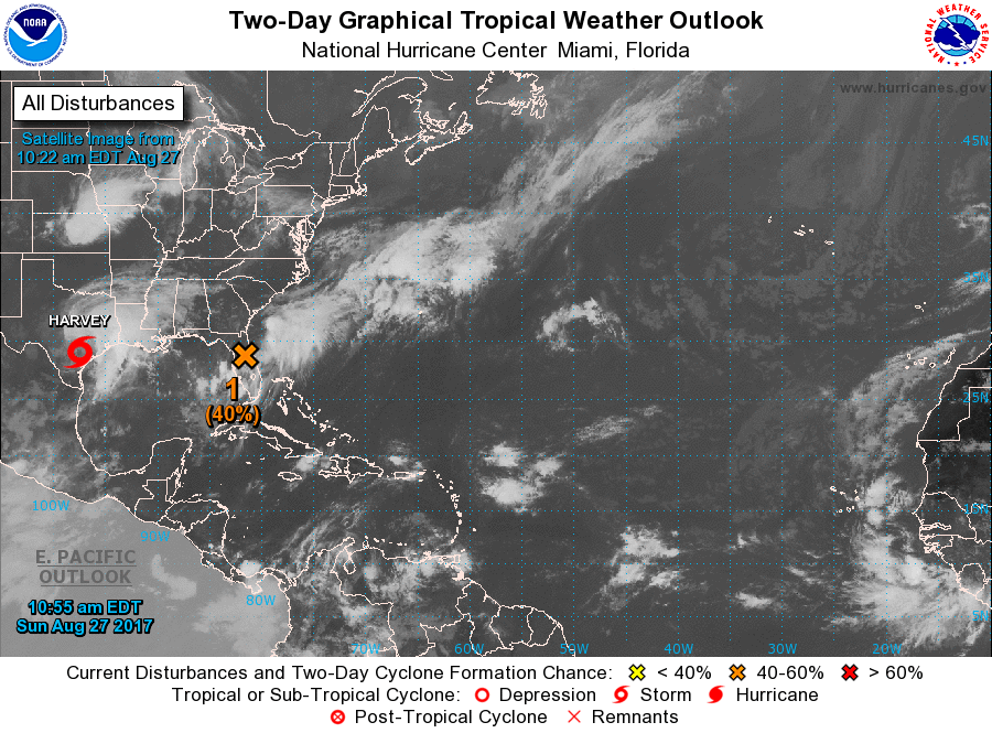
Invest 92L
This disturbance is currently located over north-central parts of the Florida Peninsula and is forecast to move slowly to the northeast and emerge out in the Atlantic. There is a medium chance that this could become a tropical depression within the next 5 days as it moves out to sea. There are no issues for Central Alabama from this one, but may bring increasing winds and rough surf to the coasts of Georgia and the Carolinas.
Got Beach Plans?
Be sure to keep up to date with the detailed forecasts from Fort Morgan over to Panama City Beach with the AlabamaWx Weather Blog. Click here to see the AlabamaWx Beach Forecast Center page.
The Beach Forecast is partially underwritten by the support of Brett/Robinson Vacation Rentals in Gulf Shores and Orange Beach. Click here to see Brett/Robinson’s Hot Deals now!
Advertise With Us!
Now is the time to set your marketing campaign on AlabamaWX. The site has enjoyed a 71% jump in page views this year! The website has already enjoyed 10,157,915 page views this year. We can customize a creative, flexible and affordable package that will suit your organization’s needs. Contact Bill Murray at (205) 687-0782.
E-Forecast
Get the AlabamaWx seven-day forecast delivered directly to your inbox by email twice daily. It is the most detailed weather forecast available in Central Alabama. Click here to subscribe. It’s free!
On This Day In Weather History
1964 – Hurricane Cleo battered Miami and the South Florida area. It was the first direct hit for Miami in fourteen years. Winds gusted to 135 mph, and the hurricane caused 125 million dollars damage.
WeatherBrains
Check out the show at www.WeatherBrains.com. You can also subscribe on iTunes. You can watch the show live at live.bigbrainsmedia.com on Monday nights starting at 8:30 PM CDT. You will be able to see the show on the James Spann 24×7 weather channel on cable or directly over the air on the dot 2 feed.
Category: Alabama's Weather, ALL POSTS
About the Author (Author Profile)
Scott Martin is an operational meteorologist, professional graphic artist, musician, husband, and father. Not only is Scott a member of the National Weather Association, but he is also the Central Alabama Chapter of the NWA president. Scott is also the co-founder of Racecast Weather, which provides forecasts for many racing series across the USA. He also supplies forecasts for the BassMaster Elite Series events including the BassMaster Classic.Subscribe
If you enjoyed this article, subscribe to receive more just like it.


