Deeper Moisture Headed For Alabama
EYES STILL ON HARVEY: Deeper moisture from Tropical Storm Harvey will move into Alabama over the next 24 hours. Still today rain across our state should be mostly light and scattered, although heavier rain is likely over Mobile and Baldwin Counties, where a flash flood watch is in effect. With a cloudy sky, we won’t get past the low 80s this afternoon. Very comfortable for late August.
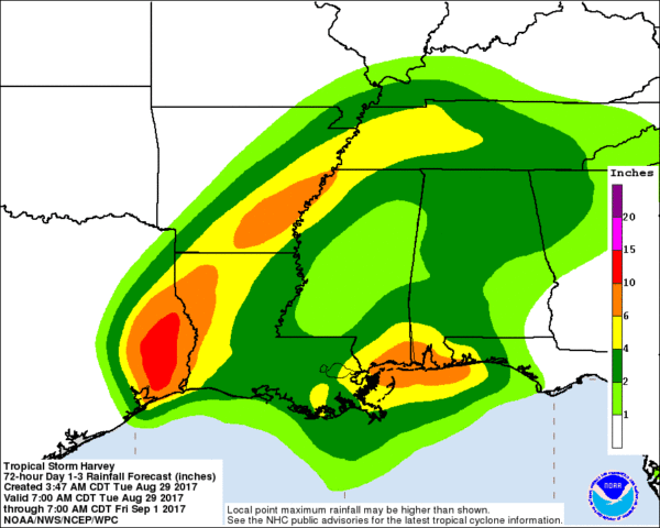
TOMORROW THROUGH FRIDAY: Harvey finally kicks out, with the center moving from near Lake Charles tomorrow to a point near Memphis by Friday night. This puts Alabama on the wet, east side of the circulation, and these three days look very wet with periods of rain and a few thunderstorms. Heaviest rain will be near the Gulf Coast, where 5-10 inches are possible for places like Dauphin Island and Gulf Shores. Amounts for the northern half of the state should be in the 2 to 4 inch range. Some flooding issues are possible along the way.
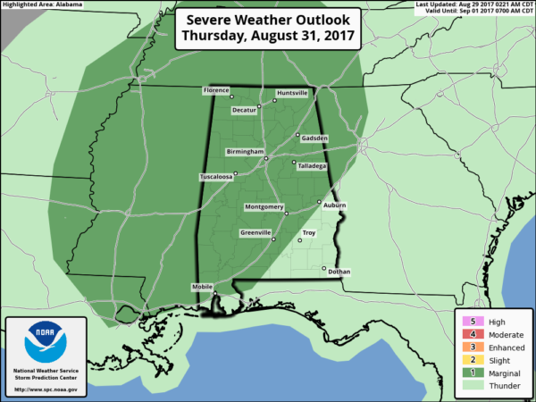
We will also have to watch for any thunderstorms that try and rotate; there is a low end tornado threat, mainly Thursday and Friday. SPC has much of Alabama in a “marginal” severe weather risk on Thursday, and most likely one will be required for Friday as well.
LABOR DAY WEEKEND: Computer models are clearly split. The American model, the GFS, keeps moisture in place with Harvey hanging around West Tennessee. This would suggest a wet beginning to the Labor Day weekend Saturday, followed by showers becoming fewer in number Sunday and Monday.
However, the reliable European global model kicks Harvey out to the northeast, and brings drier air into the region over the holiday weekend. Based on the better performance of the “Euro”, I will amend the forecast to be more optimistic and forecast increasing amounts of sunshine, and fewer showers over the weekend. Not ready to take out the chance of rain completely, but it sure looks better for college football and the beach. Highs over the weekend will be in the mid 80s.
FOOTBALL WEATHER: Alabama travels to Atlanta to take on Florida State Saturday (7:00 p.m. CT kickoff on ABC 33/40); the game will be played in the new Mercedes-Benz stadium indoors. Outside, it now looks like a decent part of the day Saturday will be dry with a mix of sun and clouds and just a few scattered showers. Temperatures will reach the low to mid 80s in Atlanta Saturday afternoon.
Auburn will host Georgia Southern Saturday evening at Jordan-Hare Stadium (6:30p CT kickoff)… the weather now looks pretty decent with a partly cloudy sky and only a small risk of a shower. The kickoff temperature will be near 80 degrees, falling into the mid 70s by the final whistle.
UAB will host Alabama A&M Saturday afternoon at Legion Field (2:30p CT kickoff on WABM, MY68)… again the forecast looks better with a mix of sun and clouds and only an outside risk of some rain during the game. About 83 degrees at kickoff, then close to 80 by the end of the game.
LABOR DAY WEEKEND AT THE BEACH: We will be much more optimistic now and forecast 6-8 hours of sunshine daily Saturday through Monday on the Gulf Coast from Gulf Shores over to Panama City Beach with only widely scattered showers and storms. Highs will be in the 80s.
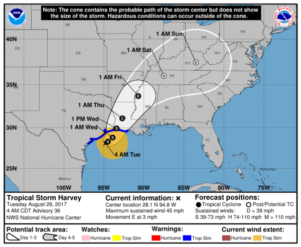
HARVEY: Tropical Storm Harvey is in the Gulf of Mexico, south of Galveston. It will make its second landfall south of Lake Charles tomorrow afternoon. This should be the last day of torrential rain for Houston… the system will lift north/northeast, passing west of Alabama in coming days.
PTCT: “Potential Tropical Cyclone Ten” is near Wilmington, North Carolina this morning, and still have a chance of becoming Tropical Storm Irma over the next 18 hours. After passing over the North Carolina coast and Outer Banks, it kicks out into the open Atlantic.
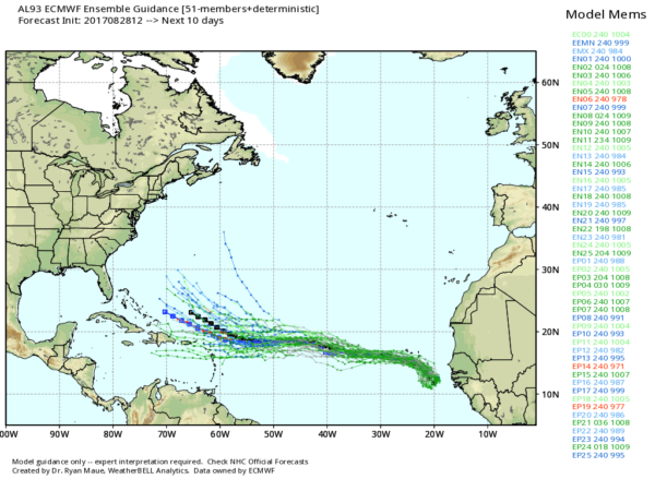
INVEST 93L: A disturbance in the eastern Atlantic has a high chance of becoming a tropical storm in coming days as it moves west/northwest. Way too early to determine the final destination; we note the European model keeps it on a lower latitude track. We will just have to keep an eye on it in coming days.
See the Weather Xtreme video for maps, graphics, and more details.
WEATHER BRAINS: Don’t forget you can listen to our weekly 90 minute netcast anytime on the web, or on iTunes. This is the show all about weather featuring many familiar voices, including our meteorologists here at ABC 33/40.
CONNECT: You can find me on all of the major social networks…
Facebook
Twitter
Google Plus
Instagram
Pinterest
Snapchat: spannwx
I am doing a weather program this morning at Lynn High School in Winston County… look for the next Weather Xtreme video here by 4:00 this afternoon. Enjoy the day!
Category: Alabama's Weather, ALL POSTS, Weather Xtreme Videos
About the Author (Author Profile)
James Spann is one of the most recognized and trusted television meteorologists in the industry. He holds the AMS CCM designation and television seals from the AMS and NWA. He is a past winner of the Broadcast Meteorologist of the Year from both professional organizations.Subscribe
If you enjoyed this article, subscribe to receive more just like it.


