Periods Of Rain Through Tomorrow; Dry Weekend Ahead
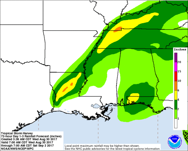
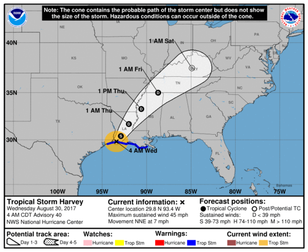
WET IS THE WORD: Tropical Storm Harvey is making a second landfall on the Louisiana coast south of Lake Charles this morning, and it is finally on the move. With a track west of Alabama, we will be on the wet side of the system, and Harvey promises to bring a good wet down to the state through tomorrow night.
We will forecast periods of rain with potential for a few thunderstorms as well. The rain could be heavy at times; for now it looks like the heaviest rain will be over Southwest Alabama, where a flash flood watch is in effect. Special Marine Warnings are up early this morning for the Alabama Gulf Coast, and earlier this morning a tornado warning was issued for Baldwin County.
We are now projecting rain amounts of 1-2 inches for the northern half of Alabama, with 2-4 inches for the southern quarter of the state.
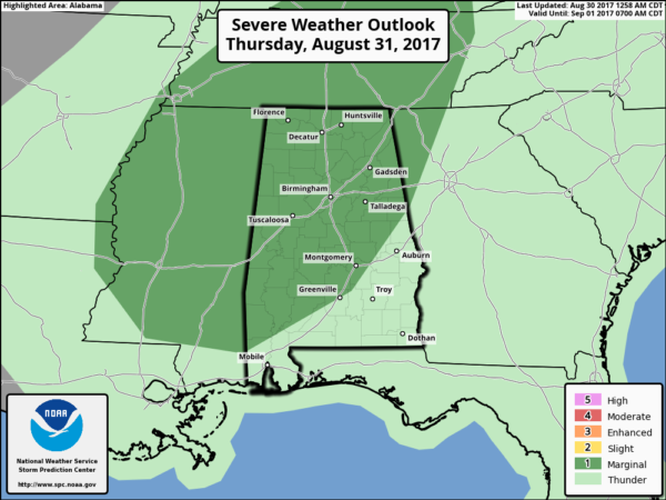
In addition to the threat of some heavy rain, we will have to watch for pockets of convection that rotate. We will have a low end tornado threat, mainly over the western half of the state. The highest threat will come tomorrow afternoon and evening, when shear and instability will peak.
Most tornadoes in tropical situations like this tend to be small and short lived, and providing warnings for them is a challenge since they are often low topped and literally “under the radar”. SPC has a marginal risk of severe weather defined for much of North/Central Alabama today and tomorrow, but we feel the best chance of an isolated tornado or two will be west of I-65.
Temperatures will stay mostly in the 70s today and tomorrow because of clouds and rain, well below average for late August. This, after all, is still summer and our average high today is 89 degrees.
FRIDAY: It now looks like a slot of dry air will work into Alabama, and showers/storms Friday should be widely scattered, and much of the day will be dry with a partly sunny sky. The high will be in the low to mid 80s.
LABOR DAY WEEKEND: Looks mostly rain-free for Alabama and much of the Deep South as Harvey continues to lift away. Mostly sunny warm days, fair pleasant nights Saturday through Sunday. Highs in the 80s, lows in the 60s. Cooler pockets could see 50s Sunday morning.
FOOTBALL WEATHER: Mostly fair for the high school games Friday night with temperatures falling through the 70s.
Alabama travels to Atlanta to take on Florida State Saturday (7:00 p.m. CT kickoff on ABC 33/40); the game will be played in the new Mercedes-Benz stadium indoors. Outside, it now looks like the waether will be dry Saturday and Saturday night.. temperatures will reach the low to mid 80s in Atlanta Saturday afternoon.
Auburn will host Georgia Southern Saturday evening at Jordan-Hare Stadium (6:30p CT kickoff)… we now project a mostly fair sky.. the kickoff temperature will be near 80 degrees, falling into the mid 70s by the final whistle.
UAB will host Alabama A&M Saturday afternoon at Legion Field (2:30p CT kickoff on WABM, MY68)… with a partly to mostly sunny sky temperatures will be around 85 degrees at kickoff, falling to near 80 by the end of the game.
LABOR DAY WEEKEND AT THE BEACH: Partly to mostly sunny weather Saturday through Monday from Gulf Shores west to Panama City Beach; just a few widely scattered showers or storms Monday. Highs in the 80s.
HARVEY: Severe flooding is in progress this morning in the Beaumont/Port Arthur areas (the southeast corner of Texas) with many urgent calls for water rescues. Conditions will improve there later this morning as Harvey moves northeast…
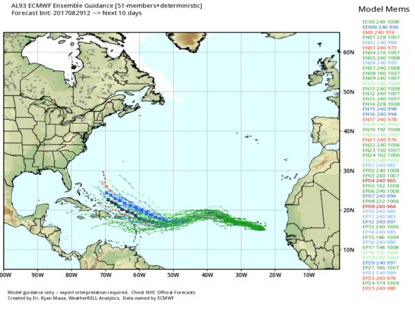
INVEST 93L: A disturbance in the far eastern Atlantic has a good chance of becoming Tropical Storm Irma in coming days as it moves to the west/northwest. Way too early to determine the final destination, or to know if this will impact any part of the U.S. coast.
BEACH FORECAST: Click here to see the AlabamaWx Beach Forecast Center page. The Beach Forecast is partially underwritten by the support of Brett/Robinson Vacation Rentals in Gulf Shores and Orange Beach. Click here to see Brett/Robinson’s Hot Deals now!
WEATHER BRAINS: Don’t forget you can listen to our weekly 90 minute netcast anytime on the web, or on iTunes. This is the show all about weather featuring many familiar voices, including our meteorologists here at ABC 33/40.
CONNECT: You can find me on all of the major social networks…
Facebook
Twitter
Google Plus
Instagram
Pinterest
Snapchat: spannwx
I am doing a weather program this morning at Clanton Middle School… look for the next Weather Xtreme video here by 4:00 this afternoon. Enjoy the day!
Category: Alabama's Weather, ALL POSTS, Weather Xtreme Videos
About the Author (Author Profile)
James Spann is one of the most recognized and trusted television meteorologists in the industry. He holds the AMS CCM designation and television seals from the AMS and NWA. He is a past winner of the Broadcast Meteorologist of the Year from both professional organizations.Subscribe
If you enjoyed this article, subscribe to receive more just like it.


