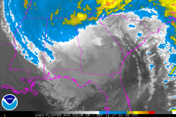
Irma Weakens To A Tropical Depression
HEAVY RAINFALL CONTINUES ACROSS THE SOUTHEASTERN UNITED STATES
SUMMARY OF 1100 PM EDT…0300 UTC…INFORMATION
———————————————–
LOCATION…32.4N 84.9W
ABOUT 5 MI…10 KM S OF COLUMBUS GEORGIA
ABOUT 95 MI…150 KM SSW OF ATLANTA GEORGIA
MAXIMUM SUSTAINED WINDS…35 MPH…55 KM/H
PRESENT MOVEMENT…NW OR 320 DEGREES AT 15 MPH…24 KM/H
MINIMUM CENTRAL PRESSURE…988 MB…29.18 INCHES
——————–
CHANGES WITH THIS ADVISORY:
All Storm Surge Warnings and Tropical Storm Warnings have been
discontinued.
SUMMARY OF WATCHES AND WARNINGS IN EFFECT:
There are no coastal watches or warnings in effect.
Interests in the southeastern United States should monitor the
progress of Irma.
DISCUSSION AND 48-HOUR OUTLOOK
——————————
At 1100 PM EDT (0300 UTC), the center of Tropical Depression Irma
was located near latitude 32.4 North, longitude 84.9 West. The
depression is moving toward the northwest near 15 mph (24 km/h), and
this motion at a slightly slower speed is expected through Monday.
A turn toward the north-northwest is forecast Monday night. On the
forecast track, the center of Irma will move into Alabama soon and
then into western Tennessee by Monday evening.
Maximum sustained winds have decreased to near 35 mph (55 km/h) with
higher gusts. Additional weakening is forecast, and Irma is
expected to degenerate into a remnant low by Monday evening. The
low is likely to dissipate by Tuesday evening.
The estimated minimum central pressure is 988 mb (29.18 inches).
HAZARDS AFFECTING LAND
———————-
STORM SURGE: Water levels are gradually subsiding along the
southeastern United States coast and the west coast of Florida.
WIND: Gusty winds to tropical storm force are possible near the
coast of South Carolina and in heavier rainbands across the
southeastern United States overnight.
RAINFALL: Irma is expected to produce rain accumulations of 2 to 5
inches with isolated 8 inches through Wednesday across South
Carolina and northern portions of Georgia, Alabama, and Mississippi
into Tennessee and North Carolina.
SURF: Swells generated by Irma are affecting the southeast coast of
the United States. These swells are likely to cause life-
threatening surf and rip current conditions. Please consult
products from your local weather office.
NEXT ADVISORY
————-
This is the last public advisory issued by the National Hurricane
Center on this system. Future information on this system can be
found in Public Advisories issued by the Weather Prediction Center
beginning at 5 AM EDT, under AWIPS header TCPAT1, WMO header
WTNT31 KWNH, and on the web at http://www.wpc.ncep.noaa.goV.


