Harvey’s Heavy Rains Are Affecting Central Alabama
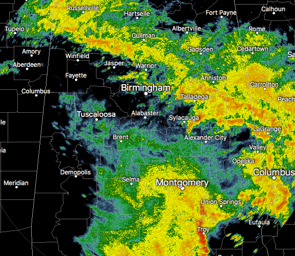
At 11:00 AM, moderate to heavy rainfall is falling over much of the Central Alabama area at this time, as we are now receiving what the outside feeder band from Harvey has to offer. This band is stretching from Red Bay and Tuscumbia down to the east-southeast into Cullman and Warrior and down into Talladega and Roanoke. Another large band of rain has set up over the southern parts of the area and stretching back to the south-southwest into the southwestern parts of the state and down across the Gulf Coast.
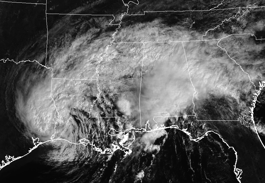
Heavy rains from Harvey continue to affect already-drenched locations in eastern Texas and into Louisiana. Heavy rain is also causing some flooding issues along the Gulf Coast, especially in Orange Beach to Perdido Key. All of this activity will eventually move to the north-northeast and accelerate in forward motion this afternoon and throughout the next couple of days.
Looking Ahead For This Afternoon and Early Evening
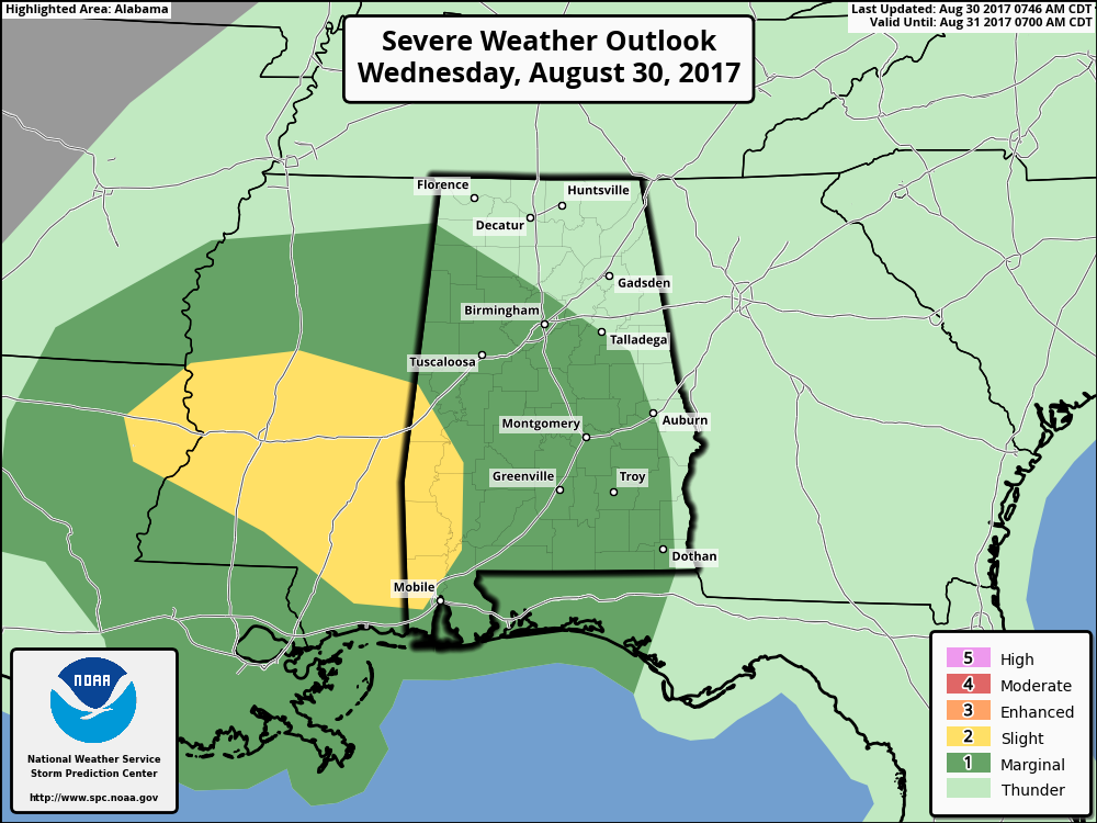
The NWS Office in Mobile has issued a Tornado Watch for several counties in the extreme southeastern parts, and the thinking is that most of that activity will eventually push into southwestern Alabama and then up into the southwestern and western parts of Central Alabama. There will be a small threat for a brief tornado or two during the afternoon and early evening hours, mainly for the western half of Central Alabama. The threat for those will diminish this evening as we lose the heating of the day and a dry slot will be moving in from the southwest.
There may be a small threat of localized ponding and flash flooding from heavy rain and training of those heavier pockets over the same general areas. A feeder band from Harvey looks to be setting up along and east of the I-65 corridor, and the best chance of the training effect will be mainly from the Birmingham metropolitan area down to Montgomery. 1-2 inches of rainfall can be expected area-wide, with heavier localized amounts. Much of the heaviest rainfall in the state will occur in the southwestern parts of the state and along the Gulf Coast, where they are already having flooding issues.
The bottom line… expect cloudy skies throughout the remainder of the afternoon and early evening hours with periods of rain and a few embedded thunderstorms. A few brief spin-up tornadoes are possible mainly west of I-65. Heavy rains could cause some localized flash flooding mainly south of Birmingham around and east of the I-65 corridor. Afternoon highs will range in the mid-70s to the mid-80s throughout the area. We’ll continue to have periods of rain throughout the late evening through the overnight hours, but no tornado threat tonight. Localized flash flooding still could be a possibility. Lows will be in the upper 60s to the lower 70s.
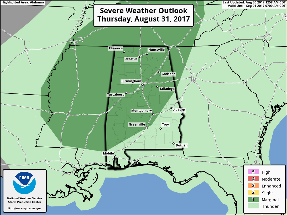
Marginal Risk For Severe Storms On Thursday
Much of the same story for tomorrow… Continued cloudy skies with periods of rain with a few embedded thunderstorms. Once again, a few brief spin-up tornadoes will be possible throughout the day, especially after the late morning hours. Some localized flash flooding will be possible again, especially in poor drainage areas. Highs are expected to be in the lower to mid-80s, but I believe a few spots with heavier rain will be held back in the 70s.
Friday Is Trending Drier And A Little Brighter
Harvey will be quickly moving off to the northeast and moisture will be pulling out as well. A good bit of the day could be dry and we could see a few peeks of sun throughout the day. We could still have a few showers to wrap around the southern side of the center of circulation that could move mainly through the northern half of the area. Afternoon highs will range throughout the 80s.
Got Beach Plans?
Be sure to keep up to date with the detailed forecasts from Fort Morgan over to Panama City Beach with the AlabamaWx Weather Blog. Click here to see the AlabamaWx Beach Forecast Center page.
The Beach Forecast is partially underwritten by the support of Brett/Robinson Vacation Rentals in Gulf Shores and Orange Beach. Click here to see Brett/Robinson’s Hot Deals now!
Advertise With Us!
Now is the time to set your marketing campaign on AlabamaWX. The site has enjoyed a 71% jump in page views this year! The website has already enjoyed 10,157,915 page views this year. We can customize a creative, flexible and affordable package that will suit your organization’s needs. Contact Bill Murray at (205) 687-0782.
E-Forecast
Get the AlabamaWx seven-day forecast delivered directly to your inbox by email twice daily. It is the most detailed weather forecast available in Central Alabama. Click here to subscribe. It’s free!
Category: Alabama's Weather, ALL POSTS
About the Author (Author Profile)
Scott Martin is an operational meteorologist, professional graphic artist, musician, husband, and father. Not only is Scott a member of the National Weather Association, but he is also the Central Alabama Chapter of the NWA president. Scott is also the co-founder of Racecast Weather, which provides forecasts for many racing series across the USA. He also supplies forecasts for the BassMaster Elite Series events including the BassMaster Classic.Subscribe
If you enjoyed this article, subscribe to receive more just like it.


