Tropics Will be Very Active Over Next Two Weeks
As we head toward the peak of the North Atlantic Hurricane Season, the basin continues to be active and will continue to be over the next two weeks, including more activity in the Gulf.
HARVEY
Harvey is beginning to weaken as it pushes north northeastward through West Central Louisiana. It is about 70 miles southwest of Alexandria LA this afternoon with top winds of 40mph. It will become a tropical depression later this afternoon. It should remain a tropical depression through Friday morning as it pushes across northwestern Mississippi and into western Tennessee by Friday morning. Severe weather will be a problem into western Alabama into this evening, dying out with the loss of the daytime heating. But tomorrow looks like it may be the best chance for severe weather. The greatest threat looks like after 3 p.m. tomorrow with a well-defined feeder band that could produce tornadoes and locally heavy rain.
POTENTIAL TROPICAL CYCLONE TEN
Missed the opportunity to become a tropical storm or hurricane, but it is producing hurricane force winds over the open Atlantic about 400 miles east of Long Island. It is producing 20-foot seas.
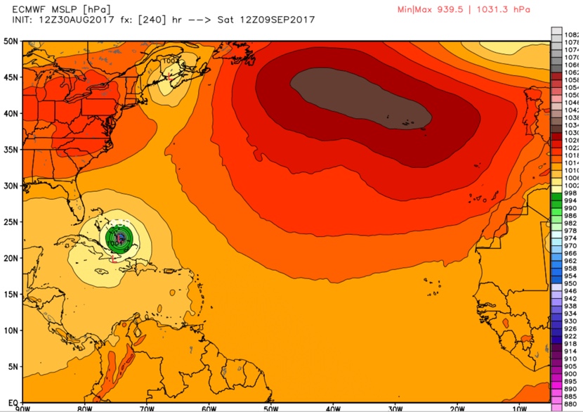
IRMA
It is looking like Tropical Storm Irma will become a classic Cape Verde monster. Irma will track westward, becoming a hurricane before Friday morning. The Bermuda High will keep it suppressed to the south, heading it toward the northern Leeward Islands by Tuesday night. It will track toward the Bahamas and ten days from now, and could be a major hurricane threatening South Florida. From there it could go toward the Gulf or start turning toward Georgia and the Carolinas.
Here is a look at the Euro for Thursday afternoon, September 7th.
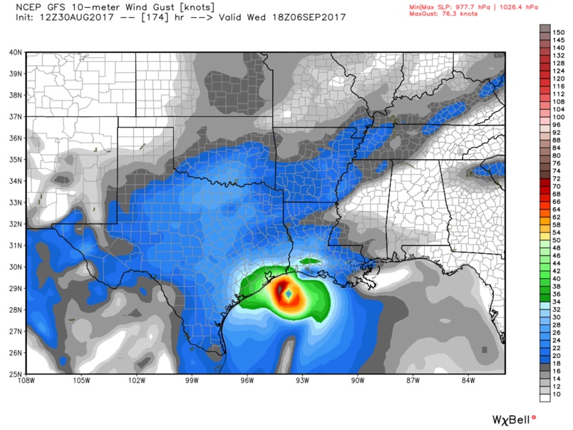
GULF DISTURBANCE
The GFS and European, as well as the Canadian and other models have been promoting the idea of a tropical storm or hurricane developing over the southwestern Gulf of Mexico and the Bay of Campeche by Saturday or Sunday. The morning run of the GFS carries the storm toward the Upper Texas or Louisiana coast and turns it eastward along the northern Gulf Coast. The morning run of the European turns it back southward over the southern Gulf. So, still lots of uncertainty, but certainly the possibility that we will be dealing with another Gulf hurricane.
Here is the GFS for Wednesday, September 6th.
We will be watching!
About the Author (Author Profile)
Bill Murray is the President of The Weather Factory. He is the site's official weather historian and a weekend forecaster. He also anchors the site's severe weather coverage. Bill Murray is the proud holder of National Weather Association Digital Seal #0001 @wxhistorianSubscribe
If you enjoyed this article, subscribe to receive more just like it.


