Heavy Rain/Tornado Potential Tomorrow
THIS AFTERNOON: A large area of rain was moving through North and East Alabama this afternoon, but a decent part of the state is getting a break from the rain. Severe thunderstorm and flash flood warnings have been required for parts of Southwest Alabama today, and a few tornadoes have touched down in South Mississippi, where a tornado watch remains in effect until 6pm CT.
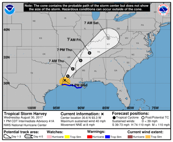
TONIGHT/TOMORROW: As Tropical Storm Harvey moves to the northeast on a track that is west of Alabama, it will keep our weather unsettled through tomorrow with occasional rain and a few thunderstorms. The rain could be heavy at times, and we will have the proper combination of shear and instability tomorrow for the potential for a few isolated tornadoes. SPC has the northern third of the state in the standard “slight risk” tomorrow, with a “marginal risk” down to Jackson, Greenville, and Opelika.
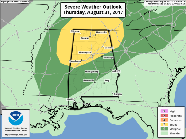
Rain amounts of 1-2″ are likely by tomorrow night, with locally heavier amounts. Southwest Alabama remains under a flash flood watch, but for now a watch has not been issued for North or Central Alabama.
THE TORNADO THREAT: The primary risk of isolated tornadoes will come from about 12:00 noon tomorrow through 7:00 tomorrow evening, when the air will be most unstable. But, we can’t rule out some trouble after midnight tonight and tomorrow morning. Remember, with tropical systems the tornadoes in spiral bands rotating around the circulation center tend to be short lived, and low topped. They are often under the radar, and can easily touch down with no warning. Just just be very weather aware tomorrow and pay attention to watches and warnings if they are needed.
FRIDAY: A nice dry slot moves into Alabama. The day will be partly sunny, and while a few showers and storms are possible, they should be few and far between. The high will be in the low to mid 80s.
LABOR DAY WEEKEND: Dry air will cover Alabama and much of the Deep South. We project mostly sunny warm days, and fair pleasant nights Saturday through Monday. Highs will be in the 80s, with lows in the upper 50s and low 60s. Cooler pockets could see low to mid 50s early Sunday and Monday morning for a very nice touch of fall.
FOOTBALL WEATHER: Mostly fair for the high school games Friday night with temperatures falling through the 70s.
Alabama travels to Atlanta to take on Florida State Saturday (7:00 p.m. CT kickoff on ABC 33/40); the game will be played in the new Mercedes-Benz stadium indoors. Outside, it now looks like the waether will be dry Saturday and Saturday night.. temperatures will reach the low to mid 80s in Atlanta Saturday afternoon.
Auburn will host Georgia Southern Saturday evening at Jordan-Hare Stadium (6:30p CT kickoff)… we now project a mostly fair sky.. the kickoff temperature will be near 80 degrees, falling into the mid 70s by the final whistle.
UAB will host Alabama A&M Saturday afternoon at Legion Field (2:30p CT kickoff on WABM, MY68)… with a partly to mostly sunny sky temperatures will be around 85 degrees at kickoff, falling to near 80 by the end of the game.
LABOR DAY WEEKEND AT THE BEACH: Partly to mostly sunny weather Saturday through Monday from Gulf Shores west to Panama City Beach; just a few widely scattered showers or storms Monday. Highs in the 80s.
HARVEY: Tropical Storm Harvey moved inland over Southwest Louisiana this morning; the circulation will pass through North Mississippi, Middle Tennessee, and will be approaching Cincinnati by Sunday morning. This is what will bring our unsettled weather tonight and tomorrow, but it will also be responsible for pulling dry air into the state over the holiday weekend.
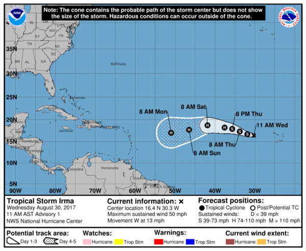
IRMA: A new tropical storm has formed in the eastern Atlantic. Irma is expected to become a hurricane in coming days as it moves to the west/northwest. It is simply way too early to know if this will be a threat to the Gulf of Mexico or any part of the U.S. coast.
And, we should mention global models develop another system in the Gulf of Mexico next week. Again, simply too early to know if this will impact the Gulf Coast. Lots to watch in coming days.
BEACH FORECAST: Click here to see the AlabamaWx Beach Forecast Center page. The Beach Forecast is partially underwritten by the support of Brett/Robinson Vacation Rentals in Gulf Shores and Orange Beach. Click here to see Brett/Robinson’s Hot Deals now!
WEATHER BRAINS: Don’t forget you can listen to our weekly 90 minute netcast anytime on the web, or on iTunes. This is the show all about weather featuring many familiar voices, including our meteorologists here at ABC 33/40.
CONNECT: You can find me on all of the major social networks…
Facebook
Twitter
Google Plus
Instagram
Pinterest
Snapchat: spannwx
I had a great time today visiting with the 6th graders at Clanton Middle School… be looking for them on the Pepsi KIDCAM today at 5:00 on ABC 33/40 News! The next Weather Xtreme video will be posted here by 7:00 a.m. tomorrow…
Category: Alabama's Weather, ALL POSTS, Weather Xtreme Videos
About the Author (Author Profile)
James Spann is one of the most recognized and trusted television meteorologists in the industry. He holds the AMS CCM designation and television seals from the AMS and NWA. He is a past winner of the Broadcast Meteorologist of the Year from both professional organizations.Subscribe
If you enjoyed this article, subscribe to receive more just like it.


