Cold Front Arrives Late Tomorrow Night
REFRESHING MORNING: Many North/Central Alabama communities are in the mid to upper 50s early this morning for a nice fall feel. Today will be another sunny day, and we rise into the upper 80s this afternoon.
FRONT ON THE WAY: We will bring in a chance of showers, and possibly a thunderstorm tomorrow afternoon and tomorrow night ahead of an approaching cold front. No severe weather is expected, and rain amounts of around 1/2 inch are likely. The showers will end during the early morning hours Wednesday, followed by a cooler, drier airmass. The sky should become partly to mostly sunny during the day Wednesday with lower humidity… the high will drop into the mid 70s.
REST OF THE WEEK AND THE WEEKEND: Dry, continental air will cover Alabama and the Deep South with sunny pleasant days and clear, cool nights Thursday through Sunday. Highs 78-82… lows mostly in the 50s. Some of the cooler pockets across North/Central Alabama could actually visit the upper 40s early Thursday and Friday morning. Sure looks like another great weekend for both high school and college football.
HURRICANE IRMA: Irma remains a dangerous, category three hurricane early this morning in the Atlantic with sustained winds of 120 mph. Irma is moving to the west, and tropical storm force winds are expected to begin in the northern Leeward Islands late tomorrow.
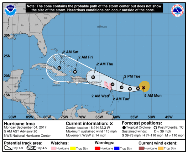
Tropical storm or hurricane watches will likely be issued for the British and U.S. Virgin Islands and Puerto Rico later today. The official forecast track from the National Hurricane Center places Irma near the north coast of Cuba late Friday night, and from there most all dynamic models show a hard right turn. Some important points…
*Concerning the official forecast from NHC, don’t focus on the exact forecast track since strong winds and heavy rainfall extend well away from the center. In addition, average NHC track errors are about 175 and 225 statute miles at days 4 and 5, respectively.
*It is simply too early to know when that right turn happens, and the specific impact for Florida and the U.S. Atlantic coast. Irma could make landfall, or recurve with the center remaining over water.
*There is a good chance Irma does not enter the Gulf of Mexico; for now no direct impact is expected in Gulf Shores, Destin, or Panama City Beach. But, no total guarantee.
*People from Key West north, through Miami, Daytona Beach, Savannah, Charleston, and up to the Outer Banks of North Carolina need to review their hurricane plans and be ready in case action is needed in 4-7 days from now. Based on the latest forecast, tropical storm force winds could arrive in South Florida as early as Friday morning.
*One way or another, large waves and rough surf will be generated along the South Atlantic U.S. coast this weekend and early next week.
NOAA research aircraft have been in the area, and the data will be in the new computer model runs that we see later today and tonight giving us better clarity. We do ask that you don’t share outrageous, false claims about Irma across social media (it will be a “category six” and “wipe cities off the map”). Stick with official products from the National Hurricane Center.
REST OF THE TROPICS: A trailing wave behind Irma should become Tropical Storm Jose in coming days; a fair chance this one recurves into the open Atlantic.
Another disturbance over the far Southwest Gulf of Mexico is being monitored, but only a low chance of development in coming days. See the Weather Xtreme video for maps, graphics, and more details.
WEATHER BRAINS: Don’t forget you can listen to our weekly 90 minute netcast anytime on the web, or on iTunes. This is the show all about weather featuring many familiar voices, including our meteorologists here at ABC 33/40. We will produce this week’s show tonight at 8:30p CT… you can watch it live here.
CONNECT: You can find me on all of the major social networks…
Facebook
Twitter
Google Plus
Instagram
Pinterest
Snapchat: spannwx
Look for the next Weather Xtreme video here by 4:00 this afternoon… enjoy the day!
Category: Alabama's Weather, ALL POSTS, Weather Xtreme Videos
About the Author (Author Profile)
James Spann is one of the most recognized and trusted television meteorologists in the industry. He holds the AMS CCM designation and television seals from the AMS and NWA. He is a past winner of the Broadcast Meteorologist of the Year from both professional organizations.Subscribe
If you enjoyed this article, subscribe to receive more just like it.


