Showers Tomorrow Afternoon; Eyes On Irma
LOVELY LABOR DAY: With a sunny sky, temperatures are mostly in the mid 80s this afternoon across the great state of Alabama with low humidity. The sky will remain mostly fair tonight.
TOMORROW/WEDNESDAY/THURSDAY: We will bring in the chance of showers, and possibly a thunderstorm tomorrow afternoon and tomorrow night as a cold front approaches from the north. No severe weather is expected, and rain amounts of around 1/2 inch are likely.
The showers should end during the pre-dawn hours Wednesday; the sky becomes partly to mostly sunny as a new surge of cool, dry air works into Alabama. The high Wednesday will drop into the upper 70s, and by daybreak Thursday most places will see a low between 50 and 55 degrees, a very nice fall feel. Colder pockets could see upper 40s.
Thursday will be a picture perfect day with sunshine in full supply along with a high in the upper 70s. The humidity will stay low.
FRIDAY AND THE WEEKEND: Dry weather continues. Mostly sunny pleasant days, clear cool nights. Highs 80-85, lows in the 50s, although Sunday morning will feature a low in the 60s. Looks great for high school and college football games across Alabama this weekend.
NEXT WEEK: For now it looks like the weather will stay dry most of the week as we will be on the “dry side” of the circulation of Hurricane Irma.
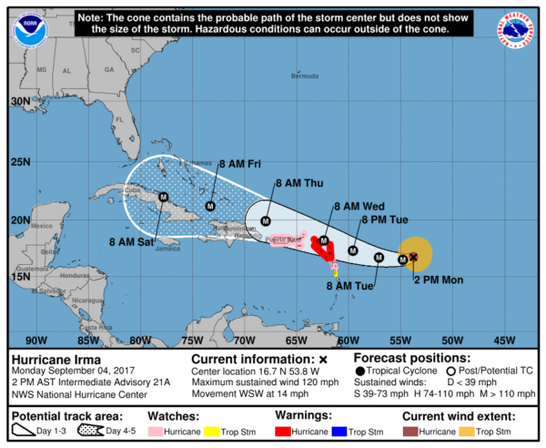
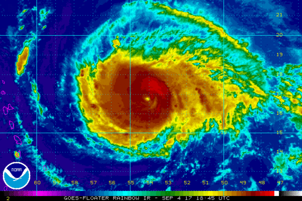
EYES ON IRMA: Hurricane Irma is packing sustained winds of 120 mph, and continues to move in a general westerly direction.
A Hurricane Warning is in effect for…
* Antigua, Barbuda, Anguilla, Montserrat, St. Kitts, and Nevis
* Saba, St. Eustatius, and Sint Maarten
* Saint Martin and Saint Barthelemy
A Hurricane Watch is in effect for…
* Guadeloupe
* British Virgin Islands
* U.S. Virgin Islands
* Puerto Rico, Vieques, and Culebra
A Tropical Storm Warning is in effect for…
* Guadeloupe
A Tropical Storm Watch is in effect for…
* Dominica
Here are the important notes this afternoon…
*Concerning the official forecast from NHC, don’t focus on the exact forecast track since strong winds and heavy rainfall extend well away from the center. In addition, average NHC track errors are about 175 and 225 statute miles at days 4 and 5, respectively.
*Irma is expected to take a hard right turn over Cuba late this week, or early in the weekend. It is simply too early to know when that right turn happens; the timing of the turn will determine the impact over Florida.
*There is an increasing chance of seeing significant impact from Irma in the Florida Peninsula (not the Panhandle) and the Florida Keys his weekend. Tropical storm force winds could arrive in South Florida by Friday evening. In addition, rough surf and dangerous marine conditions will begin to affect the southeastern U.S. coast by later this week.
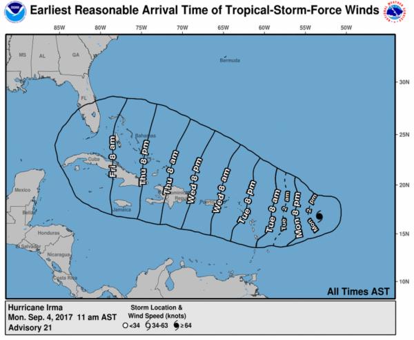
*As a course of least regret, people in South Florida should continue preparations for a major hurricane. The main impact over Florida will come Saturday, Sunday, and possibly Monday (September 9-11).
*Those along the Georgia, South Carolina, and North Carolina coasts need to monitor the progress of this dangerous hurricane closely.
*There is a very good chance Irma does not enter the Gulf of Mexico; for now no direct impact is expected in Gulf Shores, Destin, or Panama City Beach. This is high confidence, but no total guarantee.
OTHER TROPICAL NEWS: A disturbance in the far Southwest Gulf of Mexico has a medium chance of slow development this week, and a wave trailing Irma in the Atlantic has a good chance of becoming Tropical Storm Jose over the next three to five days. We will keep an eye on both.
BEACH FORECAST: Click here to see the AlabamaWx Beach Forecast Center page. The Beach Forecast is partially underwritten by the support of Brett/Robinson Vacation Rentals in Gulf Shores and Orange Beach. Click here to see Brett/Robinson’s Hot Deals now!
WEATHER BRAINS: Don’t forget you can listen to our weekly 90 minute netcast anytime on the web, or on iTunes. This is the show all about weather featuring many familiar voices, including our meteorologists here at ABC 33/40.
CONNECT: You can find me on all of the major social networks…
Facebook
Twitter
Google Plus
Instagram
Pinterest
Snapchat: spannwx
Look for the next Weather Xtreme video here by 7:00 a.m. tomorrow…
Category: Alabama's Weather, ALL POSTS, Weather Xtreme Videos
About the Author (Author Profile)
James Spann is one of the most recognized and trusted television meteorologists in the industry. He holds the AMS CCM designation and television seals from the AMS and NWA. He is a past winner of the Broadcast Meteorologist of the Year from both professional organizations.Subscribe
If you enjoyed this article, subscribe to receive more just like it.


