Strong Storms Over North Alabama/Irma A Cat 5
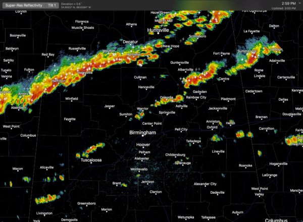
RADAR CHECK: Showers and strong storms have formed across the northern half of Alabama this afternoon ahead of a cold front. Heavier storms are producing lots of lightning, gusty winds, heavy rain, and some small hail. They are moving east/southeast, and will end late tonight as cooler, drier air behind the front rolls in.
TOMORROW THROUGH THE WEEKEND: Any showers tomorrow will be confined to the southern quarter of the state, otherwise we expect sunny pleasant days and clear cool nights tomorrow through Sunday. Highs will be in the upper 70s tomorrow and Thursday, followed by low 80s Friday through the weekend. Morning lows will mostly be in the cool 50s… some of the normally colder pockets across North/Central Alabama could reach the upper 40s early Thursday and Friday morning.
The weather looks fantastic for high school football games across the state Thursday and Friday night, and the college games Saturday.
AUBURN/CLEMSON: For those Auburn fans headed to South Carolina this weekend, the weather looks fine for the game Saturday night in Clemson (7:00p ET kickoff)… the sky will be clear with temperatures falling through the 60s. Any impact from Hurricane Irma will come early next week in South Carolina.
NEXT WEEK: The pattern looks mostly dry in Alabama; but the eastern counties could see some rain late Monday night or Tuesday on the far eastern periphery of Irma. Simply too early to know for sure, but one way or another Alabama will be on the dry, west side of the circulation.
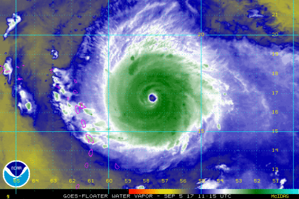
IRMA REMAINS A DANGEROUS CATEGORY FIVE HURRICANE: Irma now has sustained winds of 185 mph… tied for second strongest hurricane on record (based on wind) in the Atlantic basin. It is tied with the Labor Day Florida Keys hurricane of 1935, and Hurricane Wilma in 2005. Hurricane Allen is number one on that list with sustained winds of 190 mph (1980).
A Hurricane Warning is in effect for…
* Antigua, Barbuda, Anguilla, Montserrat, St. Kitts, and Nevis
* Saba, St. Eustatius, and Sint Maarten
* Saint Martin and Saint Barthelemy
* British Virgin Islands
* U.S. Virgin Islands
* Puerto Rico, Vieques, and Culebra
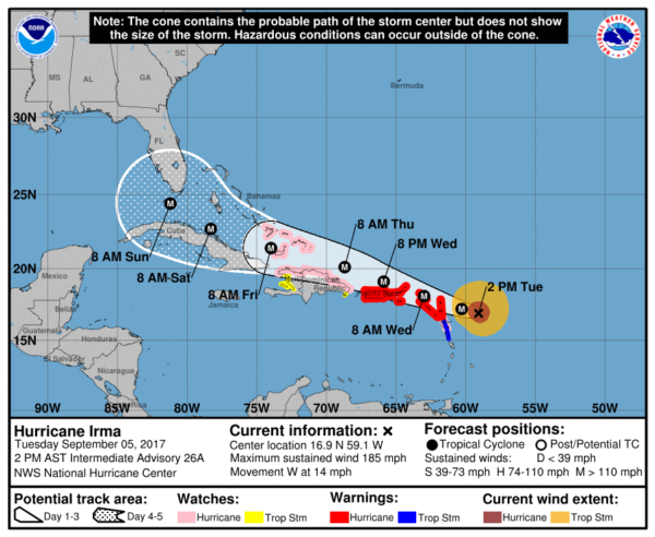
Irma is expected to be over the Florida Keys Sunday morning, where a sharp right turn is forecast, bringing the center over parts of the Florida Peninsula Sunday into Monday.
Here are some important notes…
*Do not focus on the exact forecast forecast track, especially at the longer ranges, since the average NHC track errors are about 175 and 225 statute miles at days 4 and 5, respectively.
*The placement and timing of the right turn of Irma will determine the specific impact on the Florida Peninsula Sunday and Monday. It is simply too early to be specific, but everyone across the peninsula (cities like Miami, Fort Lauderdale, Tampa, Orlando, Daytona Beach, Jacksonville, etc) need to prepare for a major hurricane. Listen to local authorities, and heed evacuation orders.
I would suggest no travel to any part of the Florida Peninsula this weekend; understand Irma is a vigorous, dangerous hurricane.
*It is very likely that Irma will not enter the Gulf of Mexico, with the exception of the far southeast corner near the Florida Keys.
*No direct impact is expected on Alabama, or the Central Gulf Coast (Gulf Shores, Pensacola, Navarre Beach, Destin). Some wind and rain is possible at Panama City Beach by Sunday and Monday, but it will be on the “good” west side of the circulation. There is a chance Panama City Beach sees no rain at all.
*Heavy rain will be possible over parts of Georgia and the Carolinas next week along with gusty winds as Irma moves northeast, but it is simply too early to know the specific impact.
TROPICAL STORM JOSE: The trailing wave behind Irma is now Tropical Storm Jose; it is expected to slowly strengthen, becoming a hurricane in 3-5 days. This one will gain latitude and for now seems to be no immediate threat to land. We will keep an eye on it.
INVEST 95L: The disturbance over the Bay of Campeche (the far Southwest Gulf of Mexico) is expected to drift into Mexico in coming days. No threat to Texas.
See the Weather Xtreme video for maps, graphics, and more details.
BEACH FORECAST: Click here to see the AlabamaWx Beach Forecast Center page. The Beach Forecast is partially underwritten by the support of Brett/Robinson Vacation Rentals in Gulf Shores and Orange Beach. Click here to see Brett/Robinson’s Hot Deals now!
WEATHER BRAINS: Don’t forget you can listen to our weekly 90 minute netcast anytime on the web, or on iTunes. This is the show all about weather featuring many familiar voices, including our meteorologists here at ABC 33/40. We will produce this week’s show tonight at 8:30p CT… you can watch it live here.
CONNECT: You can find me on all of the major social networks…
Facebook
Twitter
Google Plus
Instagram
Pinterest
Snapchat: spannwx
Look for the next Weather Xtreme video here by 7:00 a.m. tomorrow…
Category: Alabama's Weather, ALL POSTS, Weather Xtreme Videos
About the Author (Author Profile)
James Spann is one of the most recognized and trusted television meteorologists in the industry. He holds the AMS CCM designation and television seals from the AMS and NWA. He is a past winner of the Broadcast Meteorologist of the Year from both professional organizations.Subscribe
If you enjoyed this article, subscribe to receive more just like it.


