Late Thursday Night Update On Irma
THURSDAY NIGHT (11pm CT) IRMA UPDATE…
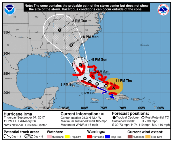
Hurricane Irma is moving toward the west-northwest near 16 mph, and this motion is expected to continue for the next day or two with a decrease in forward speed. A turn toward the northwest is expected by late Saturday. On the forecast track, the eye of Irma should continue to move westward away from the Turks and Caicos Islands and toward the southeastern Bahamas overnight. The core of the hurricane will then move between the north coast of Cuba and the Bahamas during the next day or two.
Maximum sustained winds are near 165 mph with higher gusts. Irma is a category 5 hurricane on the Saffir-Simpson Hurricane Wind Scale. Some fluctuations in intensity are likely during the next day or two, but Irma is forecast to remain a powerful category 4 or 5 hurricane during the next couple of days.
Hurricane warnings have now been issued for South Florida and the Florida Keys.
IMPORTANT NOTES…
*The worst impact from storm surge and wind will be along and east of the circulation center, which is now forecast by NHC to go right up the spine of Florida. The most severe damage should be on the Atlantic coast from Miami up through Daytona Beach and Jacksonville late Saturday night and into Sunday.
*The Florida west coast (cities like Naples, Fort Myers, Sarasota, St Petersburg, and Tampa) are on the west side of the system, but due to it’s strength wind damage is very possible there Sunday along with widespread power outages and some flooding.
*Hurricane force winds are likely in Orlando Sunday. Potential for structural damage there. I would not want to be in Orlando Sunday; the weather will be much better by Monday.
*Irma is expected to move northward through Georgia Monday; main impact will be along and east of the circulation center where heavy rain, gradient winds of 40-50 mph, and a few isolated tornadoes will be possible.
*The threat of a second landfall on the Georgia or South Carolina coast for now has diminished somewhat, but people there still need to be prepared in case the track is adjusted eastward again (which is very possible). And, there will still be lots of wind and rain on the GA and lower SC coast Sunday night and Monday.
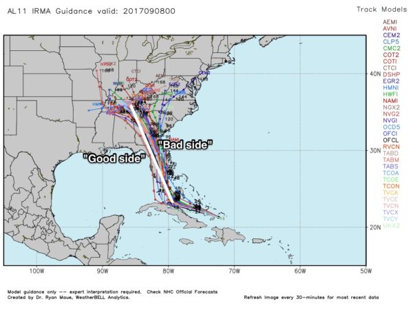
*The remnant circulation is now expected to drift westward over Tennessee, which means Alabama will have some rain from the system Monday night and Tuesday. Thankfully Alabama remains on the “good” side, meaning no flooding is expected, and there won’t be a tornado threat (the tornado threat will be confined to the eastern side).
*The Central Gulf Coast will be on the “good side”. No rain is expected for Gulf Shores or Pensacola, but Sunday and Monday will feature a gusty north wind (offshore flow).
*Winds will be a bit higher as you work your way eastward along the Florida Gulf Coast; Panama City Beach could see winds of 25-35 mph Sunday night and Monday with a few periods of rain possible… but there is a real chance not a drop of rain falls there. Panama City will be on the “good” side, and the rest of the week will be dry with a good supply of sunshine each day. If I had a vacation trip planned for Panama City Beach, I would not hesitate to go.
*There is a flood of weather information floating around social media…some good, some bad. Stick with a reliable source, or the official products from NHC.
*If you are using a forecast that is more than six hours old, it is bad information. Use the most current update.
I will have a new blog discussion and Weather Xtreme video posted very early tomorrow morning…
Category: Alabama's Weather, ALL POSTS, Tropical
About the Author (Author Profile)
James Spann is one of the most recognized and trusted television meteorologists in the industry. He holds the AMS CCM designation and television seals from the AMS and NWA. He is a past winner of the Broadcast Meteorologist of the Year from both professional organizations.Subscribe
If you enjoyed this article, subscribe to receive more just like it.


