Rare Hurricane Local Statement for Central Alabama
Hurricane Local Statements from the NWS Birmingham don’t grow on trees, so I thought I would post the second one of the day in its entirety.
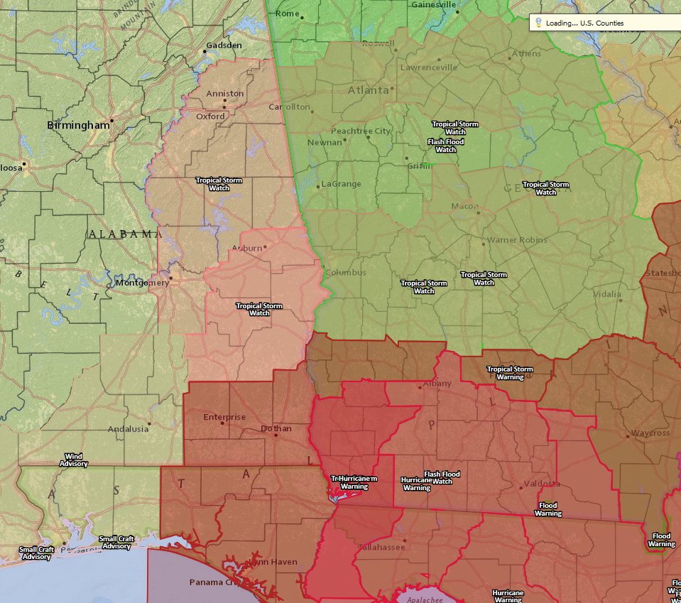
They have expanded the Tropical Storm Watch to include much of East Central Alabama. I don’t recall a Tropical Storm Watch or Warning every being issued for Central Alabama. Storms like Opal in 1995 and Ivan in 2004 certainly would have warranted one. High wind warnings were probably used back then.
Scott Martin is working on an excellent post right now about Irma’s impact across Central Alabama.
Here is the text of the statement:
HLSBMX
ALZ019-021-027>029-036>038-043>050-101230-
Hurricane Irma Local Statement Advisory Number 44
National Weather Service Birmingham AL AL112017
1120 PM CDT Sat Sep 9 2017
This product covers CENTRAL ALABAMA
**Tropical Storm Watch Now in Effect for Much of the Eastern Half of
Central Alabama**
NEW INFORMATION
—————
* CHANGES TO WATCHES AND WARNINGS:
– A Tropical Storm Watch has been issued for Calhoun, Chambers,
Clay, Cleburne, Coosa, Elmore, Montgomery, Randolph, Talladega,
and Tallapoosa
* CURRENT WATCHES AND WARNINGS:
– A Tropical Storm Watch is in effect for Barbour, Bullock,
Calhoun, Chambers, Clay, Cleburne, Coosa, Elmore, Lee, Macon,
Montgomery, Pike, Randolph, Russell, Talladega, and Tallapoosa
* STORM INFORMATION:
– About 780 miles south-southeast of Birmingham AL or about 690
miles south-southeast of Montgomery AL
– 23.5N 81.0W
– Storm Intensity 120 mph
– Movement Northwest or 305 degrees at 6 mph
SITUATION OVERVIEW
——————
Irma is expected to have noticable impacts across most of the eastern
half of Central Alabama along and generally east of Jacksonville to
Sylacauga to Montgomery to Troy line. Scattered tree and power line
damage along with some structure damage with power outages are
possible. Winds of at least 35 MPH may begin as early as the pre dawn
hours Monday in the southeast counties, but the worst conditions will
be during the day and evening on Monday as winds spread northward
across more of the area with wind gusts well above tropical storm force
possible. Such winds could bring down large tree limbs, trees, and
power lines, leading to power outages and possibly impassable roads.
The strongest winds are likely to be east of a Mount Cheaha to
Alexander City to Troy line. Conditions will gradually improve on
Tuesday as Irma continues to weaken and move to the north.
POTENTIAL IMPACTS
—————–
* WIND:
Prepare for dangerous wind having possible significant impacts mainly
east of a Mount Cheaha to Alexander City to Troy line. Potential
impacts in this area include:
– Some damage to roofing and siding materials, along with damage
to porches, awnings, carports, and sheds. A few buildings
experiencing window, door, and garage door failures. Mobile
homes damaged, especially if unanchored. Unsecured lightweight
objects become dangerous projectiles.
– Several large trees snapped or uprooted, but with greater
numbers in places where trees are shallow rooted. Several
fences and roadway signs blown over.
– Some roads impassable from large debris, and more within urban
or heavily wooded places. A few bridges, causeways, and access
routes impassable.
– Scattered power and communications outages, but more prevalent
in areas with above ground lines.
Also, prepare for hazardous wind having possible limited impacts
west of Mount Cheaha to Alexander City to Troy line and east of a
Jacksonville to Sylacauga to Montgomery line.
* FLOODING RAIN:
Prepare for locally hazardous rainfall flooding having possible
limited impacts across CENTRAL ALABAMA. Potential impacts include:
– Flood waters can enter a few structures, especially in usually
vulnerable spots. A few places where rapid ponding of water
occurs at underpasses, low-lying spots, and poor drainage
areas. Several storm drains and retention ponds become
near-full and begin to overflow. Some brief road and bridge
closures.
* TORNADOES:
Little to no impacts are anticipated at this time across CENTRAL
ALABAMA.
PRECAUTIONARY/PREPAREDNESS ACTIONS
———————————-
* EVACUATIONS:
WATCH/WARNING PHASE – For those not under evacuation orders,
understand that there are inherent risks to evacuation (such as
traffic congestion, accidents, and driving in bad weather), so
evacuate only if necessary. Help keep roadways open for those that
are under evacuation orders.
WATCH/WARNING PHASE – If you are exceptionally vulnerable to wind or
water hazards from tropical systems, consider voluntary evacuation,
especially if being officially recommended. Relocate to a
predetermined shelter or safe destination.
* OTHER PREPAREDNESS INFORMATION:
Now is the time to check your emergency plan and take necessary
actions to secure your home or business. Deliberate efforts should be
underway to protect life and property. Ensure that your Emergency
Supplies Kit is stocked and ready.
When making safety and preparedness decisions, do not focus on the
exact forecast track as there are inherent forecast uncertainties
which must be taken into account.
If you live in a place that is particularly vulnerable to high wind,
such as a mobile home, an upper floor of a high rise building, or on
a boat, plan to move to safe shelter. Take enough supplies for you
and your family for several days.
If you live in a place particularly vulnerable to flooding, such as
near the ocean or a large inland lake, in a low lying or poor
drainage area, in a valley or canyon, or near an already swollen
river, plan to move to safe shelter on higher ground
Always heed the advice of local officials and comply with any orders
that are issued. Do not needlessly jeopardize your life or the lives
of others.
When securing your property, outside preparations should be conducted
as soon as possible before conditions deteriorate. The onset of
strong gusty winds and heavy rain can cause certain preparedness
activities to become unsafe.
Be sure to let friends and other family members know of your
intentions and whereabouts for surviving the storm. For emergency
purposes, have someone located away from the threatened area serve as
your point of contact. Share vital contact information with others.
Keep cell phones handy and well charged.
Be a Good Samaritan and check on those who may not be fully aware of
the situation or who are unable to make personal preparations.
Visitors to the area should become familiar with nearby surroundings.
If you are a visitor, know the name of the county or parish in which
you are located and where it is relative to current watches and
warnings. If staying at a hotel, ask the management staff about their
on site disaster plan. Listen for evacuation orders, especially
pertaining to area visitors.
Closely monitor NOAA Weather Radio or other local news outlets for
official storm information. Listen for possible changes to the
forecast.
* ADDITIONAL SOURCES OF INFORMATION:
– For information on appropriate preparations see ready.gov
– For information on creating an emergency plan see getagameplan.org
– For additional disaster preparedness information see redcross.org
NEXT UPDATE
———–
The next local statement will be issued by the National Weather
Service in Birmingham AL around 5 AM CDT, or sooner if conditions
warrant.
$$
Category: Alabama's Weather, ALL POSTS
About the Author (Author Profile)
Bill Murray is the President of The Weather Factory. He is the site's official weather historian and a weekend forecaster. He also anchors the site's severe weather coverage. Bill Murray is the proud holder of National Weather Association Digital Seal #0001 @wxhistorianSubscribe
If you enjoyed this article, subscribe to receive more just like it.


