Update On Irma’s Impact On Alabama
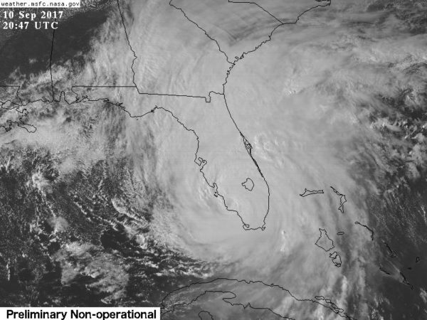
Hurricane Irma made a second landfall with 115 mph sustained winds (with higher gusts) at Marco Island, Florida earlier today. The airport at Naples, Florida reported a wind gust of 142 mph.
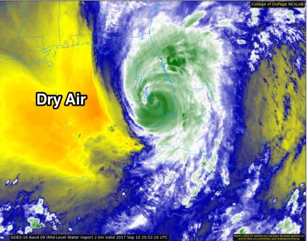
On the positive side, dry air to the west of the hurricane, and shear associated with an upper trough (the feature that turned the storm to the north) are getting involved, and slow weakening is likely from here on, but understand this remains a very dangerous hurricane that will impact Tampa/St. Petersburg/Orlando tonight, along with much of the Florida Peninsula.
Late this afternoon Irma has sustained winds of 110 mph, with a central pressure of 938 mb. The center is expected to remain over land, moving over far West Florida tonight, then into Southwest Georgia and East Alabama as a weakening tropical storm tomorrow and tomorrow night.
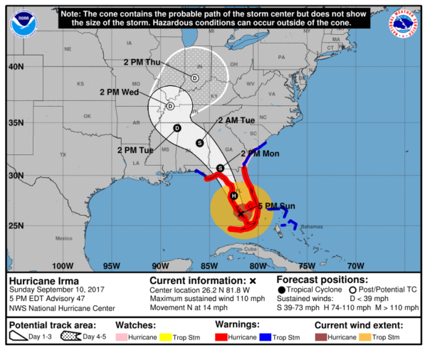
THE ALABAMA IMPACT: A tropical storm warning remains in effect for parts of East and Southeast Alabama tomorrow and tomorrow night; a tropical storm watch is in effect for parts of Northeast Alabama.
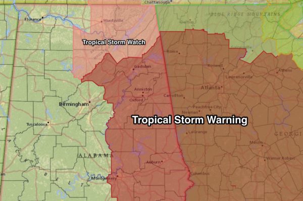
The tropical storm warning does not include Birmingham or Tuscaloosa. It does include places like Gadsden, Anniston, Alexander City, Auburn, Opelika, Montgomery, and Dothan.
We also note the NWS has issued a wind advisory for tomorrow.. for that part of Alabama not in the tropical storm warning.
TIMING: With Irma showing a littler faster forward speed, it now looks like the main window for rain and stronger winds will come from 6:00 a.m. tomorrow through 6:00 a.m. Tuesday. Looks now like we will see clearing during the day Tuesday with winds slowly calming down.
WIND SPEEDS: Winds over East Alabama in the tropical storm warning tomorrow and tomorrow night will be in the 30-45 mph range, with higher gusts, especially on ridges. Winds for the western half of the state will average 20-30 mph.
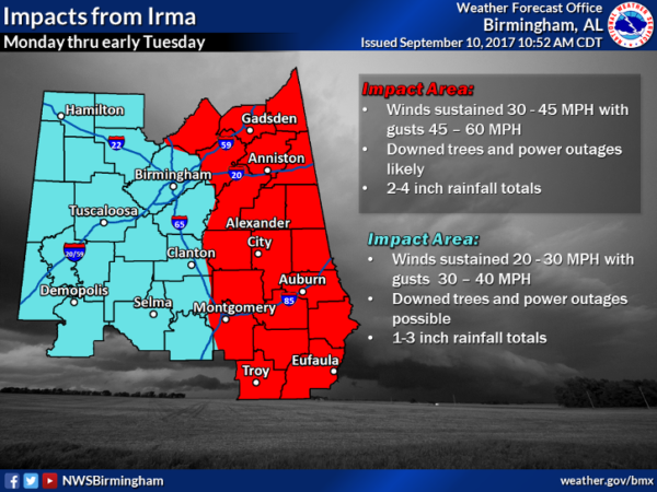
These winds will be high enough to knock down trees and power lines, especially over the eastern half of the state in the tropical storm warning. Some power outages are likely.
RAIN: Rain amounts of 2-4″ are possible over the eastern counties (in the tropical storm warning), with amounts of 1-2″ for the western counties. Some flooding is possible, but Irma’s remnant circulation will be moving along at a good clip, reducing the chance of major problems.
GULF COAST: Latest NHC track keeps the center of Irma well east of Panama City Beach, and east of Tallahassee. This keeps places like Gulf Shores, Pensacola, Navarre Beach, Destin, and Panama City Beach on the “good” west side of the circulation. Just some light rain and a gusty north wind from Gulf Shores to Destin.
Panama City Beach will be windy and wet tonight and tomorrow, but it is an offshore flow with no storm surge. The rest of the week will feature very nice weather on the coast with mostly sunny days and fair nights.
CLOSINGS: See the ABC 33/40 page here for school/business/government closings.
Keep an eye on the blog for updates!
Category: Alabama's Weather, ALL POSTS
About the Author (Author Profile)
James Spann is one of the most recognized and trusted television meteorologists in the industry. He holds the AMS CCM designation and television seals from the AMS and NWA. He is a past winner of the Broadcast Meteorologist of the Year from both professional organizations.Subscribe
If you enjoyed this article, subscribe to receive more just like it.


