Warm Days For Alabama; Tropics Remain Active
SUMMER HANGING ON: The “official” end of summer is four days away; it happens at 3:02p CT Friday when the sun is directly over the equator, the autumnal equinox. We have some fairly routine late summer weather this week with warm afternoons, high humidity, and the risk of “scattered, mostly afternoon and evening showers and thunderstorms”.
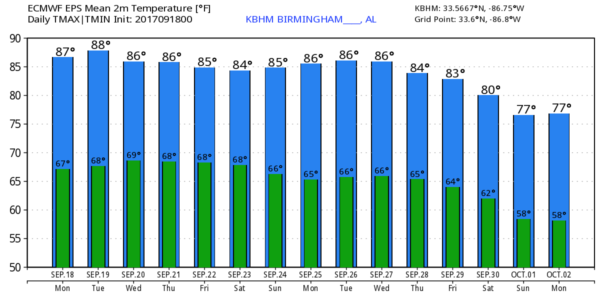
Showers/storms will be most numerous over the southern half of the state today and tomorrow; a decent part of North Alabama will be dry over the next 48 hours. Highs today and tomorrow will be in the 87-90 degree range.
Scattered showers and thunderstorms will increase statewide Wednesday through Friday as moisture deepens. The best chance of showers will be from about 12:00 noon through 8:00 p.m… otherwise we will forecast a mix of sun and clouds with a high in the mid to upper 80s.
THE ALABAMA WEEKEND: Warm, humid weather continues thanks an upper ridge; expect a partly sunny sky Saturday and Sunday with the continued threat of “scattered, mostly afternoon and evening showers and thunderstorms”. Highs over the weekend will be in the mid 80s.
NEXT WEEK: Not much change for the first half of the week, but medium range model guidance suggests we should get into some cooler, drier continental air in about 10-15 days as we get into October.
TROPICS: Out in the eastern Atlantic, Lee is a tropical depression that is in the process of becoming a remnant low. No worries there.
Closer in, we have Jose and Maria to discuss.
JOSE: Jose doesn’t look especially healthy on satellite images this morning; it is 270 miles east/southeast of Cape Hatteras, NC, and is packing sustained winds of 85 mph. While the center is expected to remain offshore, it will bring potential for tropical storm force (39 mph or higher) winds to the upper Atlantic coast through mid-week, along with dangerous surf and rip currents…
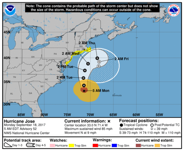
A tropical storm warning is in effect from Fenwick Island, DE to Cape Cod, MA.
MARIA: Hurricane Maria continues to grow stronger; it is now packing sustained winds of 110 mph, and is currently about 85 miles east of Martinique in the Leeward Islands. Maria is expected to be a major hurricane (category three or higher) very close to Puerto Rico Wednesday.
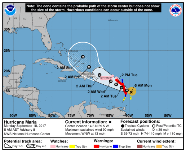
The hurricane will begin to gain latitude later this week, and confidence is high that it will not enter the Gulf of Mexico. For now it is too early to determine the threat to the Bahamas or the U.S. East Coast.
Interesting to note there is a chance that Maria could impact Jose (if it is still around) in 5-10 days off the U.S. Atlantic coast, with potential for the Fujiwhara effect… a case where they would orbit cyclonically (counterclockwise) about a point between the two systems.
See the Weather Xtreme video for maps, graphics, and more details.
BEACH FORECAST: Click here to see the AlabamaWx Beach Forecast Center page. The Beach Forecast is partially underwritten by the support of Brett/Robinson Vacation Rentals in Gulf Shores and Orange Beach. Click here to see Brett/Robinson’s Hot Deals now!
WEATHER BRAINS: Don’t forget you can listen to our weekly 90 minute netcast anytime on the web, or on iTunes. This is the show all about weather featuring many familiar voices, including our meteorologists here at ABC 33/40. We will produce this week’s show tonight at 8:30p CT… you can watch it live here.
CONNECT: You can find me on all of the major social networks…
Facebook
Twitter
Google Plus
Instagram
Pinterest
Snapchat: spannwx
I have a weather program this morning at Deer Valley Elementary in Hoover… look for the next Weather Xtreme video here by 4:00 this afternoon. Enjoy the day!
Category: Alabama's Weather, ALL POSTS, Weather Xtreme Videos
About the Author (Author Profile)
James Spann is one of the most recognized and trusted television meteorologists in the industry. He holds the AMS CCM designation and television seals from the AMS and NWA. He is a past winner of the Broadcast Meteorologist of the Year from both professional organizations.Subscribe
If you enjoyed this article, subscribe to receive more just like it.


