Warm, Muggy Days; A Few Afternoon Storms
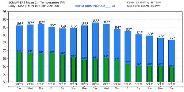
TYPICAL LATE SUMMER WEATHER CONTINUES: An upper ridge will stay over Alabama for the next 7-10 days, meaning this classic late summer weather will continue. We project a high today in the 87 to 90 degree range with a partly sunny sky. A few showers and storms will form this afternoon and early tonight; they will be random and scattered… the chance of any one spot getting wet is about one in four.
That is pretty much the case of the rest of the week. Models have actually trended toward fewer afternoon showers due to the warm air aloft associated with the ridge… we are forecasting partly to mostly sunny days, fair nights, and highs holding in that 87 to 90 degree range. Showers will come between 2 and 7 p.m… but they will be isolated. Widespread rain is not expected.
THE ALABAMA WEEKEND: No real change. Highs well up in the 80s Saturday and Sunday with only isolated afternoon and evening showers and storms. The chance of any one place getting wet will be in the 20 percent category.
FOOTBALL WEATHER: For Friday night’s high school games, it will be warm and humid with temperatures falling from the low 80s at kickoff, into the upper 70s by the final whistle. Just a slight risk of a shower during the first quarter.
Alabama will be in Nashville Saturday to take on the Vanderbilt Commodores (2:30p CT kickoff)… the sky will be mostly sunny with a kickoff temperature near 88 degrees… falling into the mid 80s by the fourth quarter. Just a small risk of a brief shower.
Auburn is also on the road; they play Missouri in Columbia Saturday evening (6:30p CT kickoff)… we expect a clear sky with temperatures falling from 84 degrees at kickoff into the upper 70s by the final whistle.
And, UAB is also traveling this weekend; they play North Texas Saturday evening (5:30p CT kickoff) in Denton. The weather will be dry with a fair sky; about 90 degrees at kickoff, falling through the 80s during the game.
NEXT WEEK: The ridge holds, so we stay warm with highs well up in the 80s and only isolated afternoon showers. No sign of any major, widespread rain for the state for the next 7 to 10 days.
TROPICS: Lee is now a remnant low in the Central Atlantic. We are down to two active systems…
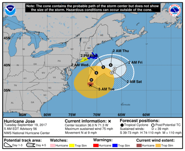
JOSE: Jose is still hanging on as a hurricane off the U.S. Atlantic coast with sustained winds of 75 mph; it is expected to weaken to a tropical storm tonight. The center will remain offshore, but it is close enough to warrant a tropical storm warning for Cape Cod. It will loop well east of New England over the next few days, and will lose tropical characteristics late this week.
MARIA: This is an extremely dangerous category five hurricane; the eye went right over the island of Dominica last night. Maximum sustained winds are near 160 mph with higher gusts. Some fluctuations in intensity are likely during the next day or two, but Maria is forecast to remain an extremely dangerous category 4 or 5 hurricane while it approaches the Virgin Islands and Puerto Rico.
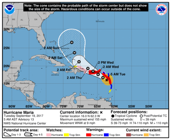
A Hurricane Warning is in effect for…
* Guadeloupe
* Dominica
* St. Kitts, Nevis, and Montserrat
* U.S. Virgin Islands
* British Virgin Islands
* Puerto Rico, Culebra, and Vieques
Maria will begin to gain latitude later this week, and is expected to turn northward east of the Bahamas. Confidence is growing that Maria will not directly impact the East Coast of the U.S., and it is no threat to the Gulf of Mexico.
BEACH FORECAST: Click here to see the AlabamaWx Beach Forecast Center page. The Beach Forecast is partially underwritten by the support of Brett/Robinson Vacation Rentals in Gulf Shores and Orange Beach. Click here to see Brett/Robinson’s Hot Deals now!
WEATHER BRAINS: Don’t forget you can listen to our weekly 90 minute netcast anytime on the web, or on iTunes. This is the show all about weather featuring many familiar voices, including our meteorologists here at ABC 33/40.
CONNECT: You can find me on all of the major social networks…
Facebook
Twitter
Google Plus
Instagram
Pinterest
Snapchat: spannwx
I am speaking to a senior adult group in Fayette this morning… look for the next Weather Xtreme video here by 4:00 this afternoon. Enjoy the day!
Category: Alabama's Weather, ALL POSTS, Weather Xtreme Videos
About the Author (Author Profile)
James Spann is one of the most recognized and trusted television meteorologists in the industry. He holds the AMS CCM designation and television seals from the AMS and NWA. He is a past winner of the Broadcast Meteorologist of the Year from both professional organizations.Subscribe
If you enjoyed this article, subscribe to receive more just like it.


