

A Few Showers Popping Up At Midday In Central Alabama
RADAR CHECK AT 12:05 PM
While most of Central Alabama is dry at this point on the first Monday in the fall season, a few very small showers are starting to dot the radar in the area. Some of these may not even be reaching the ground.

SATELLITE CHECK
Skies across the state at this time is partly cloudy for the most part, with a few spots in the southern parts of the state enjoying maximum sunshine.

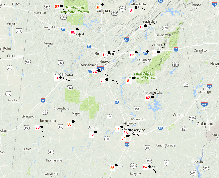
TEMPERATURES
We are currently running in the lower to mid-80s at this point throughout Central Alabama, with the cloud cover holding back the temperatures at this point. Birmingham is currently at 84 degrees, while Montgomery is currently the warm spot at 86 degrees. Marion is the cool spot at 80 degrees, who may have had one of those small showers pass over or just nearby.
FOR THE REST OF YOUR MONDAY
We’ll continue to have partly cloudy skies throughout Central Alabama for the remainder of the afternoon and into the early evening hours. We’ll mention a very slight risk of isolated showers throughout the area, with a slightly better risk of scattered showers and storms in the extreme southwestern part of the area. Afternoon highs will be in the upper 80s to at or just above 90 degrees. Shower chances will diminish as we lose daylight, and the skies will begin to clear out. We’ll be dry throughout the late night and overnight hours, with lows dipping into the mid to upper 60s for most.
A HOT AND DRY TUESDAY IN STORE FOR CENTRAL ALABAMA
Need I say more… We’ll have mostly clear skies throughout the daytime hours along with slightly lower dewpoint levels. No rain is expected throughout the day, with afternoon highs will be in the upper 80s to the lower 90s, and dewpoints in the mid 60s. A clear and fair night for Tuesday night, with overnight lows in the mid to upper 60s.
HURRICANE MARIA
Maria continues to move slowly to the north, creating large swells that are affecting much of the U.S. Atlantic Coast. Maximum sustained winds are at 80 MPH, and weakening is expected to continue throughout the next two days before she makes a hard right and exits out to open sea. Tropical storm watches and warnings are up for much of the North Carolina coast as storm surge of up to 2-4 feet, along with tropical storm force winds and dangerous rip currents.

HURRICANE LEE
Lee is a very small and compact hurricane with maximum sustained winds at 90 MPH. Lee is currently moving to the south-southwest at 2 MPH, but is expected to loop all the way back around to the northeast by Thursday and head out to the open sea. No threat to land at all.

OUR TROPICAL WEATHER CATEGORY HAS THE LATEST ON ALL ACTIVE STORMS
Stay up-to-date with the latest updates on all of the tropical systems out in the Atlantic Ocean, Caribbean Sea, or in the Gulf of Mexico with the latest posts in our Tropical Weather section. Click here to see the latest.
GOT BEACH PLANS?
Be sure to keep up to date with the detailed forecasts from Fort Morgan over to Panama City Beach with the AlabamaWx Weather Blog. Click here to see the AlabamaWx Beach Forecast Center page.
The Beach Forecast is partially underwritten by the support of Brett/Robinson Vacation Rentals in Gulf Shores and Orange Beach. Click here to see Brett/Robinson’s Hot Deals now!
WEATHERBRAINS
Check out the show at www.WeatherBrains.com. You can also subscribe on iTunes. You can watch the show live at live.bigbrainsmedia.com on Monday nights starting at 8:30 PM CDT. You will be able to see the show on the James Spann 24×7 weather channel on cable or directly over the air on the dot 2 feed.
Category: Alabama's Weather, ALL POSTS
About the Author (Author Profile)
Scott Martin is an operational meteorologist, professional graphic artist, musician, husband, and father. Not only is Scott a member of the National Weather Association, but he is also the Central Alabama Chapter of the NWA president. Scott is also the co-founder of Racecast Weather, which provides forecasts for many racing series across the USA. He also supplies forecasts for the BassMaster Elite Series events including the BassMaster Classic.Subscribe
If you enjoyed this article, subscribe to receive more just like it.


