

Dry Pattern Continues; Cooler By Friday
RADAR CHECK: Most of the showers on radar this afternoon are over the southwest counties of the state, moving slowly to the northwest. The northern counties are dry with a partly sunny sky.

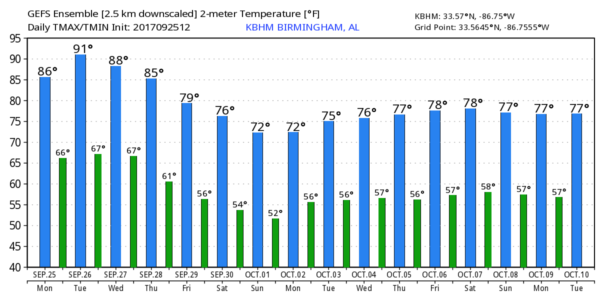
Temperatures are mostly in the mid 80s; the average high for Birmingham on September 25 is 82.
REST OF THE WEEK: It will feel more like summer tomorrow and Wednesday, with a good supply of sunshine both days we project a high close to 90 degrees. About 8 degrees above average, but not close to the records…
September 26 record high for Birmingham is 95 set in 1897
September 27 record high for Birmingham is 94 set in 1998
The weather stays dry Thursday and Friday, but temperatures trend downward with a high in the mid 80s Thursday, and close to 80 degrees Friday as the upper ridge breaks down.
THE ALABAMA WEEKEND: Very nice weather continues with sunny pleasant days and clear cool nights. Highs will be in the 77-80 degree range, with lows in the 50s. Some of the cooler pockets could see upper 40s early Saturday morning.
FOOTBALL WEATHER: Perfect weather conditions for the high school games Friday night; clear with temperatures falling from 76 at kickoff, into the mid 60s by the fourth quarter.
Auburn hosts Mississippi State Saturday at Jordan-Hare Stadium (5:00p CT kickoff)… the sky will be clear with temperatures falling from 78 degrees at the start of the game, to near 68 by the final whistle.
Alabama will host the Ole Miss Rebels Saturday night in Tuscaloosa (8:00p CT kickoff)… with a clear sky, temperatures will fall from near 74 at kickoff, into the low 60s by the fourth quarter.
NEXT WEEK: Dry, pleasant weather continues at least for the first half of the week with highs around 80, and lows around 60. Moisture will return later in the week, but prospects for a big rain event look rather low. Keep in mind October is usually out driest month of the year in Alabama.
TROPICS: Hurricane Lee will remain over the open Atlantic, and is no threat to land. Hurricane Maria will pass just east of the North Carolina Outer Banks tomorrow and Wednesday. It is now packing sustained winds of 80 mph, and will be close enough for tropical storm force winds (39 mph or higher) to impact the Outer Banks. It will move east/northeast, out to sea, later this week.
The rest of the Atlantic basin, including the Gulf of Mexico, is very quiet for now.
BEACH FORECAST: Click here to see the AlabamaWx Beach Forecast Center page. The Beach Forecast is partially underwritten by the support of Brett/Robinson Vacation Rentals in Gulf Shores and Orange Beach. Click here to see Brett/Robinson’s Hot Deals now!
WEATHER BRAINS: Don’t forget you can listen to our weekly 90 minute netcast anytime on the web, or on iTunes. This is the show all about weather featuring many familiar voices, including our meteorologists here at ABC 33/40. We will produce this week’s show tonight at 8:30p CT… you can watch it live here.
CONNECT: You can find me on all of the major social networks…
Facebook
Twitter
Google Plus
Instagram
Pinterest
Snapchat: spannwx
I had a great time today visiting with the Pickens County HeadStart students in Carrollton… be looking for them on the Pepsi KIDCAM on ABC 33/40 News at 5:00 this afternoon! The next Weather Xtreme video will be posted here by 7:00 a.m. tomorrow…
Category: Alabama's Weather, ALL POSTS, Weather Xtreme Videos
About the Author (Author Profile)
James Spann is one of the most recognized and trusted television meteorologists in the industry. He holds the AMS CCM designation and television seals from the AMS and NWA. He is a past winner of the Broadcast Meteorologist of the Year from both professional organizations.Subscribe
If you enjoyed this article, subscribe to receive more just like it.


