Cool Day; Some Scattered Light Rain
CLOUDS; NOT MUCH RAIN: A cool easterly flow will set up across Alabama today, meaning a mostly cloudy and cool day with highs only in the low to mid 70s for most places; some East Alabama communities could hold in the 60s all day. The average high for October 1 (for Birmingham) is 80 degrees.
We will mention the chance of a little scattered light rain, but most places will be dry.
REST OF THE WEEK: A high amplitude pattern will persist this week with a cold upper trough over the western states (where there will be lots of mountain snow), and a warm ridge over the eastern half of the nation. For Alabama, we project mostly sunny warm days and fair, pleasant nights tomorrow through Friday. Highs will be mostly in the mid 80s, with lows in the low to mid 60s.
THE ALABAMA WEEKEND: Not much change; warm, dry weather persists across the Deep South with a good supply of sunshine Saturday and Sunday. Highs will be in the mid 80s, lows in the mid 60s… about 5-7 degrees above average.
NEXT WEEK: The upper trough over the eastern states will move eastward, and a cold front should move through by the middle of the week, mostly in dry fashion. Then, much cooler air should follow toward the end of the week.
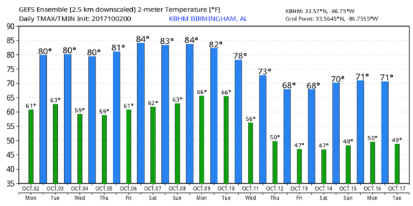
DRY DAYS: Today will be the 13th consecutive day with no measurable rain at Birmingham, and we see no really significant rain over the next 7 to 10 days. But, understand October is our driest month of the year, and long dry spells are to be expected this time of the year. We note the rain surplus for the year (at Birmingham) is 16.94″. Most other cities around the state have had a very wet year through mid-September.
November/December is our late fall severe weather season, and typically when numerous showers and storms return.
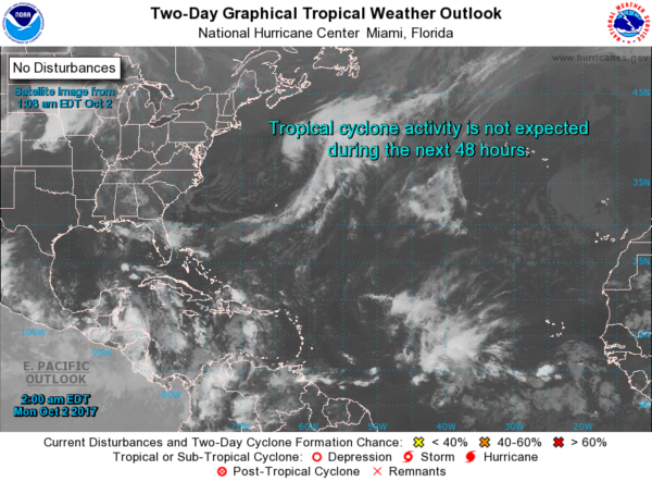
TROPICS: All is quiet across the Atlantic basin this morning. Global models continue to hint at potential tropical action over the far southern Gulf of Mexico or Northwest Caribbean in 5-10 days, but if anything tries to form there, most likely it will be pulled northeast and won’t impact our state. See the Weather Xtreme video for maps, graphics, and more details.
BEACH FORECAST: Click here to see the AlabamaWx Beach Forecast Center page. The Beach Forecast is partially underwritten by the support of Brett/Robinson Vacation Rentals in Gulf Shores and Orange Beach. Click here to see Brett/Robinson’s Hot Deals now!
WEATHER BRAINS: Don’t forget you can listen to our weekly 90 minute netcast anytime on the web, or on iTunes. This is the show all about weather featuring many familiar voices, including our meteorologists here at ABC 33/40. We will produce this week’s show tonight at 8:30p CT… you can watch it live here.
CONNECT: You can find me on all of the major social networks…
Facebook
Twitter
Google Plus
Instagram
Pinterest
Snapchat: spannwx
I have a weather program this morning at Westminster School at Oak Mountain… look for the next Weather Xtreme video here by 4:00 this afternoon. Enjoy the day!
Category: Alabama's Weather, ALL POSTS, Weather Xtreme Videos
About the Author (Author Profile)
James Spann is one of the most recognized and trusted television meteorologists in the industry. He holds the AMS CCM designation and television seals from the AMS and NWA. He is a past winner of the Broadcast Meteorologist of the Year from both professional organizations.Subscribe
If you enjoyed this article, subscribe to receive more just like it.


