Tropical Trouble Brewing To The South
DRY THROUGH FRIDAY: An upper ridge will keep Alabama dry through Friday with mostly sunny warm days and fair cool nights. Highs in the mid 80s tomorrow and Friday; lows in the upper 50s and low 60s for most places. Beyond Friday; our weather will be determined by a tropical system in the Gulf of Mexico.
TD 16: Tropical Depression 16 is expected to become Tropical Storm Nate during the next 12 hours, and possibly reach hurricane strength by the time it reaches the Gulf Coast Sunday or Sunday night. Here are some important points…
*This is a new system, and until we get better data from hurricane hunters and research aircraft in the area confidence in the forecast track and intensity will remain fairly low. And don’t focus on the exact forecast track, especially at the longer ranges, since the average NHC track errors are about 175 and 225 statute miles at days 4 and 5, respectively.
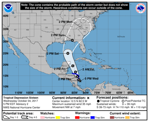
*For now, NHC is forecasting “Nate” to be a category one hurricane at the time of landfall Sunday.
*If you have a trip planned this weekend to the Gulf Coast, it is simply too early to know the conditions at any specific point. For now, based on the current NHC forecast, highest impact would seem to be from Fort Walton Beach eastward to Destin, Panama City Beach, and Cape San Blas Saturday night and Sunday. The Alabama Gulf Coast would be on the “good” side of the storm. But, it is very important to note that this forecast can, and probably will change over the next few days.
If it was me, I would wait until tomorrow (when forecast confidence will be higher) before changing travel plans.
*Remember, the “bad” side of the system is east of the circulation center. This is where most of the storm surge/flooding issues will be found as “Nate” approaches the coast and moves inland. On the “good” west side, no storm surge issues, although there will be some wind and rain.
*”Nate” will be long gone by the National Shrimp Festival in Gulf Shores October 12-15.
*On the current forecast track from NHC, much of Alabama will be on the “good” west side of the circulation. Rain and wind will be possible, if not likely, for the eastern counties of the state Sunday and Monday, but the really big rains will be to the east over Georgia and South Carolina. Again, this could change.
*Concerning Orlando, Tampa, Daytona Beach, and the Florida Peninsula, there will be some wind and rain Sunday, but the main impact will be to the west based on the current forecast.
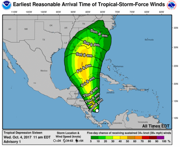
THE ALABAMA WEEKEND: We will forecast a partly sunny sky Saturday with a few showers possible, but a decent part of the day should be dry and warm with a high in the mid 80s. Then, clouds increase Saturday night, and Sunday will be mostly cloudy and breezy with rain chances increasing, especially over the eastern counties of the state. But understand our weekend forecast can, and probably will change as we get better clarity on “Nate”.
FOOTBALL WEATHER: For the high school games Friday night, the sky should be clear with temperatures falling from around 80 degrees at kickoff, through the 70s during the game.
Auburn hosts Ole Miss Saturday at Jordan-Hare Stadium (11:00a CT kickoff)… the sky will be partly sunny with temperatures rising from near 78 degrees at kickoff into the low 80s by the final whistle. A few widely scattered showers are possible.
Alabama is on the road; they will take on the Texas A&M Aggies Saturday in College Station, Texas Saturday evening (6:15p CT kickoff). The sky will be clear with temperatures falling from near 88 degrees at kickoff, to near 80 by the end of the game.
UAB’s homecoming is Saturday; the Blazers take on Louisiana Tech at Legion Field (3:00p CT kickoff)… for now we are forecasting a partly sunny sky with only widely scattered showers. About 83 degrees at kickoff, falling to near 80 by the fourth quarter.
Please keep in mind the forecast for the Auburn and UAB is subject to change due to the tropical system in the Gulf of Mexico.
NEXT WEEK: We will maintain a chance of rain Monday, with the highest coverage over the eastern half of the state, then the rest of the week looks calm with a gradual cooling trend.
BEACH FORECAST: Click here to see the AlabamaWx Beach Forecast Center page. The Beach Forecast is partially underwritten by the support of Brett/Robinson Vacation Rentals in Gulf Shores and Orange Beach. Click here to see Brett/Robinson’s Hot Deals now!
WEATHER BRAINS: Don’t forget you can listen to our weekly 90 minute netcast anytime on the web, or on iTunes. This is the show all about weather featuring many familiar voices, including our meteorologists here at ABC 33/40.
CONNECT: You can find me on all of the major social networks…
Facebook
Twitter
Google Plus
Instagram
Pinterest
Snapchat: spannwx
Look for the next Weather Xtreme video here by 7:00 a.m. tomorrow…
Category: Alabama's Weather, ALL POSTS, Weather Xtreme Videos
About the Author (Author Profile)
James Spann is one of the most recognized and trusted television meteorologists in the industry. He holds the AMS CCM designation and television seals from the AMS and NWA. He is a past winner of the Broadcast Meteorologist of the Year from both professional organizations.Subscribe
If you enjoyed this article, subscribe to receive more just like it.


