

Great Weather At Midday As Our Focus Starts To Turn To Nate
At 12:30 PM, we have beautiful cobalt blue skies and sunshine out across Central Alabama without any clouds out there to dim out the brightness of this wonderful day. The good news is that we will keep these conditions for the rest of the afternoon hours today and throughout the day on Friday. After that, it looks like we will have to be dealing with Nate. More on him in a minute.
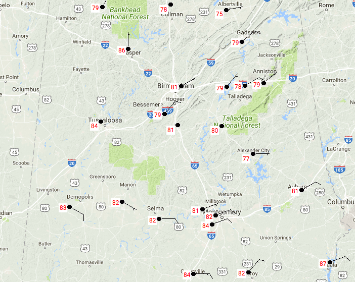
Temperatures are currently running throughout the upper 70s and into the mid-80s throughout Central Alabama, with the only reporting station in the upper 80s at this time is Eufaula at 87 degrees. Birmingham is currently at 81 degrees.
FOR THE REST OF YOUR THURSDAY
As mentioned earlier in the post, we’ll continue to have mainly clear skies throughout Central Alabama for the remainder of the afternoon and early evening hours. Afternoon highs will top out in the 80s throughout Central Alabama, with the warmer temperatures in the southern parts of the area. Skies will remain mostly clear throughout the late night and overnight hours, with lows dropping into the upper 50s to the mid-60s.
ANOTHER FINE AND WARM DAY TO END THE WORK WEEK
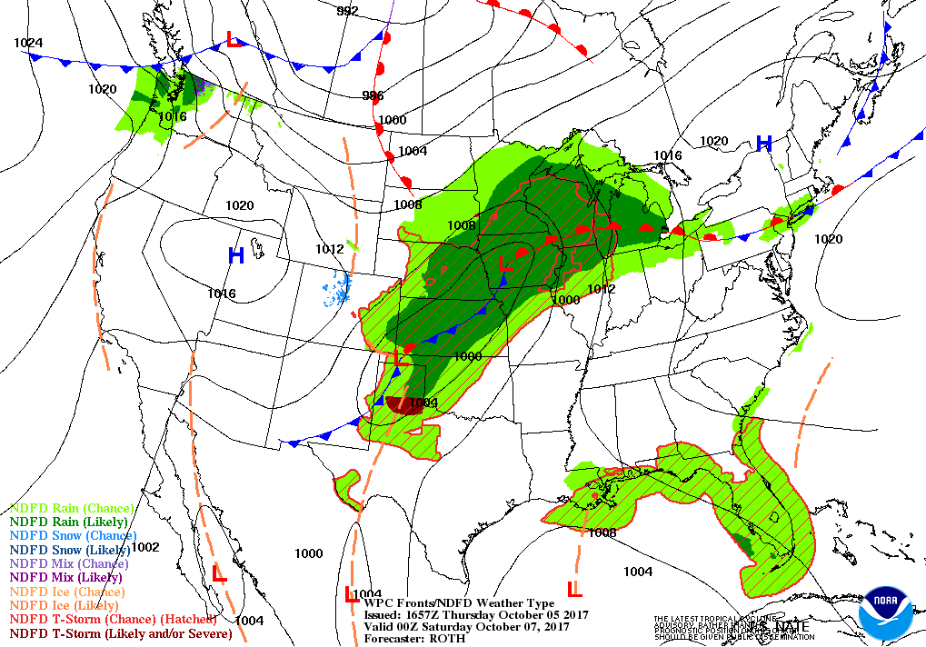
Mostly sunny skies can be expected throughout the entire day across Central Alabama for Friday, even though the clouds will start to increase as Nate starts to get closer to the Gulf Coast. Afternoon highs will be up in the mid to upper 80s across Central Alabama. Clouds will continue to be on the increase throughout the late night and overnight hours, and we could have a shower or two out there just before day break. Lows will be in the 60s.
HIGH SCHOOL FOOTBALL GAMES
No rain worries for tomorrow evening, even though cloud cover will start to increase through the late evening hours. Temperatures will start off mainly in the 70s at kickoff and dropping into the mid-60s to the lower 70s by the final whistle.
WHAT’S UP WITH TROPICAL STORM NATE
Latest update from the National Hurricane Center has the maximum sustained winds at 40 MPH with movement to the northwest at 9 MPH. Latest projected path has Nate continuing to move northwest from now until very late on Saturday or very early Sunday morning before it starts to change direction to the northeast as landfall is made on Sunday morning close to New Orleans as a category 1 hurricane. During the day on Sunday, Nate will make his way across Alabama while gradually weakening, with the center passing very close to the Birmingham Metropolitan Area on Sunday evening before crossing into Tennessee by early Sunday morning.
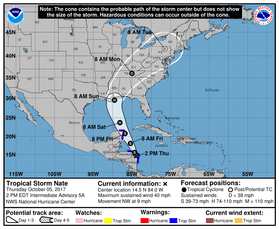
The GFS and European are pretty close in agreement with what the NHC is forecasting, with the GFS landfall just a few miles west on the central coast, but things can change and often will before landfall. At this point, we can expect heavy rain (2-4 inches) with gusty winds reaching low to mid-tropical storm force (40-50 MPH), and a few tornadoes will be possible for mainly eastern parts of the state (east of the center). Once the center passes north of your location, conditions will steadily start to improve. Good news is that Nate will not hang around and should be completely out of the area by Monday afternoon.
THE TROPICS
Stay up-to-date with the latest updates on all of the tropical systems out in the Atlantic Ocean, Caribbean Sea, or in the Gulf of Mexico with the latest posts in our Tropical Weather section. Click here to see the latest.
GULF COAST WEATHER
With the approach of Nate, conditions will start to deteriorate along the Alabama and northwest Florida Gulf Coast on early Saturday morning. Rip currents and rough surf will start to affect the coastline on Friday afternoon. Tropical storm force winds, heavy rain and a few tornadoes will be possible this weekend, before much better conditions arrive for Monday. Be sure to keep up to date with the detailed forecasts from Fort Morgan over to Panama City Beach with the AlabamaWx Weather Blog.
Click here to see the AlabamaWx Beach Forecast Center page.
The Beach Forecast is partially underwritten by the support of Brett/Robinson Vacation Rentals in Gulf Shores and Orange Beach. Click here to see Brett/Robinson’s Off Season Deals now!
ON THIS DAY IN WEATHER HISTORY
1989 – Showers and thunderstorms associated with Tropical Storm Raymond deluged southeastern Arizona with heavy rain. Up to four and a half inches of rain was reported north of Wilcox. Three- fourths of the streets in the town of Wilcox were left under eighteen inches of water, and damage exceeded a million dollars. Evening thunderstorms developing along a cold front produced severe weather in Oklahoma and the Texas panhandle. Thunderstorms produced high winds which gusted to 80 mph at White Deer TX, and resulted in one death at Pocasset OK. Thunderstorms produced golf ball size hail at Pampa TX and Lefors TX.
WEATHERBRAINS
Check out the show at www.WeatherBrains.com. You can also subscribe on iTunes. You can watch the show live at live.bigbrainsmedia.com on Monday nights starting at 8:30 PM CDT. You will be able to see the show on the James Spann 24×7 weather channel on cable or directly over the air on the dot 2 feed.
Category: Alabama's Weather, ALL POSTS
About the Author (Author Profile)
Scott Martin is an operational meteorologist, professional graphic artist, musician, husband, and father. Not only is Scott a member of the National Weather Association, but he is also the Central Alabama Chapter of the NWA president. Scott is also the co-founder of Racecast Weather, which provides forecasts for many racing series across the USA. He also supplies forecasts for the BassMaster Elite Series events including the BassMaster Classic.Subscribe
If you enjoyed this article, subscribe to receive more just like it.


