Tropical Storm Nate Headed Our Way
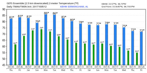
WARM OCTOBER AFTERNOON: Quite the warm-up across Alabama this afternoon. Our Skywatcher at Black Creek in Etowah County dropped to 48 degrees early this morning, but temperatures have recovered into the low to mid 80s across Alabama this afternoon with a good supply of sunshine. Tomorrow will be another warm, dry day with a high in the mid 80s for most communities.
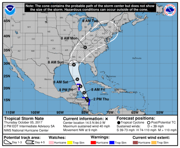
Our weekend weather will be determined by the behavior of Tropical Storm Nate, now inland over northeastern Nicaragua with 40 mph winds. Here are the important points on Nate this afternoon…
*The NHC forecast takes Nate over the tip of the Yucatan Peninsula tomorrow night, and then into the open Gulf of Mexico Saturday. Landfall is forecast Sunday morning over Southeast Louisiana as a category one hurricane. From there, the circulation center moves through South Mississippi, and into North Alabama later Sunday and Sunday night.
*Confidence is growing now that we have better model agreement. But, still, understand average NHC track errors are about 175 and 225 statute miles at days 4 and 5, respectively. Changes are still possible.
*It is also important to note that there is limited skill at tropical cyclone intensity forecasts beyond 48 hours. The good news is that models generally are showing a weaker system at the time of landfall, mostly under hurricane strength. Nate will encounter some westerly shear, cooler SSTs (sea surface temperatures) over the far northern Gulf of Mexico, and some drier air as well. I would suggest there is a reasonable chance Nate remains below hurricane strength on the journey through the Gulf of Mexico.
Confidence is very high this will not be a major hurricane, like Irma or Maria.
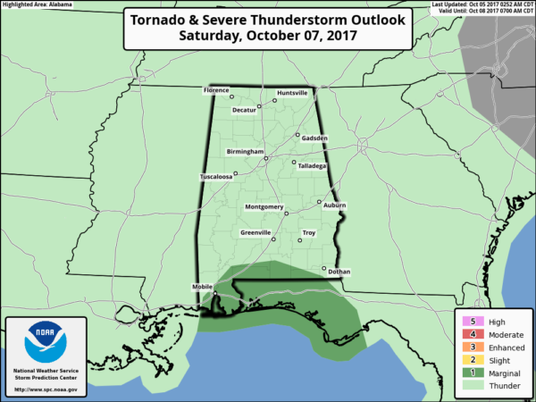
*For the Gulf Coast, from Biloxi to Gulf Shores to Pensacola to Destin to Panama City Beach, expect increasing wind and rain Saturday through Sunday morning. Understand there will be breaks in the rain, but when the rain falls, it will be heavy at times. There will also be a tornado threat on the Gulf Coast Saturday; SPC has a “marginal risk” defined.
*The weather will improve on the Gulf Coast Sunday and Monday as Nate moves inland with increasing amounts of sunshine and fewer showers. For those asking about a beach trip this weekend, I can’t make a decision for you since different people have a different tolerance level for being on the coast with wind and rain. Bottom line is that Saturday will be windy and wet at times with the threat of isolated tornadoes, followed by better weather Sunday and Monday.
*For inland parts of Alabama, most of the rain will come Saturday night and Sunday. Rain amounts of 1-2 inches are possible, with potential for isolated 3 to 4 inch amounts. Too early to forecast placement of the axis of heaviest rain. With the remnant surface low expected to pass west of here, we will have to watch for isolated tornadoes over North/Central Alabama during the day Sunday.
FOOTBALL WEATHER: For the high school games tomorrow night, the sky should be clear with temperatures falling from around 80 degrees at kickoff, through the 70s during the game.
Auburn hosts Ole Miss Saturday at Jordan-Hare Stadium (11:00a CT kickoff)… the sky will be partly sunny with temperatures rising from near 78 degrees at kickoff into the low 80s by the final whistle. A few widely scattered showers are possible, but the most widespread rain should stay south of Auburn during the game.
Alabama is on the road; they will take on the Texas A&M Aggies Saturday in College Station, Texas Saturday evening (6:15p CT kickoff). The sky will be clear with temperatures falling from near 88 degrees at kickoff, to near 80 by the end of the game.
UAB’s homecoming is Saturday; the Blazers take on Louisiana Tech at Legion Field (3:00p CT kickoff)… for now we are forecasting a partly sunny sky with only widely scattered showers. About 83 degrees at kickoff, falling to near 80 by the fourth quarter. A decent chance the game will be played with no rain; if a shower passes over the stadium, it shouldn’t last long.
NEXT WEEK: Deep tropical moisture lingers Monday, and we still expect scattered to numerous showers and a few thunderstorms. Showers thin out Tuesday and Wednesday, and cooler air creeps in here toward the end of the week.
BEACH FORECAST: Click here to see the AlabamaWx Beach Forecast Center page. The Beach Forecast is partially underwritten by the support of Brett/Robinson Vacation Rentals in Gulf Shores and Orange Beach. Click here to see Brett/Robinson’s Hot Deals now!
WEATHER BRAINS: Don’t forget you can listen to our weekly 90 minute netcast anytime on the web, or on iTunes. This is the show all about weather featuring many familiar voices, including our meteorologists here at ABC 33/40.
CONNECT: You can find me on all of the major social networks…
Facebook
Twitter
Google Plus
Instagram
Pinterest
Snapchat: spannwx
I had a great time today visiting with the 6th graders at East Elementary in Cullman… be looking for them on the Pepsi KIDCAM on ABC 33/40 News at 5:00 this afternoon. The next Weather Xtreme video will be posted here by 7:00 a.m. tomorrow…
Category: Alabama's Weather, ALL POSTS, Weather Xtreme Videos


