Late Morning Update On Tropical Storm Nate
Nate is now packing sustained winds of 50 mph. NHC still expects it to be a category one hurricane at the time of landfall late tomorrow night/early Sunday morning.
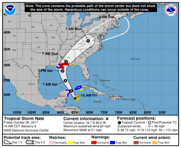
*A Hurricane Warning is now in effect from Grand Isle Louisiana to the Alabama/Florida border.
*A Storm Surge Warning is now in effect from Morgan City Louisiana to the Alabama/Florida border, and for the northern and western shores of Lake Pontchartrain.
*A Tropical Storm Warning is now in effect for metropolitan New Orleans, Lake Pontchartrain and Lake Maurepas, and from west of Grand Isle to Morgan City Louisiana.
*A Hurricane Watch is now in effect east of the Alabama/Florida border to the Okaloosa/Walton County Line.
*A Storm Surge Watch is now in effect east of the Alabama/Florida border to Indian Pass, Florida.
*A Tropical Storm Watch is now in effect east of the Okaloosa/Walton County Line to Indian Pass, Florida.
*Weather conditions will deteriorate along the Central Gulf Coast tomorrow with increasing wind and rain.
*The combination of a dangerous storm surge and the tide will cause normally dry areas near the coast to be flooded by rising waters moving inland from the shoreline. The water is expected to reach the following heights above ground if the peak surge occurs at the time of high tide…
Morgan City, Louisiana to the Alabama/FL border…4 to 7 ft
Alabama/FL border to Indian Pass, Florida…2 to 4 ft
The deepest water will occur along the immediate coast near and to the east of the landfall location, where the surge will be accompanied by large and destructive waves. Surge-related flooding depends on the relative timing of the surge and the tidal cycle, and can vary greatly over short distances.
*Weather conditions will begin to improve along the Gulf Coast Sunday afternoon as Nate moves northward.
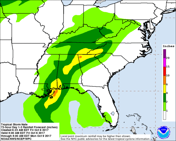
*For North/Central Alabama, most of the rain will come late Saturday night into Sunday. Rain amounts should average 2-4 inches, with isolated totals to 6 inches. Some flooding is possible.
*Gradient winds over North/Central Alabama will be in the 20-40 mph range Sunday. This could create some scattered tree damage, but widespread damage and power outages are not expected.
*Highest risk of tornadoes with Nate will come over the southern half of Alabama over the weekend.
*Morning models have shifted a bit to the east; so additional forecast track changes are possible.
*Wind and rain will diminish across North/Central Alabama late Sunday night. Showers remain possible Monday, however.
Look for a fresh blog discussion and new Weather Xtreme video by 4:00 this afternoon….
Category: ALL POSTS
About the Author (Author Profile)
James Spann is one of the most recognized and trusted television meteorologists in the industry. He holds the AMS CCM designation and television seals from the AMS and NWA. He is a past winner of the Broadcast Meteorologist of the Year from both professional organizations.Subscribe
If you enjoyed this article, subscribe to receive more just like it.


