Nate Rolls Into Alabama Over The Weekend
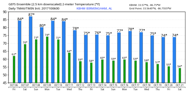
STILL DRY TODAY: One more dry day for Alabama; we expect a good supply of sunshine today with a high in the mid 80s this afternoon. But, all eyes in the weather office will be focused on Tropical Storm Nate, now in the western Caribbean with winds of 45 mph.
Here are the important points concerning Nate and our weekend weather…
*Nate is forecast to reach minimal hurricane strength by NHC just before landfall near the mouth of the Mississippi River late tomorrow night. From there, the circulation center moves through South Mississippi, and North/Central Alabama Sunday and Sunday night.
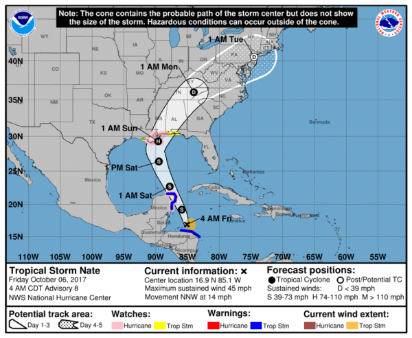
*The GFS and a number of tropical models suggest Nate will not reach hurricane strength, however, due to dry air, westerly shear, and cooler SSTs (sea surface temperatures) near the coast. One way or another, the impact will be pretty much the same for the Gulf Coast region.
A Storm Surge Watch is in effect for…
* Morgan City Louisiana to the Alabama/Florida border
* Northern and western shores of Lake Pontchartrain
A Hurricane Watch is in effect for…
* Morgan City Louisiana to the Mississippi/Alabama border
* Metropolitan New Orleans
* Lake Pontchartrain and Lake Maurepas
* Punta Herrero to Rio Lagartos Mexico
A Tropical Storm Watch is in effect for…
* Mississippi/Alabama border to the Okaloosa/Walton County Line
* West of Morgan City to Intracoastal City Louisiana
*Baldwin County officials have a voluntary evacuation recommendation for areas south of Alabama Highway 182 (Beach Boulevard) in Gulf Shores and Orange Beach, and the Fort Morgan peninsula beginning this morning. Also, a voluntary evacuation recommendation has been issued for the Causeway (U.S. 90) in Spanish Fort.
*Wind and rain will increase on the Gulf Coast late tonight and through the day tomorrow. A storm surge of 1-3′ is possible on the Alabama Gulf Coast and through the western part of the Florida Panhandle, and a few isolated tornadoes are possible well tomorrow. Rain will be heavy at times, but it won’t rain all day.
*Weather conditions will slowly improve on the coast by Sunday afternoon as Nate moves northward.
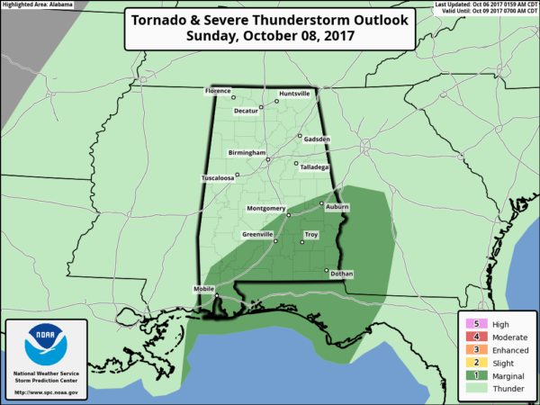
*Most of the rain for the northern half of Alabama will come Saturday night and Sunday; rain amounts should average 1-3″, with isolated heavier amounts of 4 to 5″ possible. Major flooding problems are not expected, however, since Nate will be moving along at a pretty good clip.
*Pressure gradient winds of 20-40 mph are possible over much of Alabama tomorrow night and Sunday. Probably not high enough for major tree and power line damage, but a few trees could come down.
*The main tornado threat Sunday will be south of a line from Mobile to Montgomery to Opelika. For now the tornado threat over North Alabama looks rather low.
*Winds will diminish Sunday night, but lingering showers are likely Monday.
FOOTBALL WEATHER: For the high school games tonight, the sky should be clear with temperatures falling from around 80 degrees at kickoff, through the 70s during the game.
Auburn hosts Ole Miss tomorrow at Jordan-Hare Stadium (11:00a CT kickoff)… the sky will be partly sunny with temperatures rising from near 78 degrees at kickoff into the low 80s by the final whistle. Only a small risk of a shower.
Alabama is on the road; they will take on the Texas A&M Aggies Saturday in College Station, Texas tomorrow evening (6:15p CT kickoff). The sky will be clear with temperatures falling from near 88 degrees at kickoff, to near 80 by the end of the game.
UAB’s homecoming is tomorrow; the Blazers take on Louisiana Tech at Legion Field (3:00p CT kickoff)… for now we are forecasting a partly sunny sky with 83 degrees at kickoff, falling to near 80 by the fourth quarter. The chance of a shower for now is small.
NEXT WEEK: Occasional showers Monday, only widely scattered showers Tuesday. Cooler, drier air arrives Wednesday through Friday with highs in the 70s and lows in the 50s.
BEACH FORECAST: Click here to see the AlabamaWx Beach Forecast Center page. The Beach Forecast is partially underwritten by the support of Brett/Robinson Vacation Rentals in Gulf Shores and Orange Beach. Click here to see Brett/Robinson’s Hot Deals now!
WEATHER BRAINS: Don’t forget you can listen to our weekly 90 minute netcast anytime on the web, or on iTunes. This is the show all about weather featuring many familiar voices, including our meteorologists here at ABC 33/40.
CONNECT: You can find me on all of the major social networks…
Facebook
Twitter
Google Plus
Instagram
Pinterest
Snapchat: spannwx
Look for the next Weather Xtreme video here by 4:00 this afternoon… enjoy the day!
Category: ALL POSTS, Weather Xtreme Videos
About the Author (Author Profile)
James Spann is one of the most recognized and trusted television meteorologists in the industry. He holds the AMS CCM designation and television seals from the AMS and NWA. He is a past winner of the Broadcast Meteorologist of the Year from both professional organizations.Subscribe
If you enjoyed this article, subscribe to receive more just like it.


