A Very Nice Midday Today, But Nate Looms In Our Future For The Weekend
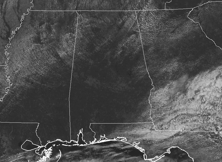
Another wonderful midday out there across Central Alabama for your Friday, but this nice weather is temporarily going to come to an end throughout the weekend as Tropical Storm Nate is expected to move through the area. Temperatures at 12:50 PM are currently running in the lower to mid-80s throughout the area. Birmingham is currently at 82 in Birmingham, while the warm spot is currently Montgomery at 88 degrees.
FOR THE REST OF YOUR FRIDAY
We’ll continue to have mostly to mainly clear skies throughout the remainder of the afternoon before clouds start to move in ahead of Tropical Storm Nate later tonight. Afternoon highs will be in the mid to upper 80s, with temperatures dropping off to the mid-70s to the lower 80s at the start of tonight’s high school football games. By the final whistle, we’ll have increasing clouds with temperatures dropping into the lower to mid-70s. Overnight lows will be in the mid-60s to the lower 70s.
This weekend’s weather will all be dependent on the track that Nate decides to take across Central Alabama. What we are thinking at this point is listed in the following paragraphs.
LATEST ON TROPICAL STORM NATE
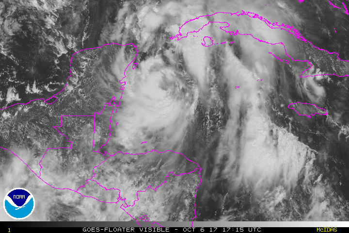
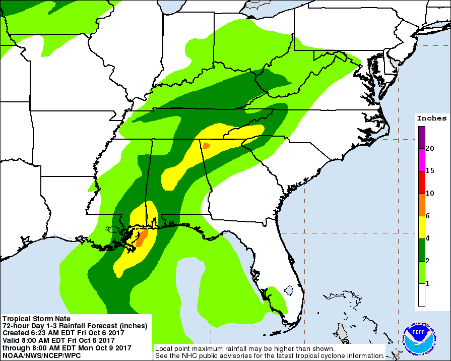
Nate is still a tropical storm at this point with maximum sustained winds of 50 MPH and is moving to the north-northwest at 21 MPH. Nate is currently approaching the Yucatan Peninsula and the extreme western parts of Cuba. The latest forecast track from the National Hurricane Center has shifted to the east a little over the last update. Landfall is forecast to occur very close to Alabama/Mississippi state line east of Pascagoula during the pre-dawn hours on Sunday as a strong tropical storm or a minimum category 1 hurricane.
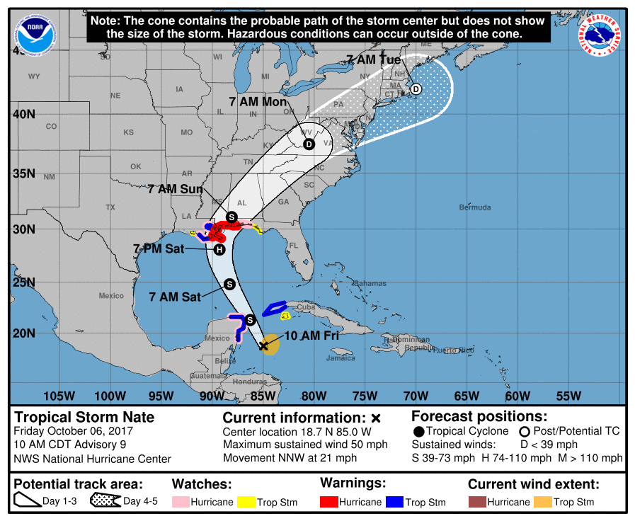
NHC TRACK – WHAT TO EXPECT AT THE BEACHES
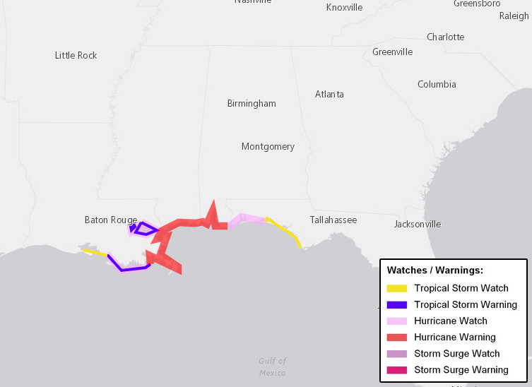
On this forecast track, conditions along the Alabama and western Florida Panhandle beaches will start to deteriorate beginning early Saturday morning and will gradually worsen throughout the day until the center of Nate passes by on Sunday morning. A Hurricane Warning is in effect from Grand Isle, Louisiana, eastward to the Alabama/Florida state line. A Storm Surge Warning is in effect from Morgan City, Louisiana to the Alabama/Florida border, and for the northern and western shores of Lake Pontchartrain.
Strong tropical storm force winds with hurricane force gusts can be expected late Saturday and into Sunday morning. Storm surge amounts of 4 to 7 feet above normal tide levels will be possible, with the deeper surge totals being closest to the shore due to rough surf. A few waterspouts or tornadoes will be possible to the east of the center of Nate until it passes to the north. Conditions will gradually start to improve throughout the day on Sunday as Nate moves farther north and away.
NHC TRACK – WHAT TO EXPECT FOR CENTRAL ALABAMA
On the current forecast track from the National Hurricane Center, the center of Nate should make it into the southwestern parts of Central Alabama by mid-morning on Sunday, even though the effects will start to be felt as early as Saturday morning. The center of Nate is forecast to move to the east-northeast throughout the southern half of Central Alabama and weakening as it moves along.
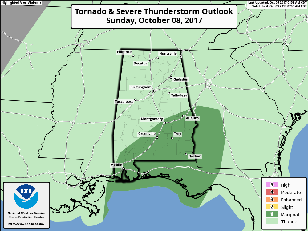
We can expect periods of tropical rainfall starting on Saturday afternoon and lasting through late Sunday night or into the pre-dawn hours on Monday. The strongest activity will occur mainly east of the I-65 corridor, especially north and northeast of the center. At this point, the northern half of the area will see some gusty winds of 20-30 MPH, while much of the southern half could see winds ranging from 30-55 MPH. The main tornado risk with Nate will mainly be in the southeastern corner of the area on Sunday, along and south of a line from Montgomery to Auburn. Rainfall amounts throughout the area can range from 2 to 4 inches, with higher localized totals possible. Conditions will be much better on Monday, even though scattered showers will still be likely.
THE TROPICS
Stay up-to-date with the latest updates on all of the tropical systems out in the Atlantic Ocean, Caribbean Sea, or in the Gulf of Mexico with the latest posts in our Tropical Weather section. Click here to see the latest.
GULF COAST WEATHER
With the approach of Nate, conditions will start to deteriorate along the Alabama and northwest Florida Gulf Coast on early Saturday morning. Rip currents and rough surf will start to affect the coastline on Friday afternoon. Tropical storm force winds, heavy rain and a few tornadoes will be possible this weekend, before much better conditions arrive for Monday. Be sure to keep up to date with the detailed forecasts from Fort Morgan over to Panama City Beach with the AlabamaWx Weather Blog.
Click here to see the AlabamaWx Beach Forecast Center page.
The Beach Forecast is partially underwritten by the support of Brett/Robinson Vacation Rentals in Gulf Shores and Orange Beach. Click here to see Brett/Robinson’s Off Season Deals now!
ON THIS DAY IN WEATHER HISTORY
1985 – A tropical wave, later to become Tropical Storm Isabel, struck Puerto Rico. As much as 24 inches of rain fell in 24 hours, and the severe flooding and numerous landslides resulting from the rain claimed about 180 lives.
WEATHERBRAINS
Check out the show at www.WeatherBrains.com. You can also subscribe on iTunes. You can watch the show live at live.bigbrainsmedia.com on Monday nights starting at 8:30 PM CDT. You will be able to see the show on the James Spann 24×7 weather channel on cable or directly over the air on the dot 2 feed.
Category: Alabama's Weather, ALL POSTS
About the Author (Author Profile)
Scott Martin is an operational meteorologist, professional graphic artist, musician, husband, and father. Not only is Scott a member of the National Weather Association, but he is also the Central Alabama Chapter of the NWA president. Scott is also the co-founder of Racecast Weather, which provides forecasts for many racing series across the USA. He also supplies forecasts for the BassMaster Elite Series events including the BassMaster Classic.Subscribe
If you enjoyed this article, subscribe to receive more just like it.


