Beautiful But Warm Out There At Midday
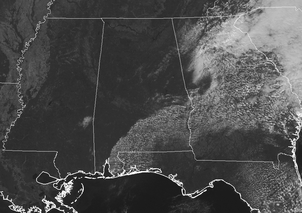
You can almost say completely clear skies across Central Alabama, but there are a few clouds drifting in from the east that are adding a few dabs of white on our cobalt blue canvas. Temperatures at 12:30 PM were ranging throughout the 80s in Central Alabama, with lower to mid-80s in the north and mid to upper 80s in the south. Warm spot was Troy at 88 degrees, while the cool spots were Haleyville and Cullman at 81 degrees. Birmingham was at 84 degrees.
What To Expect For The Rest Of Your Friday
With the flow of air coming out of the east today, we’ll have some moisture starting to creep back into the eastern parts of Central Alabama. We could see an isolated shower or two east of a line from Selma to Clanton to Anniston, but the odds of that happening are only at 1-in-5. Just about everyone will remain dry under mostly sunny skies. Afternoon highs will be in the mid to upper 80s for much of the area, with lower 80s in the northwest near the Hamilton and Haleyville areas.
Any rain chances will dissipate as we lose the sunlight and daytime heating. For the high school football games, weather will be rather nice underneath mostly clear skies. Temperatures will be in the mid-70s to the lower 80s throughout the area just before kickoff, and falling into the upper 60s to the mid 70s by the final whistle. Overnight lows will range throughout the 60s.
The Central Alabama Weekend
We will continue to stay warm before a cold front moves into Central Alabama late on Sunday, bringing with it a chance of rain and cooler temperatures. The upper ridge will continue its hold on our pattern for Saturday with mostly clear to partly cloudy skies. Ridging breaks down as the cold front gets closer and starts to invade the area on Sunday. We’ll have a chance of showers late on Sunday into Sunday night out ahead of the front, but amounts will be around or less than 1/4 inch. Highs will be in the lower to mid-80s for most on both day, with upper 80s in the south.
Race Weekend At Talladega
The weather will be dry at the superspeedway through Saturday evening, with warm afternoons and pleasant nights. Highs today and tomorrow will be in the low to mid-80s. For Sunday, the sky will be partly cloudy, and we will mention a small risk of a brief shower late in the afternoon. The high will be in the mid-80s.
College Football Weather
Alabama will host the Arkansas Razorbacks Saturday evening (6:15p CT kickoff) at Bryant-Denny Stadium in Tuscaloosa for homecoming. Skies will be mostly fair. About 82 degrees at kickoff, falling to near 75 degrees by the final whistle.
Auburn travels to Baton Rouge to take on LSU Saturday afternoon (2:30p CT kickoff). Sunny skies, with the temperature close to 88 degrees at kickoff, falling back into the low 80s by the fourth quarter.
UAB will host Middle Tennessee at Legion Field in Birmingham Saturday evening (5:30p CT kickoff). Clear skies with temperatures falling from near 83 at kickoff, into the 70s by the second half.
Next Week
We’ll have nearly perfect fall weather throughout Central Alabama for the work week ahead… We may have a few left over showers on Monday in the southeastern parts of the area from the passage of the cold front, but dry conditions can be expected throughout the end of the forecast period on Thursday, with afternoon highs in the 70s each day.
The Tropics Are Quiet Close To Home
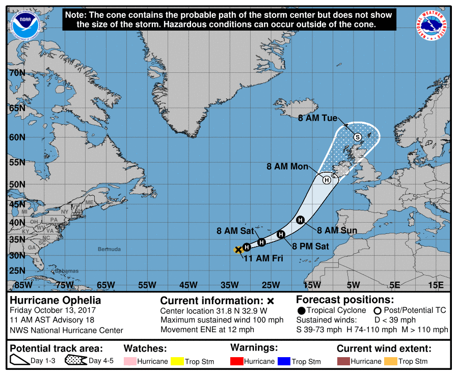
Ophelia is racing away towards the east-northeast and will turn to the northeast affecting Ireland on Monday as a post-tropical hurricane, then Scotland and northern England on Tuesday. The last time a hurricane struck the shores of Ireland was Debbie on September 16th back in 1961. The highest wind gust from Debbie of 107 MPH was recorded at Shannon Airport
Stay up-to-date with the latest updates on all of the tropical systems out in the Atlantic Ocean, Caribbean Sea, or in the Gulf of Mexico with the latest posts in our Tropical Weather category. Click here to see the latest.
Gulf Coast Weather
Be sure to keep up to date with the detailed forecasts from Fort Morgan over to Panama City Beach with the AlabamaWx Weather Blog. Click here to see the AlabamaWx Beach Forecast Center page.
The Beach Forecast is partially underwritten by the support of Brett/Robinson Vacation Rentals in Gulf Shores and Orange Beach. Click here to see Brett/Robinson’s Off Season Deals now!
On This Day In Weather History
1846 – A great hurricane tracked across Cuba, Florida, Georgia, the Carolinas, Virginia and Pennsylvania. The hurricane inflicted major damage along its entire path, which was similar to the path of Hurricane Hazel 108 years later. The hurricane caused great damage at Key West FL, and at Philadelphia PA it was the most destructive storm in thirty years.
WeatherBrains
Check out the show at www.WeatherBrains.com. You can also subscribe on iTunes. You can watch the show live at live.bigbrainsmedia.com on Monday nights starting at 8:30 PM CDT. You will be able to see the show on the James Spann 24×7 weather channel on cable or directly over the air on the dot 2 feed.
Category: Alabama's Weather, ALL POSTS
About the Author (Author Profile)
Scott Martin is an operational meteorologist, professional graphic artist, musician, husband, and father. Not only is Scott a member of the National Weather Association, but he is also the Central Alabama Chapter of the NWA president. Scott is also the co-founder of Racecast Weather, which provides forecasts for many racing series across the USA. He also supplies forecasts for the BassMaster Elite Series events including the BassMaster Classic.Subscribe
If you enjoyed this article, subscribe to receive more just like it.


