Much Cooler Air Arrives Monday
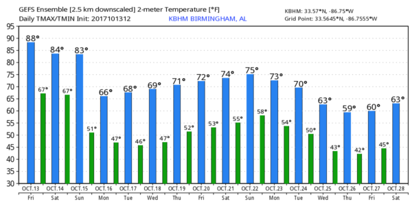
SUMMER-LIKE AFTERNOON: Temperatures have climbed around 30 degrees from the lows we enjoyed this morning; most places are in the mid to upper 80s this afternoon. So far, Birmingham’s high is 88 degrees, within three degrees of the record high for October 13 of 91, set in 1963. The air is dry, and the sky is sunny. Tonight will be clear and not as cool as last night with lows mostly in the 60s early tomorrow.
THE WEEKEND: Tomorrow will be partly sunny, warm, and a little more humid with temperatures again climbing well into the 80s. Then, on Sunday, we expect a mix of sun and clouds with only a small risk of an afternoon shower. The high Sunday will be in the mid 80s again.
But, a cold front will push in here Sunday night with a chance of showers, and maybe even a thunderstorm in spots. Rain won’t be especially heavy, and the best chance of showers will come from 6:00 p.m. Sunday through 4:00 a.m. Monday. For most places rain amounts will be 1/4″ or less.
RACE WEEKEND AT TALLADEGA: Warm, dry weather today and tomorrow with highs in the 80s. For the Alabama 500 Sunday, we project afternoon temperatures in the low to mid 80s with only a slight risk of shower; a few showers are more likely Sunday night ahead of a cold front.
FOOTBALL WEATHER: A clear sky for the high school football games tonight; temperatures will fall from near 80 at kickoff through the 70s during the games.
Alabama will host the Arkansas Razorbacks tomorrow evening (6:15p CT kickoff) at Bryant-Denny Stadium in Tuscaloosa for homecoming… the sky will be mostly fair. About 82 degrees at kickoff, falling to near 75 by the final whistle.
Auburn travels to Baton Rouge to take on LSU tomorrow afternoon (2:30p CT kickoff)… the game will be played under a sunny sky; the temperature will be close to 88 degrees at kickoff, falling back into the low 80s by the fourth quarter.
UAB will host Middle Tennessee at Legion Field in Birmingham tomorrow evening (5:30p CT kickoff)… expect a clear sky with temperatures falling from near 83 at kickoff, into the 70s by the second half.
NEXT WEEK: The sky becomes partly to mostly sunny Monday, and the day will be breezy and much cooler with a high in the upper 60s. The rest the week looks great with sunny pleasant days and clear chilly nights. Looks like we drop into the 40s Tuesday and Wednesday mornings; highs will be in the 70s. No sign of any 80s after Sunday for a while.
TROPICS: A disturbance east of the Leeward Islands has only a low chance of developing in coming days; if anything forms there it will move north and seems to be no threat to land. Hurricane Ophelia is still in the eastern Atlantic; it will threaten Ireland and the U.K. early next week as a post-tropical cyclone. The rest of the Atlantic basin is quiet.
BEACH FORECAST: Click here to see the AlabamaWx Beach Forecast Center page. The Beach Forecast is partially underwritten by the support of Brett/Robinson Vacation Rentals in Gulf Shores and Orange Beach. Click here to see Brett/Robinson’s Hot Deals now!
WEATHER BRAINS: Don’t forget you can listen to our weekly 90 minute netcast anytime on the web, or on iTunes. This is the show all about weather featuring many familiar voices, including our meteorologists here at ABC 33/40.
CONNECT: You can find me on all of the major social networks…
Facebook
Twitter
Google Plus
Instagram
Pinterest
Snapchat: spannwx
Look for my next Weather Xtreme video here Monday morning by 7:00… Brian Peters will have the video updates tomorrow and Sunday. Enjoy the weekend!
Category: Alabama's Weather, ALL POSTS, Weather Xtreme Videos
About the Author (Author Profile)
James Spann is one of the most recognized and trusted television meteorologists in the industry. He holds the AMS CCM designation and television seals from the AMS and NWA. He is a past winner of the Broadcast Meteorologist of the Year from both professional organizations.Subscribe
If you enjoyed this article, subscribe to receive more just like it.


