Cold Front Moves Through Tomorrow Night
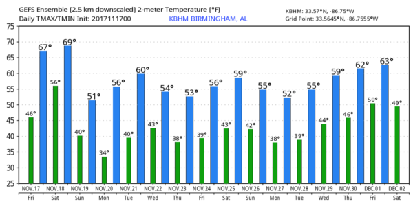
COLD START: Temperatures are at or below freezing in a few spots over North Alabama early this morning, with most places in the 35-40 degree range. We warm nicely today with ample sunshine along with a high in the upper 60s. Clouds move in tonight ahead of the approaching cold front.
THE WEEKEND: Showers and thunderstorms will move into Northwest Alabama tomorrow afternoon; SPC now has a “marginal risk” of severe storms defined for the Tennessee Valley…
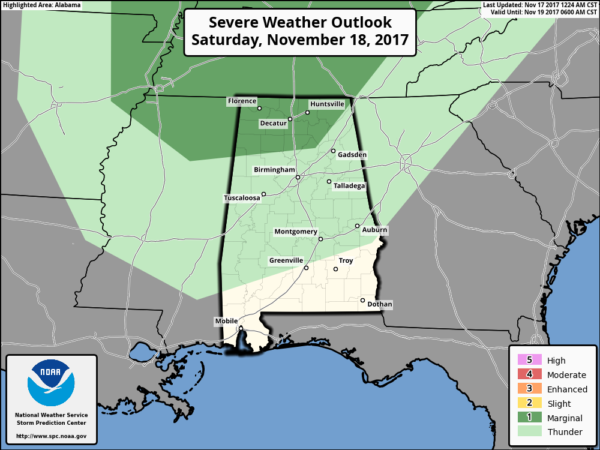
Some of the storms could produce gusty winds and small hail over far North Alabama, but they will weaken as they move to the south tomorrow evening.
The main window for showers and storms will come from about 2:00 until 11:00 p.m. tomorrow. Rain amounts should be generally 1/2 inch or less.
Then, Sunday will be mostly sunny, breezy, and much cooler with a high in the 52-56 degree range. Sunday night will be the coldest night so far this season; a widespread freeze is likely early Monday with lows in the 26-32 degree range.
FOOTBALL WEATHER: For high school playoff games tonight, the weather looks pleasant and dry with temperatures falling from the low 60s at kickoff, into the upper 50s by the final whistle.
Tomorrow, Alabama hosts the Mercer Bears at Bryant-Denny Stadium (11a CT kickoff)… the sky will be mostly cloudy, a shower is possible by the fourth quarter… but the best chance of showers in Tuscaloosa should come after 3:00 p.m. Temperatures will be in the mid 60s at kickoff, rising to near 70 by the second half.
Auburn will host Louisiana-Monroe Saturday at Jordan-Hare Stadium (11a CT kickoff)… Mostly cloudy but dry; best chance of rain in Auburn comes after 6:00 p.m. Temperatures will be in the 65-70 degree range.
UAB will be down in Gainesville to take on the Florida Gators (3p CT kickoff)… the sky will be mostly sunny with a kickoff temperature near 80 degrees at kickoff… dropping back into the mid 70s by the second half.
THANKSGIVING WEEK: For now, the week looks dry with cool days and chilly nights. Highs in the low to mid 60s Tuesday and Wednesday, dropping into the 50s Thursday and Friday. Lows in the 30s and 40s. And, at this point Iron Bowl Saturday also looks cool and dry, although some clouds are possible over East Alabama. See the Weather Xtreme video for maps, graphics, and more details.
TROPICS: A disturbance in the far Southwest Caribbean has a low chance of developing over the next 5 days… otherwise the Atlantic basin is quiet.
BEACH FORECAST: Click here to see the AlabamaWx Beach Forecast Center page. The Beach Forecast is partially underwritten by the support of Brett/Robinson Vacation Rentals in Gulf Shores and Orange Beach. Click here to see Brett/Robinson’s Hot Deals now!
WEATHER BRAINS: Don’t forget you can listen to our weekly 90 minute netcast anytime on the web, or on iTunes. This is the show all about weather featuring many familiar voices, including our meteorologists here at ABC 33/40.
CONNECT: You can find me on all of the major social networks…
Facebook
Twitter
Google Plus
Instagram
Pinterest
Snapchat: spannwx
Look for the next Weather Xtreme video here by 4:00 this afternoon… enjoy the day!
Category: Alabama's Weather, ALL POSTS, Weather Xtreme Videos
About the Author (Author Profile)
James Spann is one of the most recognized and trusted television meteorologists in the industry. He holds the AMS CCM designation and television seals from the AMS and NWA. He is a past winner of the Broadcast Meteorologist of the Year from both professional organizations.Subscribe
If you enjoyed this article, subscribe to receive more just like it.


