Cold Tonight; Some Rain By The Weekend
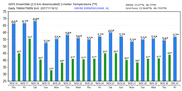
SCATTERED FROST EARLY TOMORROW: With a clear sky and a light wind, temperatures will drop into the mid to upper 30s early tomorrow across much of North/Central Alabama with potential for scattered light frost. Then, during the day tomorrow, we warm nicely as temperatures rise into the 67-70 degree range with a good supply of sunshine.
THE WEEKEND: Clouds move into the state Saturday ahead of a cold front, and a band of showers, and possibly a thunderstorm, will move into the state by mid to late afternoon. SPC has defined a “marginal risk” of severe storms for the far northwest corner of Alabama…
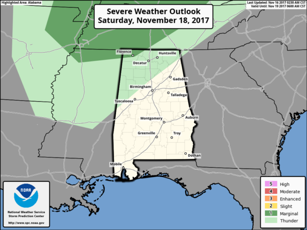
Storms will weaken as they move into a more stable airmass over our state, and we don’t expect much thunder south of the Tennessee River. The main window for showers will come from 3:00 p.m. Saturday through 3:00 a.m. Sunday, and rain amounts should be 1/2″ or less. Saturday’s high will be close to 70 degrees.
The sky becomes mostly sunny Sunday, but the day will be breezy and sharply cooler with a high between 50 and 55 degrees. Sunday night will be cold; lows by early Monday will be in the 26-32 degree range. Our first real widespread freeze of the season.
FOOTBALL WEATHER: For high school playoff games tomorrow night, the weather looks pleasant and dry with temperatures falling from the mid 60s at kickoff, into the upper 50s by the final whistle.
Saturday, Alabama hosts the Mercer Bears at Bryant-Denny Stadium (11a CT kickoff)… the sky will be mostly cloudy, and we will mention just a small chance of a shower during the second half of the game. Best chance of showers in Tuscaloosa should come after 4:00 p.m. Temperatures will be in the 60s.
Auburn will host Louisiana-Monroe Saturday at Jordan-Hare Stadium (11a CT kickoff)… Mostly cloudy but dry; best chance of rain in Auburn comes after 6:00 p.m. Temperatures will also be in the 60s.
UAB will be down in Gainesville to take on the Florida Gators (3p CT kickoff)… the sky will be mostly sunny with a kickoff temperature near 80 degrees at kickoff… dropping back into the mid 70s by the second half.
NEXT WEEK: Monday and Tuesday will be cool and dry. Beyond that, forecast confidence is low as model continue to show a wide range of possibilities. We will keep the forecast dry Wednesday with a high in the 50s. Cool, dry weather is also likely Thanksgiving Day and Black Friday, but the European global model develops a system in the Gulf of Mexico with potential to bring clouds and a few showers up this way. We might have to insert the chance of some rain if this trend continues. See the Weather Xtreme video for maps, graphics, and more details.
TROPICS: A disturbance on an old surface front over the far Southwest Caribbean has only a low chance of development over the next five days. The rest of the Atlantic basin is very quiet.
BEACH FORECAST: Click here to see the AlabamaWx Beach Forecast Center page. The Beach Forecast is partially underwritten by the support of Brett/Robinson Vacation Rentals in Gulf Shores and Orange Beach. Click here to see Brett/Robinson’s Hot Deals now!
WEATHER BRAINS: Don’t forget you can listen to our weekly 90 minute netcast anytime on the web, or on iTunes. This is the show all about weather featuring many familiar voices, including our meteorologists here at ABC 33/40.
CONNECT: You can find me on all of the major social networks…
Facebook
Twitter
Google Plus
Instagram
Pinterest
Snapchat: spannwx
I had a great time today visiting with the 3rd graders at Attalla Elementary… be looking for them on the Pepsi KIDCAM today at 5:00 on ABC 33/40 News! The next Weather Xtreme video will be posted here by 7:00 a.m. tomorrow…
Category: Alabama's Weather, ALL POSTS, Weather Xtreme Videos
About the Author (Author Profile)
James Spann is one of the most recognized and trusted television meteorologists in the industry. He holds the AMS CCM designation and television seals from the AMS and NWA. He is a past winner of the Broadcast Meteorologist of the Year from both professional organizations.Subscribe
If you enjoyed this article, subscribe to receive more just like it.


