Cold Air Invades Alabama Tomorrow
MORE FOG: A dense fog advisory is in effect for parts of Central and South Alabama early this morning; the foggy mornings have been the result of a persistent pattern with a clear sky, light wind, wet ground, and temperatures falling to the dewpoints during the early morning hours. Once the fog dissipates we project a of mix of sun and clouds today with a high in the 60s.
Clouds thicken tonight, and a few showers are possible after midnight over North Alabama ahead of the Arctic front.
WET, COLDER TOMORROW: Rain will push into Alabama tomorrow as the front moves southeast. The good news is that we don’t expect any severe storms, although some thunder is possible. Looks like a decent part of the rain will be post-frontal, in the colder air. Rain amounts of around 1/2 inch are likely.
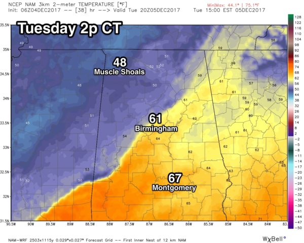
And, it is important to note that temperatures will be going the wrong way tomorrow. For the northwest corner of the state, the high will be reached during the pre-dawn hours… for places like Birmingham, Tuscaloosa, Anniston, and Gadsden, we peak around 60 degrees a midday, then temperatures fall into the 40s during the afternoon with a cold rain falling.
WEDNESDAY THROUGH FRIDAY: The weather looks generally cloudy and cold for the northern half of the state… and to the south periods of rain are likely Wednesday and Thursday over South Alabama. Highs will be generally in the 40s for area along I-20 and to the north, with 50s for the southern counties of the state. For now Friday looks mostly dry statewide with chilly temperatures continuing.
SNOW FLAKES? A clipper type system, moving down the back side of a deep upper trough over the eastern third of the nation, has potential to squeeze out a few snow flurries or convective snow showers over roughly the northern third of Alabama Friday night and Saturday.
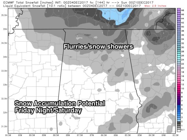
Traditionally there isn’t much moisture with clippers, and for now accumulating snow doesn’t look especially likely. But, with heavier snow showers, especially up north over the Tennessee Valley, the ground could be white in spots in grassy areas and north facing locations. Needless to say, we will keep a close eye on the situation as we get closer to the weekend.
COLD WEEKEND: The cold air is the big story for the weekend; we won’t get out of the 30s Saturday with clouds hanging around much of the day, and by daybreak Sunday we will see a low in the 18-22 degree range as the sky clears and the wind becomes light. Sunday will be mostly sunny with a high between 45 and 49 degrees.
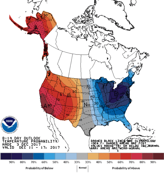
NEXT WEEK: The pattern favors below average temperatures through mid-December; for now the first part of next week looks dry and cold. See the Weather Xtreme video for maps, graphics, and more details.
BEACH FORECAST: Click here to see the AlabamaWx Beach Forecast Center page. The Beach Forecast is partially underwritten by the support of Brett/Robinson Vacation Rentals in Gulf Shores and Orange Beach. Click here to see Brett/Robinson’s Hot Deals now!
WEATHER BRAINS: Don’t forget you can listen to our weekly 90 minute netcast anytime on the web, or on iTunes. This is the show all about weather featuring many familiar voices, including our meteorologists here at ABC 33/40.
CONNECT: You can find me on all of the major social networks…
Facebook
Twitter
Google Plus
Instagram
Pinterest
Snapchat: spannwx
I have a weather program this morning at Englewood Elementary in Tuscaloosa… look for the next Weather Xtreme video here by 4:00 this afternoon. Enjoy the day!
Category: Alabama's Weather, ALL POSTS, Weather Xtreme Videos
About the Author (Author Profile)
James Spann is one of the most recognized and trusted television meteorologists in the industry. He holds the AMS CCM designation and television seals from the AMS and NWA. He is a past winner of the Broadcast Meteorologist of the Year from both professional organizations.Subscribe
If you enjoyed this article, subscribe to receive more just like it.


