Cold Air Settles In Tonight; A Few Snow Flakes Friday Morning?
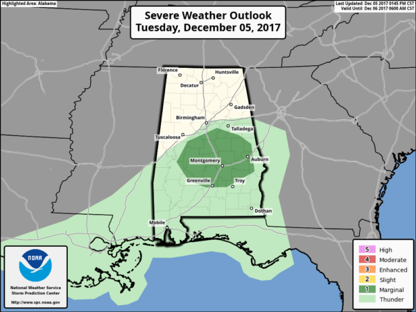
ACTIVE DAY: A strong cold front continues to pass through Alabama this afternoon bringing widespread rain and a few thunderstorms. Heavier storms are over the central counties ahead of the front, where SPC maintains a “marginal risk” of severe weather through the evening…
Temperatures have dropped into the 40s over Northwest Alabama, and the cold air will overspread all of North and Central Alabama in coming hours behind the front. Rain will taper off tonight as the front continues moving southward.
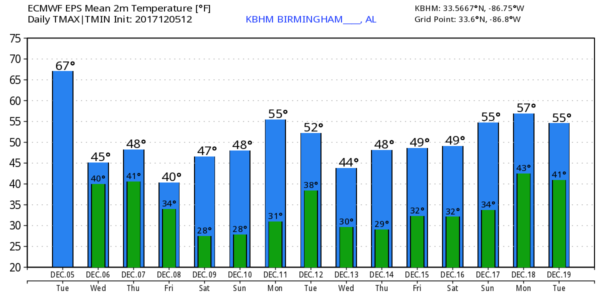
TOMORROW/THURSDAY: An “overrunning” pattern will set up across Alabama tomorrow; this is when warm, moist air overrides a cold airmass near the surface. This means a cold, wet day with temperatures hovering around 40 degrees all day with light rain or drizzle at times. Thursday will be mostly cloudy, but not as wet with just some scattered light rain mostly over the southern counties of the state. The high Thursday should be in the upper 40s for most places.
A FEW FRIDAY FLAKES? The next wave along the front to the south will bring more precipitation up into Central Alabama Friday morning, and the lower atmosphere could be cold enough for a few snow flakes. The reliable European global model agrees with this idea, although the GFS model keeps the precipitation father south and shows just some rain for Southeast Alabama.
We will mention a chance of some light snow, or light snow mixed with rain, Friday morning for areas south of I-20, and generally north of U.S. 80.
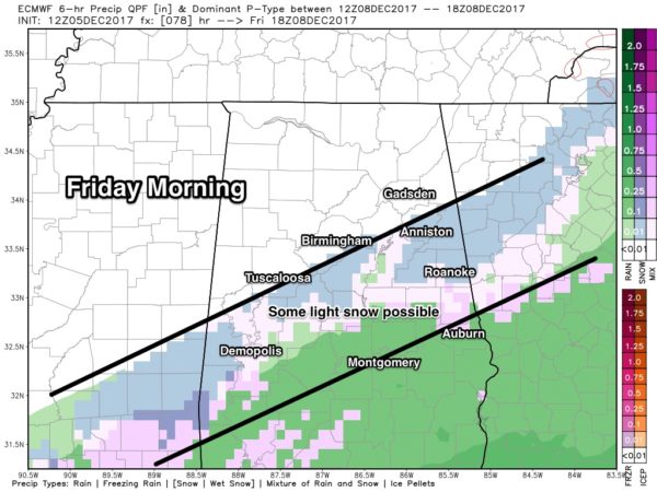
Temperatures should be above freezing, and accumulation is unlikely, and for now we expect no significant impact. We will keep a close eye on model runs and adjust the forecast as needed in coming days.
Otherwise, Friday will be cold with a high only in the low 40s for much of North/Central Alabama. The northern third of the state will be dry.
THE ALABAMA WEEKEND: Global models have trended drier with the clipper Saturday, and for now it looks like the best chance of snow flurries or snow showers will be across Tennessee and Kentucky, although a few light flurries could dip southward into the Tennessee Valley of far North Alabama. Otherwise, Saturday and Sunday are looking cold and dry with highs generally in the 40s and lows well below freezing. Coldest morning should come early Sunday, with lows well down in the 20s, with teens for colder places.
NEXT WEEK AND BEYOND: A blocked upper air pattern suggests temperatures around here will remain below average for at least the next 15 days… and for now much of next week looks dry. See the Weather Xtreme video for maps, graphics, and more details.
BEACH FORECAST: Click here to see the AlabamaWx Beach Forecast Center page. The Beach Forecast is partially underwritten by the support of Brett/Robinson Vacation Rentals in Gulf Shores and Orange Beach. Click here to see Brett/Robinson’s Hot Deals now!
WEATHER BRAINS: Don’t forget you can listen to our weekly 90 minute netcast anytime on the web, or on iTunes. This is the show all about weather featuring many familiar voices, including our meteorologists here at ABC 33/40.
CONNECT: You can find me on all of the major social networks…
Facebook
Twitter
Google Plus
Instagram
Pinterest
Snapchat: spannwx
I had a great time today with the 5th graders at Southside Elementary in Etowah County… be looking for them on the Pepsi KIDCAM today at 5:00 on ABC 33/40 News! The next Weather Xtreme video will be posted here by 7:00 a.m. tomorrow…
Category: Alabama's Weather, ALL POSTS, Weather Xtreme Videos
About the Author (Author Profile)
James Spann is one of the most recognized and trusted television meteorologists in the industry. He holds the AMS CCM designation and television seals from the AMS and NWA. He is a past winner of the Broadcast Meteorologist of the Year from both professional organizations.Subscribe
If you enjoyed this article, subscribe to receive more just like it.


