Conditions Continue To Deteriorate For Central Alabama
UPDATE AT 10:50 AM
The Randolph County Emergency Management Agency are requesting that residents remain off the roadways through this evening. All county roads and bridges have become impassible. Many accidents have already occurred.
Roads are starting to be closed in Alabaster due to powerlines being down (Alabaster PD).
Wintry mixed precipitation has accumulated and made the roadways extremely hazardous. All roads should be left open to emergency responders only, unless you are seeking medical treatment, going to work, or undertaking a similar necessary type of travel.
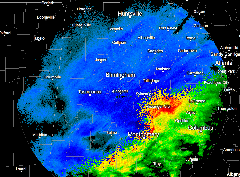
RADAR CHECK AT 10:00 AM
The latest radar image across North/Central Alabama continues to show mostly snow falling across the areas, with a rain/snow mix or sleet falling down in the southeastern parts of the area around the Eclectic to Alexander City to Roanoke areas. There is still plenty of snow back to our southwest in southern Mississippi and into eastern Louisiana, so we still have a few more hours of snowfall left across the area. Accumulation reports of up to 5 inches have already come in and I wouldn’t be surprised if a few higher amounts will be reported by the time this event is over.
ROAD CLOSURES / POWER OUTAGES / DELAYS
• All streets are reported closed in Anniston (Anniston PD). Many traffic accidents were being reported earlier throughout Calhoun County).
• All streets are reported closed in Oxford (Oxford PD).
• All streets are reported closed in Lincoln (Lincoln City Officials).
• Power is out for most of the city of Helena. Traffic lights are out throughout the city, and phones are down at the Helena Police Department. Call 911 for emergencies.
• Many power outages being reported in Pelham (Pelham PD). Lines are down due to the heavy wet snow.
• All Piedmont city roads are closed (Piedmont PD).
• Delays and cancellations are starting to occur at the Birmingham International Airport.
Please be careful if you are out and about today with road conditions deteriorating out there. May be a good idea to get to a place where you need to be and settle for the rest of the day. Temperatures are not expected to go that far above freezing today, as highs should top out in the mid to upper 30s. Those temperatures will quickly start dropping below freezing by 6:00 PM in the north and will be at or below freezing for everyone by midnight. Black ice will become an issue across the area by nightfall.
Category: Alabama's Weather, ALL POSTS
About the Author (Author Profile)
Scott Martin is an operational meteorologist, professional graphic artist, musician, husband, and father. Not only is Scott a member of the National Weather Association, but he is also the Central Alabama Chapter of the NWA president. Scott is also the co-founder of Racecast Weather, which provides forecasts for many racing series across the USA. He also supplies forecasts for the BassMaster Elite Series events including the BassMaster Classic.Subscribe
If you enjoyed this article, subscribe to receive more just like it.


