An Update To Our Weather Situation At 2:45PM
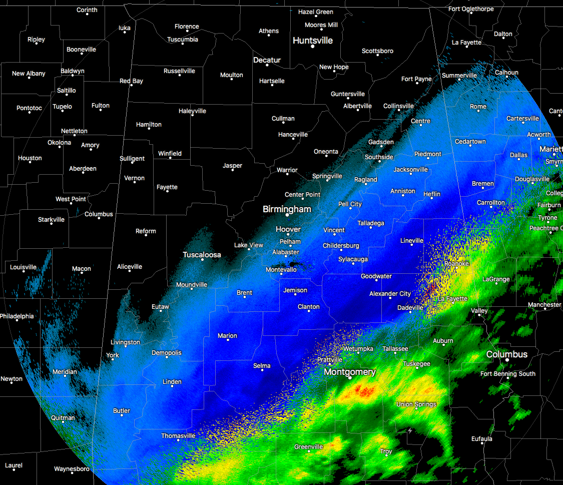
RADAR CHECK AT 2:25 PM
The snow band has now moved east of the I-20/59 and I-59 corridor at this point, with moderate to heavy snow showers now affecting about a 50-mile-wide swath south of a line from York to Hoover to Centre, with a mix of sleet and rain falling just south of the snow band. At my house, we ended up with an impressive 2.5 inches of snow, but I know there are plenty of locations that have received well more than that. A few places have reported to the NWS Birmingham Office totals of 6 inches, but I wouldn’t be surprised that we could have higher totals than that once the snow finally moves out of Central Alabama later tonight and into the overnight hours.
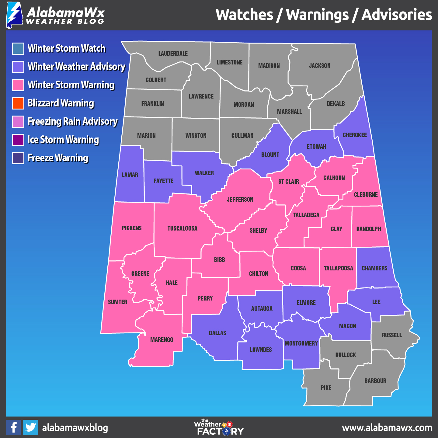
A Winter Storm Warning continues in effect until midnight tonight for Bibb, Calhoun, Chilton, Clay, Cleburne, Coosa, Greene, Hale, Jefferson, Marengo, Perry, Randolph, Shelby, St. Clair, Sumter, Talladega, Tallapoosa, and Tuscaloosa counties until 12:00 AM Saturday.
A Winter Weather Advisory continues in effect for Autauga, Blount, Chambers, Cherokee, Dallas, Elmore, Etowah, Fayette, Lamar, Pickens, and Walker counties until 12:00 AM Saturday.
THOUGHTS FOR TONIGHT AND TOMORROW
Icing conditions will become a problem as we lose the daylight and move into the early evening hours. The major highways and interstates may be ok to travel on, but the worry spots will be those secondary and smaller side roads. The best idea for travel is DON’T. If you do not have to get out tonight, please stay off the roads. Only get out if you have to go to work or you have an emergency. Keep the roads open to the emergency response vehicles and utilities as they restore power to those who have lost it during the snow storm.
Models are trending that the temperatures will fall slowly from the daytime highs throughout the evening hours before much of Alabama drops below freezing after 10-11PM tonight. That will actually help out with evaporating some of the moisture off of the roadways where the snow has come to an end. Once the skies clear out and the temperature starts dropping quicker, we could see overnight lows bottom as low as the upper teens to the upper 20s.
It will be a slow progression to the east with the snow and rain/snow mix through the rest of the evening, with the final few flakes leaving Central Alabama by the time the sun rises on Saturday morning. Temperatures throughout the morning will be on the slow rise and not making it above freezing until 9-10AM. So before you head out somewhere in the morning, check with ABC 33/40 to see if there are any road closures. No sense in having an accident by trying to get somewhere before roads are in good shape.
Saturday’s weather will be brilliant but chilly, as skies will be sunny and highs making it up into the lower to mid-40s. You may have some snow melt off, but it make take a day or two before we say goodbye to the last traces of this snow event. Lows will once again drop into the 20s throughout Central Alabama under clear skies for the overnight hours on Saturday night.
Category: Alabama's Weather, ALL POSTS
About the Author (Author Profile)
Scott Martin is an operational meteorologist, professional graphic artist, musician, husband, and father. Not only is Scott a member of the National Weather Association, but he is also the Central Alabama Chapter of the NWA president. Scott is also the co-founder of Racecast Weather, which provides forecasts for many racing series across the USA. He also supplies forecasts for the BassMaster Elite Series events including the BassMaster Classic.Subscribe
If you enjoyed this article, subscribe to receive more just like it.


