Wet, Stormy Today… Much Colder By Christmas
SOAKING RAINS: A flash flood watch remains in effect for the Tennessee Valley of North Alabama this morning; radar shows widespread, soaking rain in most areas north of I-20. The rain will slowly expand southward today, and with some surface based instability involved, we could see a few strong thunderstorms later this morning. SPC maintains a “marginal risk” of severe storms for much of Central Alabama…
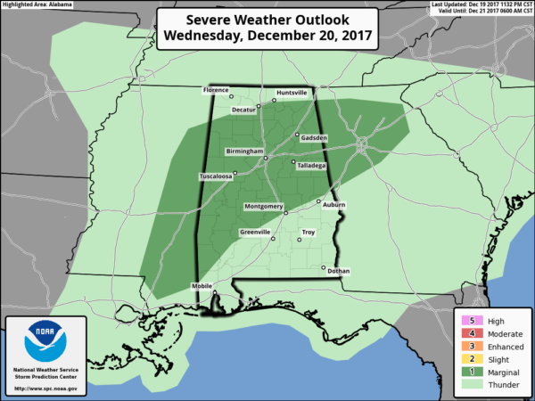
The overall threat looks fairly low, but a few storms could produce strong gusty winds. The tornado threat is also very low, but but zero. Rain will taper off this afternoon as the upper trough shifts eastward. Today will be very mild for December with a high in the low 70s.
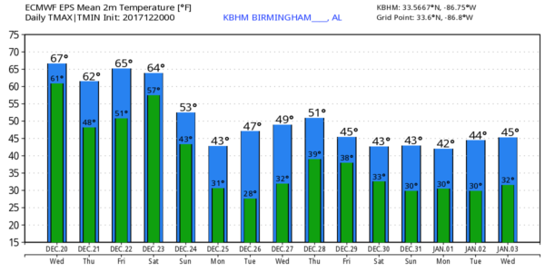
TOMORROW/FRIDAY: Tomorrow will be dry and mild; with a mix of sun and clouds we project a high in the 65-70 degree range. And, it now looks like a decent part of the day Friday will be dry with a high not far from 70 degrees, but the sky will be mostly cloudy, and rain will likely return Friday night ahead of a sharp cold front. Some thunder is possible Friday night, but for now severe storms are not expected.
THE ALABAMA WEEKEND: Saturday will be a wet, cooler day with periods of rain. Temperatures will hold in the 50s most of the day, and some North Alabama communities could drop into the 40s by mid to late afternoon as cold air advection begins. Then, on Sunday, the sky becomes partly sunny with a high in the 40s along with a cool north breeze.
FOOTBALL WEATHER: The annual Birmingham Bowl is Saturday; Texas Tech vs South Florida… the game kicks off at 11:00 a.m. at Legion Field. The sky will be cloudy with rain likely during the game; temperatures will be in the 50s. Not exactly “Chamber of Commerce” weather, but on the positive side there is no severe weather risk, and I doubt if any thunderstorms will be involved.
CHRISTMAS DAY: Monday will be cold and dry with a good supply of sunshine; we start the day in the 20s, and the high will be between 40 and 45 degrees.
REST OF NEXT WEEK: Dry weather continues Tuesday through Thursday with sunny cool days and fair cold nights; highs mostly in the 40s, and lows in the 25-32 degree range. Clouds return late in the week, and a storm system will bring rain back to the state at some point the following weekend (December 30-31)… see the Weather Xtreme video for maps, graphics, and more details.
BEACH FORECAST: Click here to see the AlabamaWx Beach Forecast Center page. The Beach Forecast is partially underwritten by the support of Brett/Robinson Vacation Rentals in Gulf Shores and Orange Beach. Click here to see Brett/Robinson’s Hot Deals now!
WEATHER BRAINS: Don’t forget you can listen to our weekly 90 minute netcast anytime on the web, or on iTunes. This is the show all about weather featuring many familiar voices, including our meteorologists here at ABC 33/40.
CONNECT: You can find me on all of the major social networks…
Facebook
Twitter
Google Plus
Instagram
Pinterest
Snapchat: spannwx
Look for the next Weather Xtreme video here by 4:00 this afternoon… enjoy the day!
Category: Alabama's Weather, ALL POSTS, Weather Xtreme Videos
About the Author (Author Profile)
James Spann is one of the most recognized and trusted television meteorologists in the industry. He holds the AMS CCM designation and television seals from the AMS and NWA. He is a past winner of the Broadcast Meteorologist of the Year from both professional organizations.Subscribe
If you enjoyed this article, subscribe to receive more just like it.


