Stronger Storms Now Affecting Etowah & St. Clair Counties
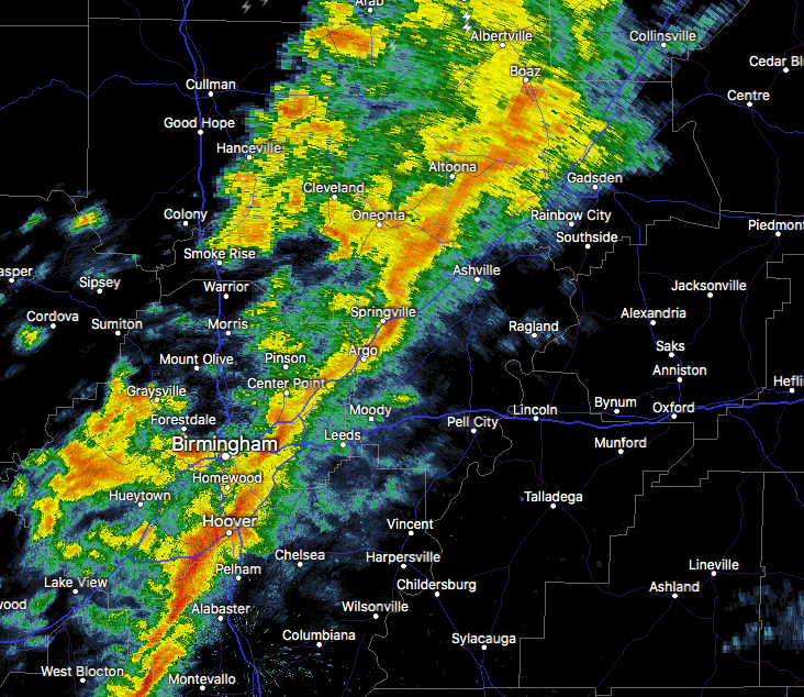
At 925 AM CST, Doppler radar was tracking strong thunderstorms along a line extending from near Altoona to near Clay. Movement was east northeast at 45 mph. Winds in excess of 40 mph will be possible with these storms.
Locations impacted include…
Gadsden, Rainbow City, Boaz, Attalla, Springville, Odenville, Glencoe, Margaret, Argo, Ashville, Sardis City, Ragland, Steele, Altoona, Walnut Grove, Reece City, Tabor Road, Aurora, Branchville and Gadsden Mall.
Category: Alabama's Weather, ALL POSTS
About the Author (Author Profile)
Scott Martin is an operational meteorologist, professional graphic artist, musician, husband, and father. Not only is Scott a member of the National Weather Association, but he is also the Central Alabama Chapter of the NWA president. Scott is also the co-founder of Racecast Weather, which provides forecasts for many racing series across the USA. He also supplies forecasts for the BassMaster Elite Series events including the BassMaster Classic.Subscribe
If you enjoyed this article, subscribe to receive more just like it.


