The Latest Thinking for the Tennessee Valley
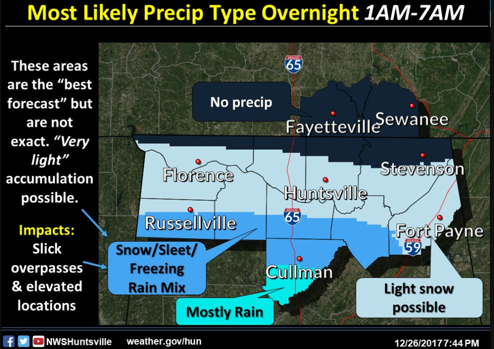
The NWS in Huntsville is not issuing any advisories for their counties in the Tennessee Valley since there is no confidence in accumulations and impacts.
According to them, the narrow area will be along the southern portion of their forecast area, but all south of the Tennessee River. This graphic explains their thinking.
Here is the text of their Special Weather Statement:
Special Weather Statement
National Weather Service Huntsville AL
918 PM CST Tue Dec 26 2017
ALZ003-004-007-008-010-016-271300-
Franklin AL-Lawrence-Morgan-Marshall-De Kalb-Cullman-
Including the cities of Russellville, Red Bay, Moulton, Town Creek,
Decatur, Albertville, Boaz, Guntersville, Arab, Fort Payne,
Rainsville, and Cullman
918 PM CST Tue Dec 26 2017
…Light Wintry Precipitation Possible South of the Tennessee River
After Midnight…
A weak disturbance will bring light precipitation to southern
portions of the Tennessee Valley late tonight into early Wednesday
morning. Surface temperatures at or just below freezing could support
some very light accumulations of sleet, ice, or snow. A few
localized slick spots may develop around daybreak, primarily bridges
and overpasses, and elevated surfaces. Use caution in these areas
late tonight into the Wednesday morning commute. Slow down and allow
extra time to reach your destination.
Category: Alabama's Weather
About the Author (Author Profile)
Bill Murray is the President of The Weather Factory. He is the site's official weather historian and a weekend forecaster. He also anchors the site's severe weather coverage. Bill Murray is the proud holder of National Weather Association Digital Seal #0001 @wxhistorianSubscribe
If you enjoyed this article, subscribe to receive more just like it.


