Bitterly Cold Air Stays In Place Through The Week
HAPPY NEW YEAR! We start 2018 with what most likely will be the coldest air of this winter season. Temperatures over the northern half of Alabama are in the teens at daybreak, and the wind chill index has dropped to zero at Birmingham as of 6:30 a.m. We stay below freezing all day today with a partly to mostly sunny sky; the high will be in the 27-31 degree range for most places across North/Central Alabama.
Up north, Hettinger, ND dropped to -44F (actual air temperature, not a wind chill). That is 16 degrees away from tying the all time coldest temperature ever recorded in North Dakota (-60F at Parshall ND in 1936).
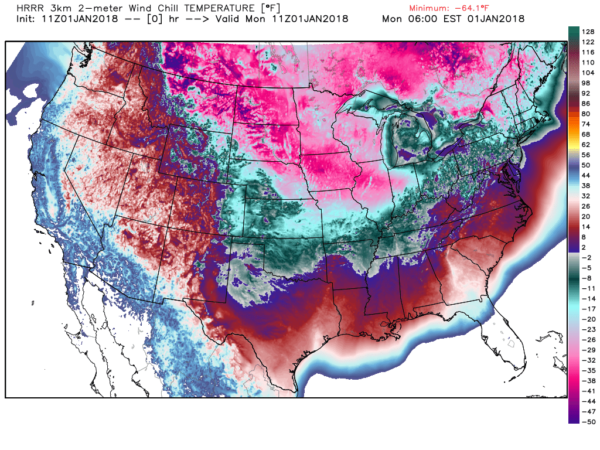
A wind chill advisory and hard freeze warning will remain in effect tonight. The low early tomorrow will drop into the 8-12 degree range, with wind chill indices below zero at times. Check on elderly people and others that might not have an adequate source of heat, bring pets into a warm place, insulate exposed pipes, keep some water dripping, and don’t walk onto frozen ponds.
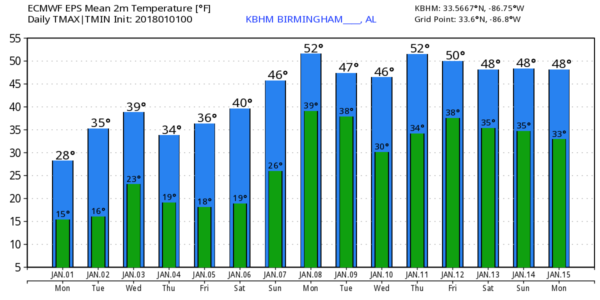
TOMORROW/WEDNESDAY: We stay below freezing tomorrow, and drop back down into the 10-15 degree range early Wednesday morning. Then, we should go above freezing Wednesday afternoon as temperatures rise to near 40 degrees. At Birmingham we have been below freezing since 3pm yesterday, we should hit 33 around 10:00 a.m. Wednesday… that will make for a period of 67 consecutive hours below freezing. That should put it in 7th place in the record book; the record is 116 hours from January 23rd-28th, 1940.
The air stays dry and the sky should be partly to mostly sunny both days.
THURSDAY/FRIDAY: A new surge of Arctic air moves in Thursday. After a low in the mid teens, we won’t get past the mid 30s, and yet another hard freeze is likely early Friday morning with lows between 13 and 16 for most communities across North and Central Alabama. Friday’s high will be in the upper 30s; no risk of any snow or ice as the air stays very dry.
THE ALABAMA WEEKEND: Another morning in the teens early Saturday as the weekend begins, but we should see a high in the 40s Saturday afternoon. Clouds increase Sunday with a high near 50; some rain is possible late in the day or Sunday night with the next wave; global models show it will be warm enough for no winter mischief around here.
NEXT WEEK: Some rain could linger into Monday, the rest of the week looks cold and dry, but not as cold as this week with highs generally in the 40s. See the Weather Xtreme video for maps, graphics, and more details.
BEACH FORECAST: Click here to see the AlabamaWx Beach Forecast Center page. The Beach Forecast is partially underwritten by the support of Brett/Robinson Vacation Rentals in Gulf Shores and Orange Beach. Click here to see Brett/Robinson’s Hot Deals now!
WEATHER BRAINS: Don’t forget you can listen to our weekly 90 minute netcast anytime on the web, or on iTunes. This is the show all about weather featuring many familiar voices, including our meteorologists here at ABC 33/40.
CONNECT: You can find me on all of the major social networks…
Facebook
Twitter
Google Plus
Instagram
Pinterest
Snapchat: spannwx
We are on a holiday schedule, so just one video today, but I will post fresh forecast notes here this afternoon. Enjoy the day and stay warm!
Category: Alabama's Weather, ALL POSTS, Weather Xtreme Videos
About the Author (Author Profile)
James Spann is one of the most recognized and trusted television meteorologists in the industry. He holds the AMS CCM designation and television seals from the AMS and NWA. He is a past winner of the Broadcast Meteorologist of the Year from both professional organizations.Subscribe
If you enjoyed this article, subscribe to receive more just like it.


