Rain Returns Monday; Some Ice Sunday Night??
FRIGID MORNING: Here are some temperatures around the state just before daybreak…
Black Creek 9
Fort Payne 10
Valley Head 10
Russellville 10
Cullman 11
Gadsden 12
Pell City 12
Weaver 13
Sycamore 14
Hueytown 15
Talladega 15
Heflin 15
Anniston 16
Bessemer 16
Jemison 17
Tuscaloosa 19
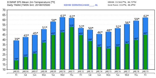
Today will be sunny and cold with a high between 37 and 40 degrees this afternoon. And, another hard freeze is ahead tonight; most places will be in the 15-19 degree range early tomorrow.
THE ALABAMA WEEKEND: The air remains very dry tomorrow; the day will be sunny with a high in the low 40s. Then, on Sunday, with a mix of sun and clouds we reach the upper 40s. Clouds thicken Sunday night.
SLEET/FREEZING RAIN SUNDAY NIGHT? Precipitation begins ahead of the next wave Sunday night, and with evaporative cooling, there is a chance that surface temperatures will be close to freezing late Sunday night and early Monday morning, and we will introduce the risk of a little sleet and freezing rain as it all begins, mainly for areas north and east of Birmingham. For now any impact seems to be very minimal, but we will keep an eye on trends over the weekend.
Some freezing rain is also possible over North Georgia early Monday, and a touch of bridge icing is possible there. For those heading to the NCAA National Championship game, just be aware of the possibility, it will be close call for Atlanta for some bridge icing early Monday. But, he day will just be cold and wet with rain.
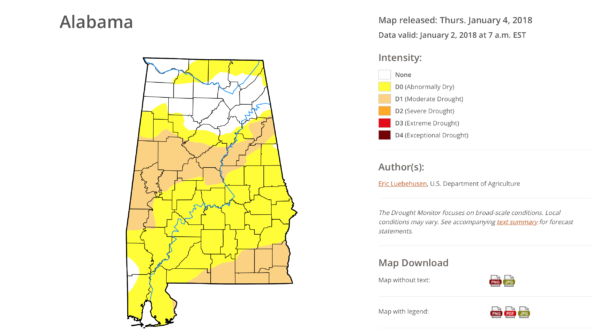
MONDAY IN ALABAMA: A good, soaking rain is likely with a high in the low 50s; rain amounts of around one inch are likely. This is needed rain since the latest Drought Monitor shows parts of Alabama now in drought conditions again.
There is no risk of severe weather Monday, and probably no thunder.
REST OF NEXT WEEK: Tuesday and Wednesday look dry and weather pleasant; we reach the upper 50s Tuesday, and the high Wednesday will be close to 60 degrees as Pacific air covers the region, as opposed to Arctic air. Rain should return by the end of the week… see the Weather Xtreme video for maps, graphics, and more details.
BEACH FORECAST: Click here to see the AlabamaWx Beach Forecast Center page. The Beach Forecast is partially underwritten by the support of Brett/Robinson Vacation Rentals in Gulf Shores and Orange Beach. Click here to see Brett/Robinson’s Hot Deals now!
WEATHER BRAINS: Don’t forget you can listen to our weekly 90 minute netcast anytime on the web, or on iTunes. This is the show all about weather featuring many familiar voices, including our meteorologists here at ABC 33/40.
CONNECT: You can find me on all of the major social networks…
Facebook
Twitter
Google Plus
Instagram
Pinterest
Snapchat: spannwx
Look for the next Weather Xtreme video here by 4:00 this afternoon… enjoy the day!
Category: Alabama's Weather, ALL POSTS, Weather Xtreme Videos
About the Author (Author Profile)
James Spann is one of the most recognized and trusted television meteorologists in the industry. He holds the AMS CCM designation and television seals from the AMS and NWA. He is a past winner of the Broadcast Meteorologist of the Year from both professional organizations.Subscribe
If you enjoyed this article, subscribe to receive more just like it.


