Mild Through Tomorrow; Falling Temps Friday
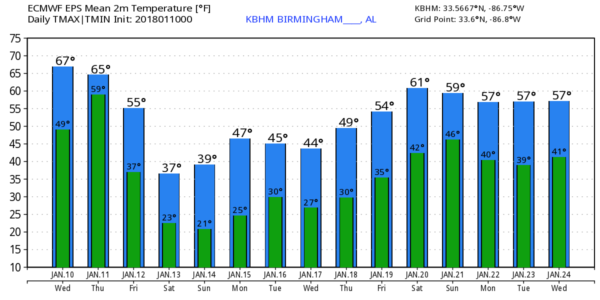
SHORT TERM WARMTH: We project a high in the mid 60s across North/Central Alabama today, about 10 degrees above average for January 10. The sky will be mostly cloudy, but any showers should be few and far between. Upper 60s are possible tomorrow with a few passing showers likely as our thaw continues, but don’t get used to the mild weather.
Rain becomes widespread across the state after midnight tomorrow night and Friday as a cold front pushes through, and temperatures on Friday will fall from the 50s early in the day, through the 40s during the morning hours, and into the 30s by afternoon. Rain amounts of 1/2 to 1 inch are likely.
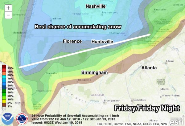
NORTH ALABAMA SNOW? There is a good chance rain will change to snow, possibly mixed with some sleet and freezing rain, over the northern third of Alabama Friday as the cold air rushes into the state. This is the current thinking…
*The chance from rain to wintry precipitation should begin over the northwest corner of the state between 9:00 a.m. and 12:00 noon; that transition line should move steadily eastward during the midday hours.
*The best chance of accumulating snow, for now, seems to be along and north of the Tennessee River of far North Alabama. A few snow flakes or ice pellets are possible as far south as Fayette, Jasper, Oneonta, and Gadsden, but accumulation in those cities seems unlikely.
*Snow amounts of 1 to 3 inches are possible near the Tennessee border for cities like Muscle Shoals, Athens, and Huntsville. With temperatures falling into the 20s by late afternoon, this could bring some travel impact there.
*Accumulating snow is likely northward into Tennessee and Kentucky as well; be aware of that if you are traveling north Friday or Friday night.
*This forecast can, and probably will change, so be sure you are working with fresh information.
BACK INTO THE DEEP FREEZE: The weekend will be cold and dry. Saturday will be partly sunny with a high between 37 and 40 degrees, and we will see sunshine in full force Sunday… Sunday’s high will be close to 40. The low early Sunday morning will be somewhere between 18 and 23 for most communities around here.
NEXT WEEK: Cold air will stay in place; in fact a clipper type system will bring a secondary push of Arctic air by Tuesday and Wednesday. We note the European global model hints at some light snow over North Alabama Wednesday, but the GFS is dry and we will leave the forecast dry for now. We warm up late in the week with some risk of showers by Friday January 20 or Saturday January 21. See the Weather Xtreme video for maps, graphics, and more details.
BEACH FORECAST: Click here to see the AlabamaWx Beach Forecast Center page. The Beach Forecast is partially underwritten by the support of Brett/Robinson Vacation Rentals in Gulf Shores and Orange Beach. Click here to see Brett/Robinson’s Hot Deals now!
WEATHER BRAINS: Don’t forget you can listen to our weekly 90 minute netcast anytime on the web, or on iTunes. This is the show all about weather featuring many familiar voices, including our meteorologists here at ABC 33/40.
CONNECT: You can find me on all of the major social networks…
Facebook
Twitter
Google Plus
Instagram
Pinterest
Snapchat: spannwx
Look for the next Weather Xtreme video here by 4:00 this afternoon… enjoy the day!
Category: Alabama's Weather, ALL POSTS, Weather Xtreme Videos
About the Author (Author Profile)
James Spann is one of the most recognized and trusted television meteorologists in the industry. He holds the AMS CCM designation and television seals from the AMS and NWA. He is a past winner of the Broadcast Meteorologist of the Year from both professional organizations.Subscribe
If you enjoyed this article, subscribe to receive more just like it.


