Back Into The Deep Freeze
TEMPERATURES ARE PLUNGING: As I write this update around 6:30 this morning, the Arctic front is near I-65… to the west temperatures have dropped into the 30s with a strong northwest wind, but East Alabama is mostly in the low 60s. Rain showers continue in many places; they will end later this morning.
Temperatures will continue to fall through the day; Northwest Alabama will wind up in the 20s this afternoon, and a strong northwest wind of 15-25 mph will make it feel colder. A wind advisory is in effect for much of the state.
WINTER WEATHER ADVISORY: NWS Huntsville maintains a winter weather advisory for Lauderdale, Colbert, Franklin, Lawrence, Limestone, Madison, and Jackson counties of far North Alabama today…
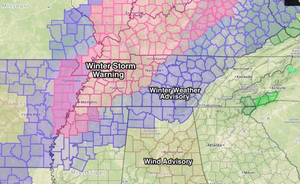
A light wintry mix of snow, sleet, and freezing rain will bring potential for icy travel to this part of the state through tonight.
*If you are traveling north of Alabama, note winter storm warnings are in effect over Tennessee from just west of Nashville to Memphis; this is where 1-3 inches of snow is possible. Winter weather advisories are in effect in Tennessee for Nashville and points east. Wintry precipitation for places like Knoxville and Gatlinburg should be light.
*Snow flurries, or a few ice pellets, are possible today as far south as Tuscaloosa, Birmingham, and Anniston… but there will be no impact.
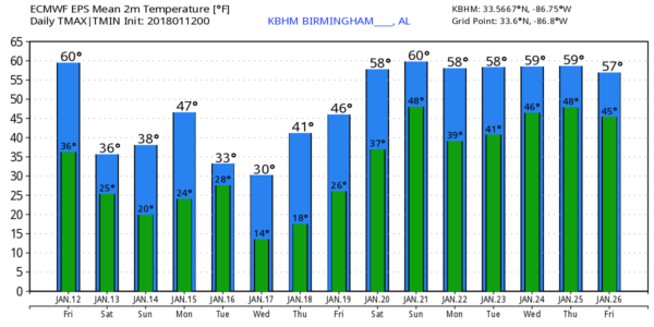
*Very cold air stays in place over the weekend; the sky becomes partly sunny tomorrow, and Sunday will feature sunshine in full supply. Highs will be in the 35-40 degree range, and most North/Central Alabama communities will dip into the upper teens early Sunday morning.
NEXT WEEK: An “Alberta Clipper” will drop in here Tuesday, pulling down even colder air, and potentially bringing a few snow flakes to the state. Traditionally, clippers are starved for moisture and don’t produce much in the way of wintry precipitation. We do note the European global model is a bit aggressive and suggests some chance of accumulating snow over North Alabama, but for now we will discount that solution and just mention a chance of snow flurries Tuesday. We will have plenty of time to watch model trends over the weekend and make adjustments if needed.
Very cold air will cover Alabama Tuesday and Wednesday… we will struggle to climb above freezing both days, and the GFS is printing a low of 12 for Birmingham early Wednesday… and 14 early Thursday. A warming trend begins Friday with a high close to 50, and the next chance of rain seem to be around Sunday January 21. See the Weather Xtreme video for maps, graphics, and more details.
ON THIS DATE IN 1982: A horrible ice storm started across much of Alabama… The event started about 8 hours sooner than forecast… thousands were sheltered, and hundreds of cars were abandoned on Birmingham highways. One suburban shopping mall became a huge shelter. So many wrecks occurred that the Birmingham Police Department could not answer the calls for accident investigation.
As temperatures hovered near the freezing mark through the night of January 12, 1982, freezing rain created a thick coating on all exposed objects. Trees snapped, pulling down power lines and putting as many as 750,000 Alabamians in the dark. The sound of tree limbs snapping under the weight of the ice was like shotguns.
An upper level disturbance brought a nice snowfall the following night that led to some great sledding and snowball fights. But when it was all said and done, twenty Alabamians were dead and another 300 injured and damage totaled $78 million.
BEACH FORECAST: Click here to see the AlabamaWx Beach Forecast Center page. The Beach Forecast is partially underwritten by the support of Brett/Robinson Vacation Rentals in Gulf Shores and Orange Beach. Click here to see Brett/Robinson’s Hot Deals now!
WEATHER BRAINS: Don’t forget you can listen to our weekly 90 minute netcast anytime on the web, or on iTunes. This is the show all about weather featuring many familiar voices, including our meteorologists here at ABC 33/40.
CONNECT: You can find me on all of the major social networks…
Facebook
Twitter
Google Plus
Instagram
Pinterest
Snapchat: spannwx
I have a weather program this morning at Hemphill Elementary in Birmingham… look for the next Weather Xtreme video here by 4:00 this afternoon. Enjoy the day!
Category: Alabama's Weather, ALL POSTS, Weather Xtreme Videos
About the Author (Author Profile)
James Spann is one of the most recognized and trusted television meteorologists in the industry. He holds the AMS CCM designation and television seals from the AMS and NWA. He is a past winner of the Broadcast Meteorologist of the Year from both professional organizations.Subscribe
If you enjoyed this article, subscribe to receive more just like it.


