Winter Storm Watch Tomorrow
DRY, WARMER TODAY: Before we get into the specifics about the snow situation for Alabama tomorrow, today will be a mostly sunny day with a warmer afternoon; we project a high around 50 degrees. This actually could be a bad thing; the pavement/asphalt surfaces will retain some of this heat, leading to a potential problem tomorrow. Snow will fall on the warmer surfaces tomorrow, leading to melting, but with very cold air in place tomorrow (we will be in the 20s most of the day), we could see a “flash freeze” type situation that could put down a thin base of ice on road surfaces.
WINTER STORM POTENTIAL TOMORROW: There is a winter weather advisory in effect for counties served by the National Weather Service office in Huntsville, and a winter storm watch to the south for North/Central Alabama, including Birmingham, Tuscaloosa, Anniston, and Gadsden.
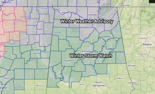
For now, the U.S. 80 corridor (Demopolis to Selma to Montgomery to Opelika) is not in the watch since only trace snow amounts are forecast, but I would still keep an eye on the forecast for any potential changes later today or tonight.
A few snow flurries are possible over South Alabama late tomorrow night and early Wednesday morning.
TIMING: Snow will begin over Northwest Alabama tomorrow morning between 6 and 10am; the onset for Birmingham, Anniston, Gadsden, and Tuscaloosa will be most likely during the afternoon.
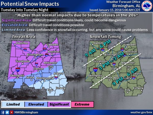
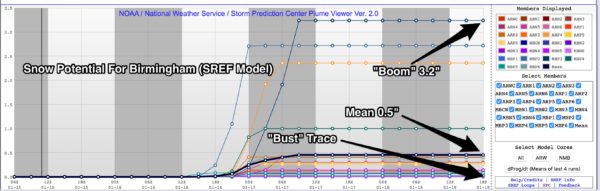
AMOUNTS: Understand snow amounts are expected to be light with this event, generally under two inches. Most places will see 1″ or less. Using the SREF ensemble, the range is from a “boom” value of 3.2″ to a “bust” value of a trace, or nothing more than flurries (which is always possible). The mean value is 1/2″ for Birmingham.
IMPACT: Despite the light snow amounts, as discussed above, there could be major impact. The snow will fall in the wake of an Arctic front, which will drop temperatures into the 20s over North Alabama. The ice accretion process on roads is quiet different in very cold air, and we could see some melting, followed by a quick freeze leading to ice and very hazardous travel. Understand road conditions could deteriorate very quickly as the snow begins to fall tomorrow. I don’t expect much improvement tomorrow night into Wednesday morning, when temperatures drop into the 10-15 degree range.
On the positive side, we expect no power outages.
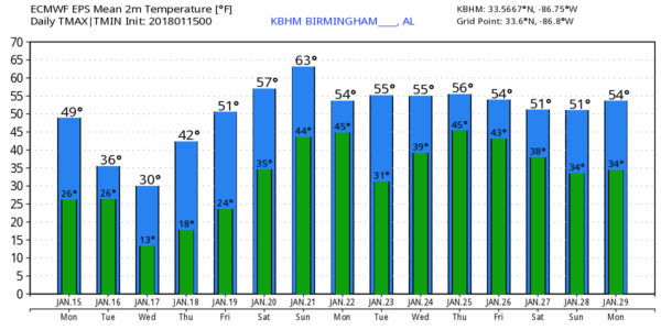
WHEN WILL ROADS IMPROVE? We expect sunshine in full force Wednesday with a high between 30 and 35. Some sublimation/evaporation should help to improve travel by Wednesday afternoon, but icy spots are still possible. Wednesday night will be cold again; we drop into the mid teens by early Thursday morning. Then, we rise into the 40s Thursday afternoon with sunny sky, and any lingering ice will melt.
CONCERNING TRAVEL: I possess no special knowledge or have skill about forecasting specific road conditions in coming days (our training is in meteorology; we aren’t highway engineers). It all depends on your specific route and risk tolerance, but just understand roads could be very icy and dangerous across North/Central Alabama as the snow begins to fall.
STAY IN TOUCH: Remember, keep an eye on updated forecasts today and tonight as changes are very possible. If you are working with an old forecast, it is bad information.
WARMER DAYS BY THE WEEKEND: We sunshine in full supply, we rise into the 50s Friday, and there is a chance temperatures will reach 60 degrees Saturday afternoon as the weekend begins with a partly sunny sky. An approaching cold front will bring a chance of showers and thunderstorms Sunday and Sunday night; we might even have a few strong storms involved. Then, cooler air returns early next week with highs in the 50s, but nothing like the cold air coming in here tomorrow.
See the Weather Xtreme video for maps, graphics, and more details.
BEACH FORECAST: Click here to see the AlabamaWx Beach Forecast Center page. The Beach Forecast is partially underwritten by the support of Brett/Robinson Vacation Rentals in Gulf Shores and Orange Beach. Click here to see Brett/Robinson’s Hot Deals now!
WEATHER BRAINS: Don’t forget you can listen to our weekly 90 minute netcast anytime on the web, or on iTunes. This is the show all about weather featuring many familiar voices, including our meteorologists here at ABC 33/40.
CONNECT: You can find me on all of the major social networks…
Facebook
Twitter
Google Plus
Instagram
Pinterest
Snapchat: spannwx
Look for the next Weather Xtreme video here by 4:00 this afternoon… enjoy the day!
Category: Alabama's Weather, ALL POSTS, Weather Xtreme Videos
About the Author (Author Profile)
James Spann is one of the most recognized and trusted television meteorologists in the industry. He holds the AMS CCM designation and television seals from the AMS and NWA. He is a past winner of the Broadcast Meteorologist of the Year from both professional organizations.Subscribe
If you enjoyed this article, subscribe to receive more just like it.


