Beautiful But Still Rather Cool At Midday, But Snow Is Coming Tomorrow
CONDITIONS OUT THERE AT 12:00 PM
At this point of Martin Luther King, Jr. day in Central Alabama, skies are cloudless and temperatures are warmer than this time yesterday. Temperatures are curring running from the mid-40s in the north to the lower 50s to the south. Birmingham was at 48 degrees, while the warm spots were Tuscaloosa and Troy at 52 degrees. The cool spot was Cullman at 44 degrees.
WEATHER FOR THE REST OF YOUR MONDAY
We’ll continue to have mainly sunny skies throughout the remainder of the daylight hours with afternoon highs reaching the upper 40s to the lower 50s. For this evening and into the overnight hours, skies will remain clear for much of the area, but clouds will be moving in the northwestern parts of Central Alabama as the cold front begins to move in during the pre-dawn hours on Tuesday. Overnight lows will be in the mid-20s to the lower 30s. Maybe a few flurries begin to fall before sunrise in the northwest, but the rest of us will see the snow well into the morning on Tuesday.
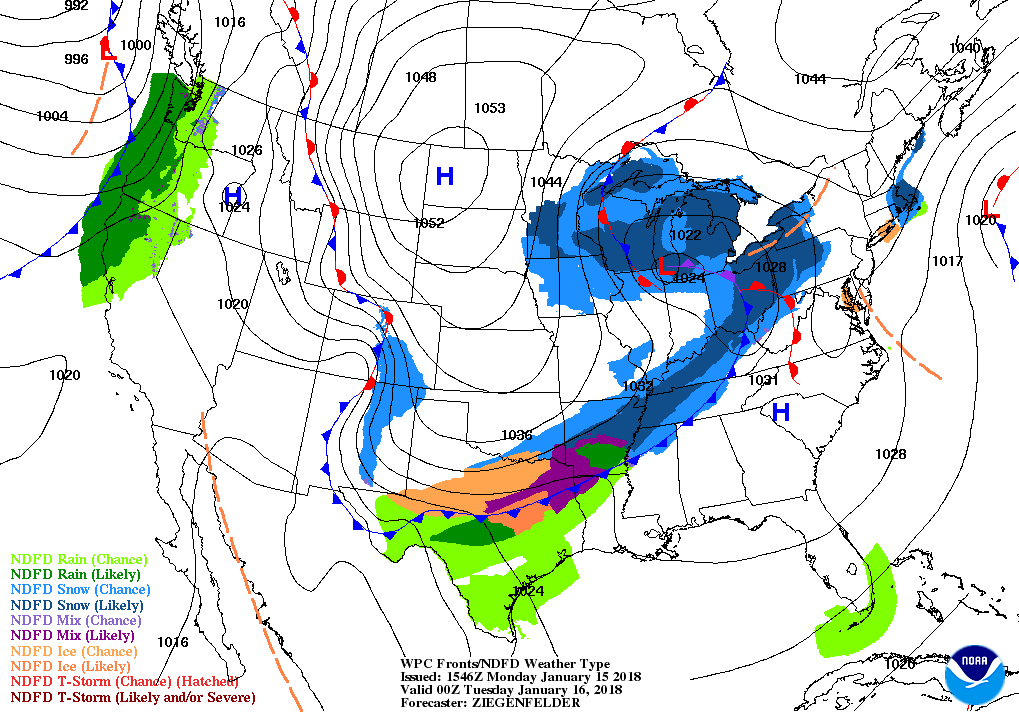
TUESDAY IS A SNOW DAY FOR CENTRAL ALABAMA
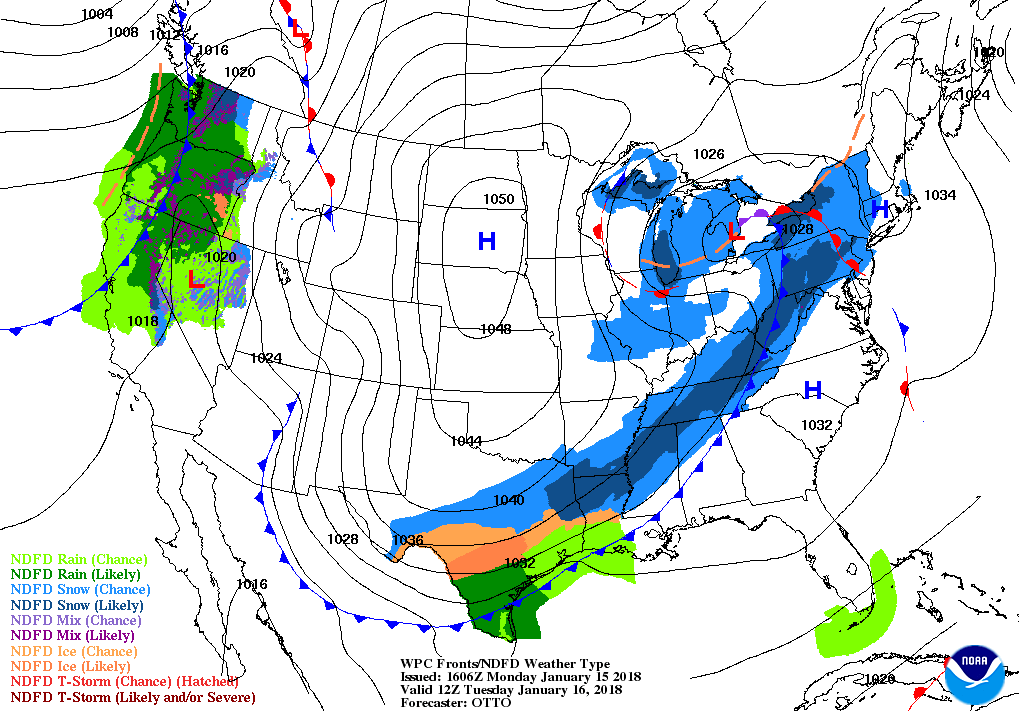
The cold front will have made it to the Birmingham metropolitan area by Sunrise, but the snowfall will be lagging behind the front. Models have really slowed the forward progress of the snow, and if this turns out to be true, more moisture could possibly be pulled into the system.
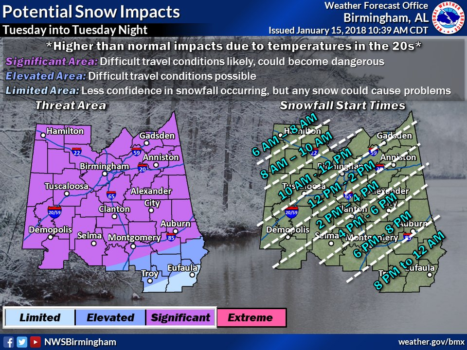
The timing for the main snowfall to start in the northwest will be around the 6AM-8AM time frame, reaching the Birmingham area by 10AM-12PM, and the southeast by 4PM-6PM. Snowfall amounts at this time do not look to be impressive at this time, with a dusting in the southern parts of the area to a possible 1.0-1.5 inches in the northern parts. As I mentioned earlier, if more moisture is pulled into the system, we’ll have to up those totals a little bit. We still have to wait and see on that at this hour.
The main issue will be the dropping temperatures that will allow for major icing issues throughout at least the northern half of the state, but maybe as far south as Montgomery, Troy, and Eufaula. High temperatures will come at different times, topping out in the upper 20s in the northwest to the lower 50s in the southeast. By the 3:00 PM hour, temperatures north of the I-59 and I-20/59 corridors will be below freezing in the 25-30 degree range. Those temperatures will continue to plummet ranging from the upper teens in the northwest to the freezing mark all of the way down to the I-85 corridor in the southeast. Overnight lows will bottom out in the lower teens to the lower 20s, and could actually be a few degrees colder if there is snow cover on the ground. The bigger story will be wind chills will range from near 0 degrees to the mid-teens from north to south, with winds averaging 5-15 MPH out of the north.
While road temperatures will be mostly above freezing to start with, those temperatures will quickly start dropping during the early afternoon. Any melting that occurred earlier could possibly flash freeze and cause widespread icing issues on all surfaces, even with the limited moisture associated with this event. I am no road expert, but I believe road conditions will deteriorate rather quickly once the snow starts falling decently. No need to take a chance on getting stuck out on the road somewhere.
SCHOOL CLOSINGS FOR TUESDAY
Bevill State Community College
Jasper City Schools
Walker County Schools
Winston County Schools
For the latest on closings and delays, please visit the ABC 33/40 Closings page by clicking here.
WATCHES & ADVISORIES ALREADY IN EFFECT FOR TUESDAY & WEDNESDAY
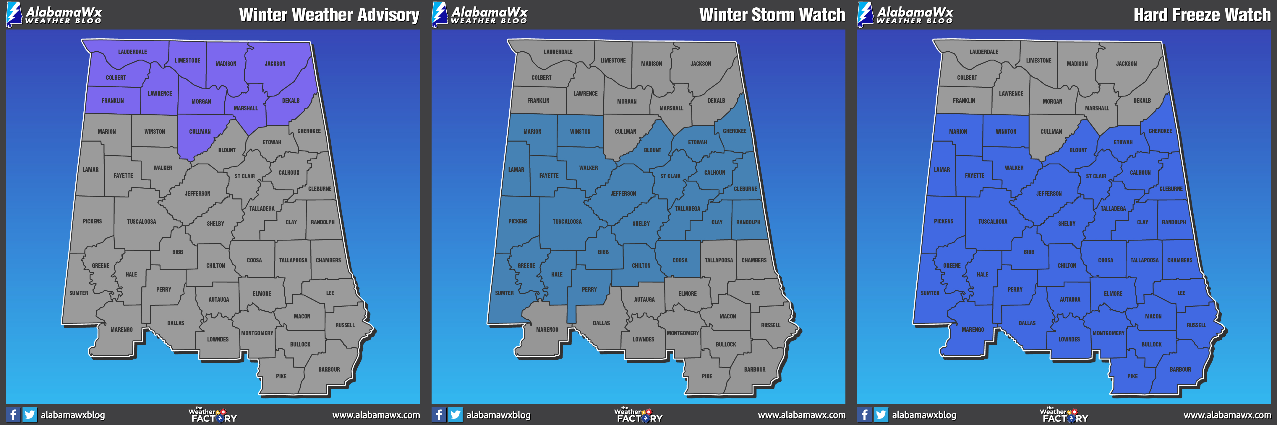
WINTER WEATHER ADVISORY
3:00 AM Tuesday to 6:00 PM Tuesday for Lauderdale, Colbert, & Franklin counties.
6:00 AM Tuesday to 9:00 PM Tuesday for Madison, Morgan, Marshall, Jackson, DeKalb, & Cullman counties.
Light snow expected. Plan on slippery road conditions, including during the morning commute on Tuesday. Total snow accumulations of up to one inch are expected.
WINTER STORM WATCH
6:00 AM Tuesday to 3:00 AM Wednesday for Marion, Lamar, Fayette, Winston, Walker, Blount, Etowah, Calhoun, Cherokee, Cleburne, Pickens, Tuscaloosa, Jefferson, Shelby, St. Clair, Talladega, Clay, Randolph, Sumter, Greene, Hale, Perry, Bibb, Chilton, & Coosa counties.
Accumulating light to moderate snow. Plan on difficult travel conditions, including during the evening commute on Tuesday. Total snow accumulations of up to one inch are possible, but isolated higher amounts cannot be ruled out.
HARD FREEZE WATCH
9:00 PM Tuesday to 9:00 AM Wednesday for all of the Central Alabama counties.
A range of 10-24 degrees is expected Wednesday morning. Prolonged exposure to these temperatures could result in exposed water pipes freezing and possibly bursting, as well as killing sensitive vegetation.
JUST A REMINDER…
Please remember the 4-Ps… People, Pets, Plants, and Pipes. The cold air that will be in place can cause damage to plants and property, so be sure you take the proper steps to protect those. Be sure to check on the elderly and make sure they have proper and safe ways of staying warm. Bring those pets indoors as this cold will be harmful or even deadly. It is possible that a Winter Weather Advisory or Winter Storm Warning could be issued for Central Alabama later this afternoon or evening. Keep checking back with us on the blog throughout the day for the latest updates, and follow us on Twitter and Facebook (@AlabamaWxBlog).
ON THIS DAY IN WEATHER HISTORY
1932 – Up to two inches of snow whitened the Los Angeles basin of California. The Los Angeles Civic Center reported an inch of snow, and even the beaches of Santa Monica were whitened with snow, in what proved to be a record snowstorm for Los Angeles.
THE BEACH FORECAST
Click here to see the AlabamaWx Beach Forecast Center page. The Beach Forecast is partially underwritten by the support of Brett/Robinson Vacation Rentals in Gulf Shores and Orange Beach. Click here to see Brett/Robinson’s Off-Season Deals now!
WEATHERBRAINS
Check out the show at www.WeatherBrains.com. You can also subscribe on iTunes. You can watch the show live at live.bigbrainsmedia.com. You will be able to see the show on the James Spann 24×7 weather channel on cable or directly over the air on the dot 2 feed.
E-FORECAST
Get the AlabamaWx Weather Blog’s Seven-Day Forecast delivered directly to your inbox by email twice daily. It is the most detailed weather forecast available in Central Alabama. Subscribe here… It’s free!
ADVERTISE WITH US
Don’t miss out! We can customize a creative, flexible and affordable package that will suit your organization’s needs. Contact Bill Murray at (205) 687-0782.
Category: Alabama's Weather, ALL POSTS
About the Author (Author Profile)
Scott Martin is an operational meteorologist, professional graphic artist, musician, husband, and father. Not only is Scott a member of the National Weather Association, but he is also the Central Alabama Chapter of the NWA president. Scott is also the co-founder of Racecast Weather, which provides forecasts for many racing series across the USA. He also supplies forecasts for the BassMaster Elite Series events including the BassMaster Classic.Subscribe
If you enjoyed this article, subscribe to receive more just like it.


