An Update on the Alabama Weather Situation As J.B. Might Have Done It
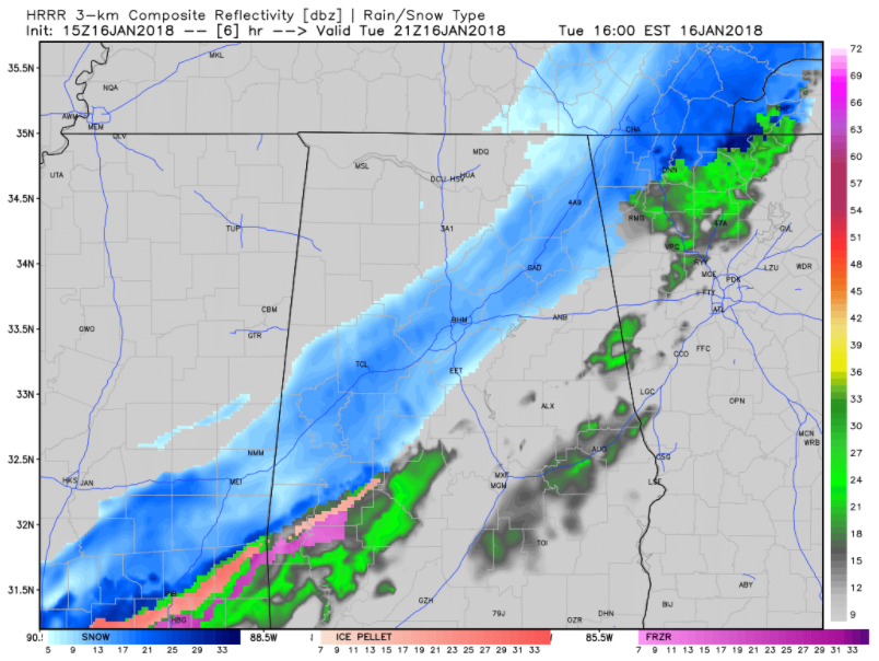
Simulated radar reflectivity from the HRRR model at 3 p.m. CST today showing the snowband in the I-59 corridor.
We are so spoiled now with all the wonderful data that we have. I would have killed for it in the days when all I had was a Weatheradio and Joe Rumore on the Mighty 690 WVOK with his Alabama WeatherWire teletype clattering away in his garage studio.
What would J.B. Elliott have said on that Weatheradio if he were covering today’s winter storm, and not a computer voice?
He might have said:
Here is an update on the Alabama Weather Situation shortly before 11 o’clock.
Snow is falling over the northwestern quarter of the state at this hour. The leading edge extends from Albertville in Marshall County to near Blountsville in Blount County to Warrior in Jefferson Couty then to Berry in Fayette County and Gordo in Pickens County. We have a report of snow flurries in Warrior.
Earlier, there was a report that snow was starting to accumulate on secondary roads at Hackleburg in Maron County. The NWS Huntsville reports that there is a dusting on a few lanes of I-565. Earlier, a multiple vehicle accident was reported at Greenbrier on I-565 but we’re not sure it was weather-related. Alabama DOT trucks pre-treated the roads overnight with a salt solution, but roads will quickly become snow covered and icy, especially with the very cold temperatures.
Temperatures have risen over East Alabama, where there has been a little sun. But don’t let your guard down, temperatures will drop during the afternoon before the snow starts in your area.
The arctic front extends from Mobile to just north of Montgomery to near Heflin at this hour. Temperature readings are currently in the lower and middle 20s across Northwest Alabama, as Arctic air pours into the state. It is 21F at Muscle Shoals, 23F at Decatur and 24F at Huntsville. It is 12F at Memphis, 16F at Oxford, Mississippi, and 18F at Tupelo.
Some reports from Mississippi:
…the NWS in Jackson reports that the Flyover at the Stack in Jackson is beginning to ice over. LIght snow is being reported at the Jackson Airport with 24 degrees this hour.
…1 inch of snow is on the ground at Rolling Fork in the Mississippi Delta. Shaw has 2 inches. Greenville, Mississippi, on US-82 directly west of Birmingham reports 1.5 inches and it was still snowing. One inch of snow is on the ground at Drew in Sunflower County. These locations are all northwest of Jackson in the Delta.
…There is one-half inch of snow on the ground just west of Vicksburg just after 10 a.m.
In Arkansas, 2.5 inches is reported at Hampton, in Calhoun County Arkansas. That’s northeast of El Dorado. 3.5 inches of snow was measured at DeWitt, which is southeast of Little Rock. 4.3 inches of snow was reported at Fordyce, Arkansas.
Five inches of snow is on the ground at Dyersburg, Tennessee.
And an interesting note, the NWS in Little Rock reports that you can actually see lake effect clouds and snow flurries forming off the warm waters of lakes across northern Arkansas and southern Missouri. It is 3 degrees this hour in Branson, Missouri. Earlier it was zero.
Snow continues all the way back into Louisiana and Texas at this hour. There is light snow in Alexandria, Louisiana with 27 degrees. Light freezing rain is being reported at Houston Intercontinental Airport with 30 degrees.
And here is a late report from the NWS Jackson. 3 inches of snow in Rayville LA. Roads are snow covered and I-20 is closed. Rayville is just east of Monroe in North Louisiana.
Two more bands of moderate snow are pushing across northern and Central Mississippi at this hour and will affect North and Central Alabama later. Snow will begin in the Birmingham and Tuscaloosa areas before 1 p.m. with heavier snow it looks like between 2 and 4 p.m. The snow should end in Tuscaloosa around 8 p.m., 9 p.m. in Birmingham and 11 p.m. in Anniston.
Winter weather advisories now cover the entire state of Alabama all the way into the Florida Panhandle, including the beaches of Alabama and Northwest Florida.
We expect that up to 1.5 inches of snow will fall across parts of Central Alabama through this afternoon and evening, with some higher snow totals possible. Travel will become extremely difficult as roads become snow covered and slick.
A hard freeze warning is in effect for tonight along with a wind chill advisory. Readings tonight will drop into the single digits over North Alabama with teens across the rest of Central Alabama. Below zero wind chills will be the rule tonight and early Wednesday. Frostbite and hypothermia can occur, so take precautions. Wear a hat and gloves.
Highs on Wednesday will not get above freezing over the northern half of Alabama, so not much improvement is expected.
All Alabamians should take this winter storm seriously. We will have frequent updates throughout the storm.
Category: ALL POSTS, Winter Weather
About the Author (Author Profile)
Bill Murray is the President of The Weather Factory. He is the site's official weather historian and a weekend forecaster. He also anchors the site's severe weather coverage. Bill Murray is the proud holder of National Weather Association Digital Seal #0001 @wxhistorianSubscribe
If you enjoyed this article, subscribe to receive more just like it.


