Warming Kicks In; Wet Monday
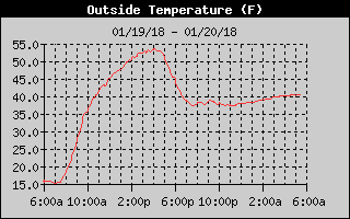
What a difference a day makes! Take a look at the warming that went on overnight from the temperature trace at my weather station in Helena. My low was 15 degrees yesterday morning, but it looks like it will be 39 degrees today. Spectacular!!
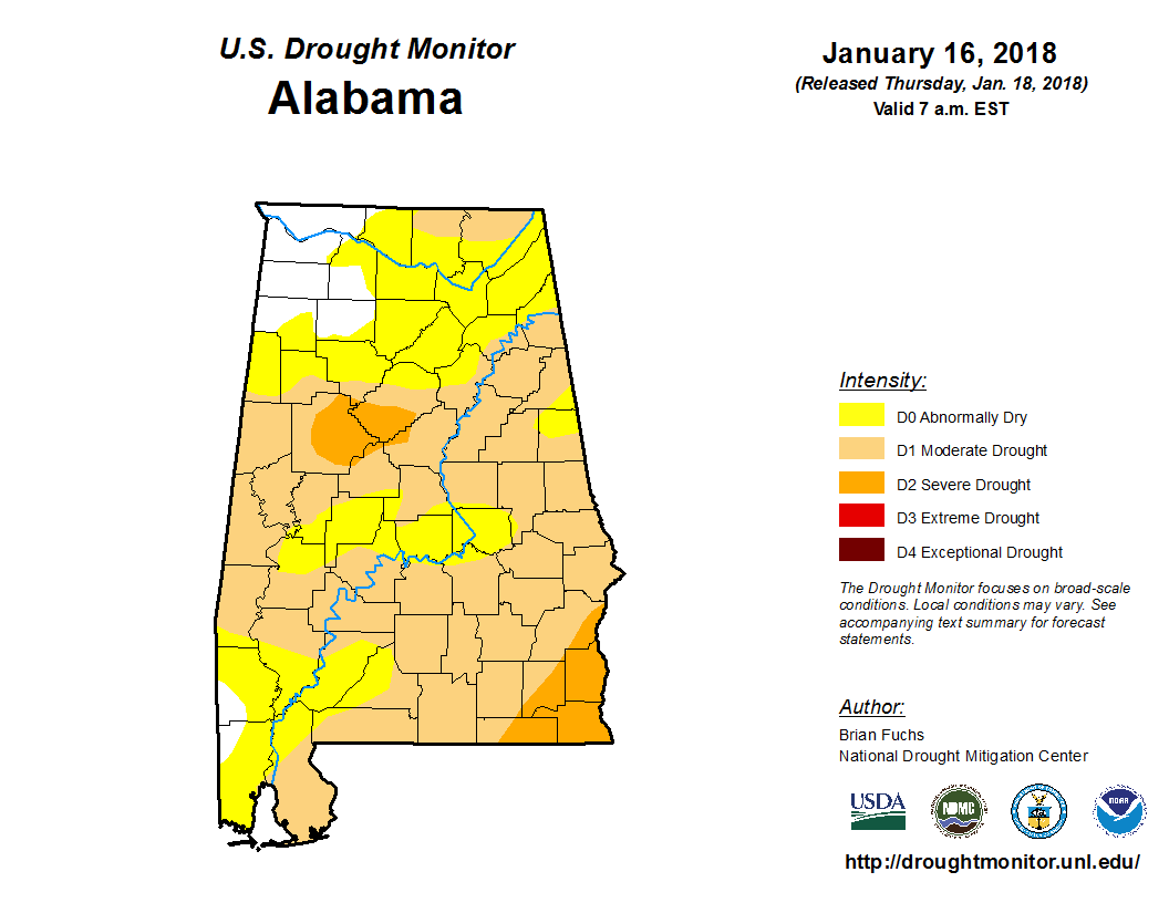
But drought has also raised its ugly head as much of Alabama with the exception of the northwest corner is in some form of drought.
Clouds cover much of the Southeast US though parts of Georgia, South Carolina, and Northeast Florida were clear approaching sunrise. Much of the cloudiness was due to the presence of a weak closed low at 500 millibars over Louisiana. The warming seen at my station was being caused by the surface high pressure center as it moved slowly to our east allowing surface flow over the Lower Mississippi River Valley to come around to the south raising moisture levels to our west. Look for highs today to reach the middle and upper 50s.
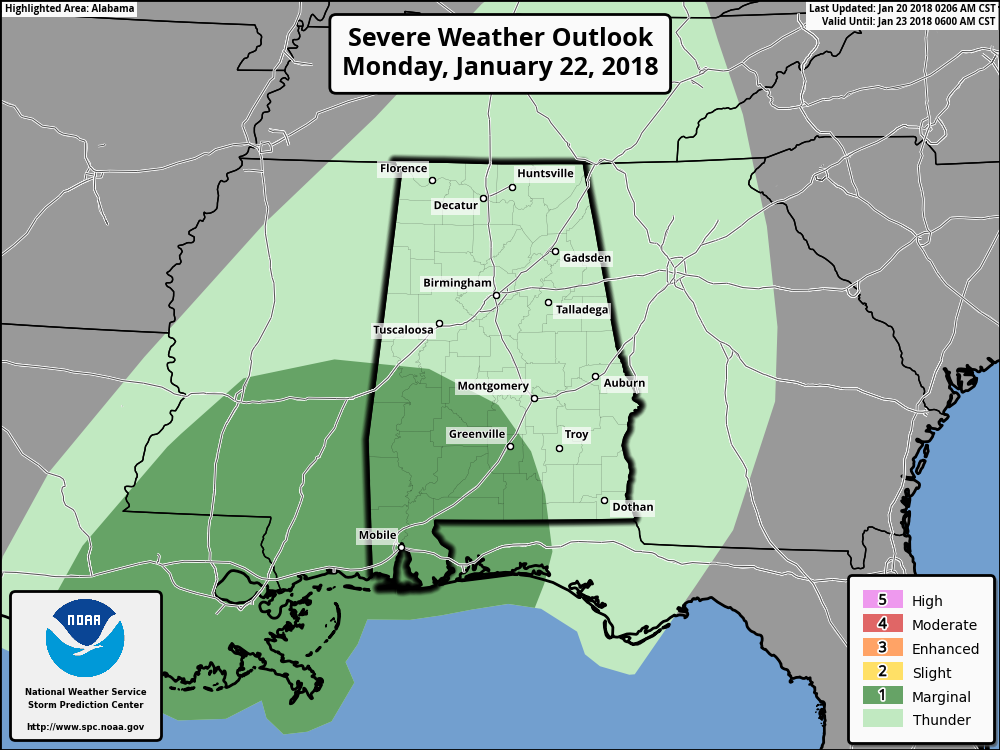
It’s also interesting to note that the SPC outlooks have once again begun to show some marginal risks of severe weather just ahead of a cold front that will be moving through the Southeast US primarily on Monday and early Tuesday. The Day 3 chart showed a marginal risk area covering the southwest section of Alabama where damaging wind is likely to be the primary severe weather threat as the most unstable air remains offshore.
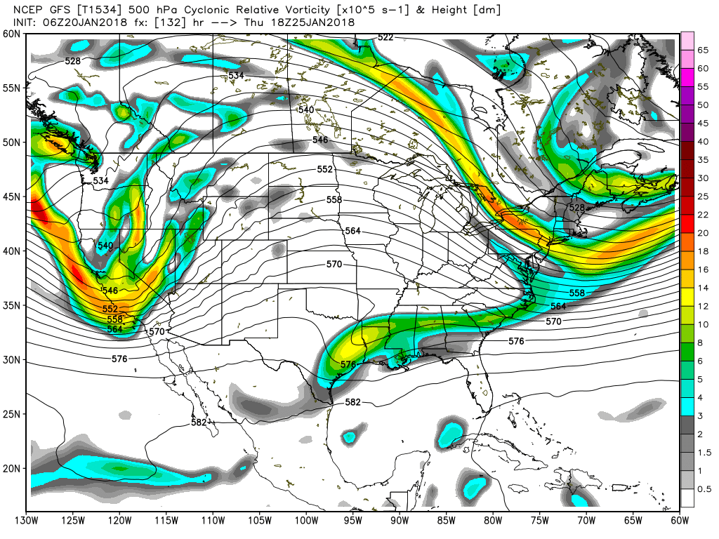
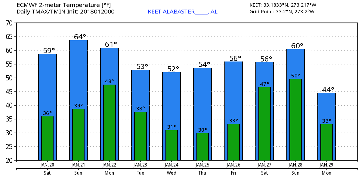
The upper closed low over Louisiana this morning will move off the Southeast US coast on Sunday allowing a ridge to pump up over the Southeast US ahead of a strong trough and closed low coming out of the Four Corners area. This will allow temperatures to warm even further with highs Sunday in the middle 60s.
Monday the upper trough approaches the Mississippi River along with a cold front moving through Mississippi Monday morning. This will generate showers and perhaps a few thunderstorms on Monday with that marginal risk for severe storms in Southwest Alabama where CAPE values will reach near 1000 j/kg. The front should pass through Central Alabama in the afternoon Monday capping our high temperatures in the middle 60s.
The upper air pattern is somewhat nondescript Tuesday through Thursday as a surface high pressure system moves across the Ohio River Valley keeping us cool but not especially cold. I would expect to see lows in the 30s and highs in the 50s, numbers pretty close to seasonal averages for this time in January (54/34 for Birmingham).
A small short wave aloft moves across the Southeast US late Thursday and into Friday, but moisture is pretty sparse so I would expect to see some clouds with highs in the 50s. We’ll have to wait on the next upper air short wave to come our way on Saturday to boost our rain chances for Sunday, though we are verging into voodoo country. The ridge over the Southeast Friday and Saturday should be enough to push highs Saturday into the lower 60s.
Looking into voodoo country, the strong trough carves out another broad trough over the eastern US by Monday knocking our temperatures back into chilly values with highs Monday in the middle 40s. But unlike the recent cold that lingered for a good spell, this cold spell should be very short lived as we come under ridging once again by Wednesday and Thursday, February 1st. And the GFS maintains the ridging pattern into early February, so we should stay relatively warm with values above seasonal averages.
Beach Forecast: Click here to see the AlabamaWx Beach Forecast Center page. The Beach Forecast is partially underwritten by the support of Brett/Robinson Vacation Rentals in Gulf Shores and Orange Beach. Click here to see Brett/Robinson’s Hot Deals now!
WeatherBrains: Don’t forget you can listen to our weekly 90 minute netcast anytime on the web, or on iTunes. This is the show all about weather featuring many familiar voices, including our meteorologists here at ABC 33/40.
Busy weekend as I will be filling in for Charles Daniel today and Sunday on ABC 3340 News. Be sure to tune in for the latest on the forecast. I’m also presenting severe weather safety information for churches at a workshop today sponsored by the Shelby County Sheriff’s office in Columbiana. Over 350 people have signed up for the workshop, so it looks like we’ll have quite a crowd. The next Weather Xtreme Video will posted here by 7 am or so on Sunday. Have a great day and Godspeed.
-Brian-
Category: Alabama's Weather, ALL POSTS, Weather Xtreme Videos
About the Author (Author Profile)
Brian Peters is one of the television meteorologists at ABC3340 in Birmingham and a retired NWS Warning Coordination Meteorologist. He handles the weekend Weather Xtreme Videos and forecast discussion and is the Webmaster for the popular WeatherBrains podcast.Subscribe
If you enjoyed this article, subscribe to receive more just like it.


