Warm Today, Rain Monday
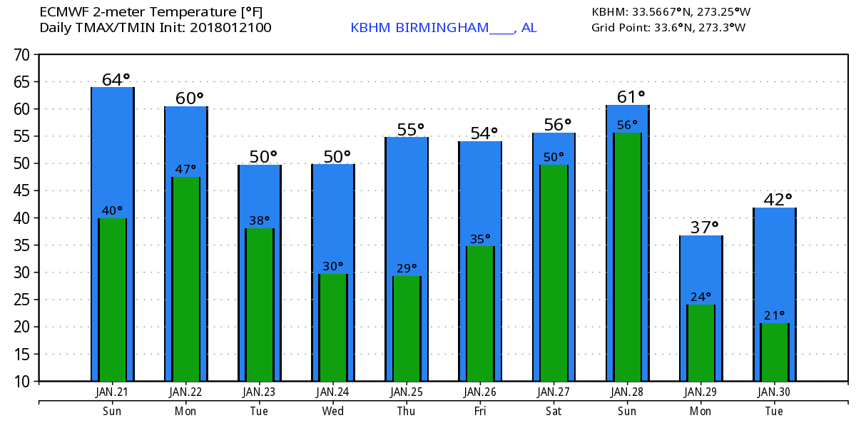
With clear skies overnight temperatures across Central Alabama fell into the middle and upper 30s. If you liked the weather yesterday, I’m pretty sure you are going to love today. The surface high was still positioned just off the Southeast US Coast, so a good southerly flow was helping to keep the weather warm with the highs today in the middle and upper 60s. That southerly flow will continue as a cold front and a fairly strong trough aloft move our direction today and tonight.
The front will move through the Southeast US on Monday. SPC has expanded the marginal risk area ahead of the front as modest instability is likely for much of Alabama with daytime heating. The primary threat appears to be that of damaging thunderstorm wind. Dew points climb into the 50s and highs Monday should be similar to today. Clouds will definitely be in place, and these may limit the amount of near surface heating.
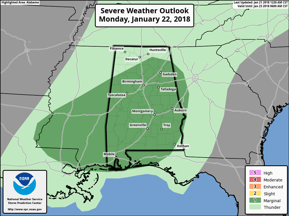
With drought becoming a concern once again, we can certainly use some rain. With the front pushing across Alabama on Monday, it looks like nearly everyone will get some rain with rainfall amounts likely to remain around half an inch. Isolated locations where strong thunderstorms occur could see amounts around three-quarters of an inch.
The strong upper trough moves into the eastern Great Lakes region on Tuesday as the surface front pushes off the Southeast US coast. Temperatures drop about 10 to 12 degrees with highs back in the middle 50s. By Wednesday and Thursday, we come under northwesterly flow aloft which together with the surface high that will be steadily moving across the Southeast US will take our morning lows into the lower 30s. This is still not nearly as cold as some of our previous systems.
By Friday Alabama comes back under the influence of an upper ridge with highs pushing back into the 60s. But the next storm system will begin to take shape to our northwest with a nice trough coming out of the Rockies. A surface low will set up just east of the northern Rockies and move into Southeast Canada by Saturday. The front will drag a trailing cold front across the Lower Mississippi River next Saturday and Sunday bringing a fairly wet system to Alabama. Both the GFS and the ECMWF are in fairly good agreement on this system, so confidence is good that we’ll see a wet day. Instability values appear to remain fairly low, so while there could be some potential for strong to severe storms, we’ll have to wait on future model runs to make a firm determination on that. After the front passes early Sunday and the trough deepens over the eastern US, we’ll see temperatures fall back sharply with highs by Sunday only in the 40s. And Sunday may be one of those days when the temperature falls much of the day.
Looking further afield into week 2 or voodoo country, the deep upper trough over the eastern US on Monday transitions fairly rapidly into a broad ridge by Wednesday, January 31st. The GFS maintains a fairly active flow, but there appears to be no deep systems to bring any extreme cold or extreme warmth to Alabama into the first of February.
Beach Forecast: Click here to see the AlabamaWx Beach Forecast Center page. The Beach Forecast is partially underwritten by the support of Brett/Robinson Vacation Rentals in Gulf Shores and Orange Beach. Click here to see Brett/Robinson’s Hot Deals now!
WeatherBrains: Don’t forget you can listen to our weekly 90 minute netcast anytime on the web, or on iTunes. This is the show all about weather featuring many familiar voices, including our meteorologists here at ABC 33/40.
I’ll be filling in for Charles Daniel once again today, so you can tune into ABC 3340 News at 5 and 10 pm for the latest weather forecast. James Spann will be back with the next Weather Xtreme Video bright and early on Monday morning. Enjoy the lovely, warm day, but get ready for rain on Monday. Enjoy the day and Godspeed.
-Brian-
Category: Alabama's Weather, ALL POSTS, Weather Xtreme Videos
About the Author (Author Profile)
Brian Peters is one of the television meteorologists at ABC3340 in Birmingham and a retired NWS Warning Coordination Meteorologist. He handles the weekend Weather Xtreme Videos and forecast discussion and is the Webmaster for the popular WeatherBrains podcast.Subscribe
If you enjoyed this article, subscribe to receive more just like it.


