A Brief Check On Our Weather Situation Just After 9:00 AM
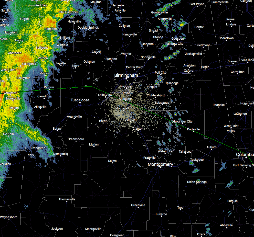
RADAR CHECK AT 9:10 AM
The line of showers and storms is currently moving into the northwestern parts of Central Alabama at this moment, with heavy showers and a few claps of thunder affecting the cities of Hackleburg down to Hamilton and Vernon. The rest of the line is still back off in eastern Mississippi but is slowly moving eastward. No watches or warnings are in effect for Central Alabama at this time.
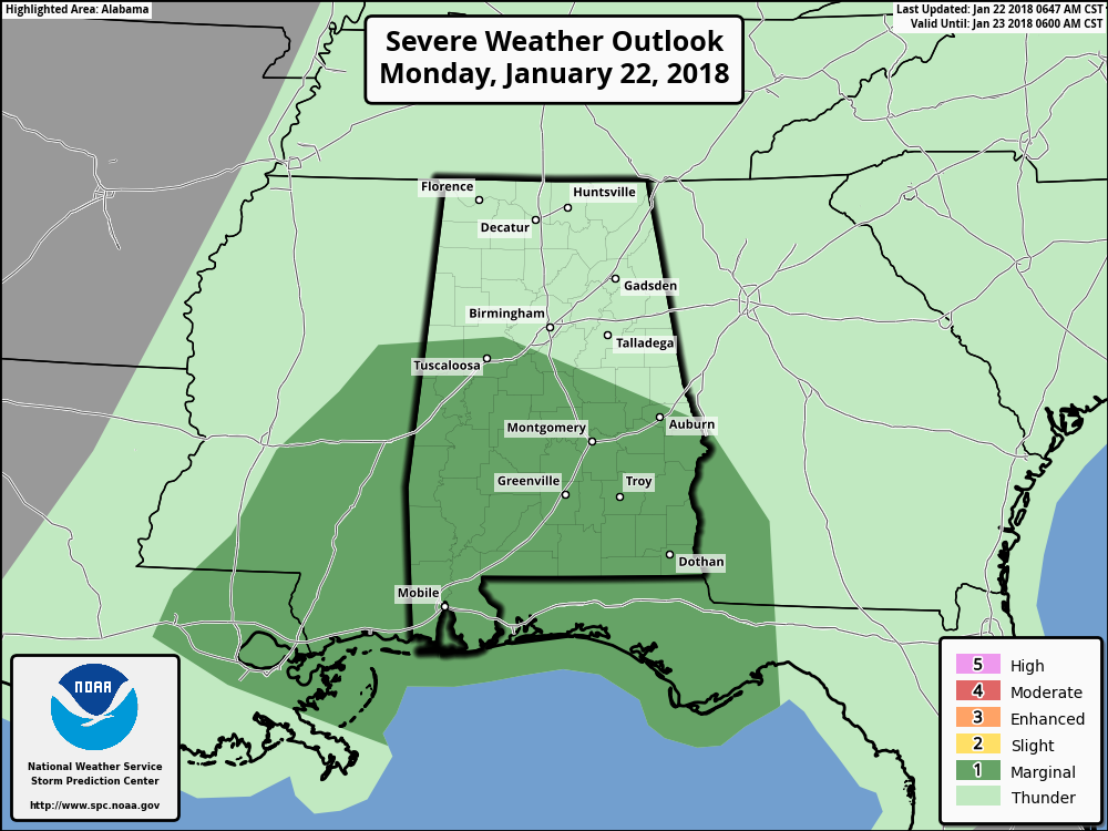
The Storm Prediction Center continues to have the southern-half of Central Alabama in a Marginal Risk for severe storms (south of a line from Reform to Windham Springs to Alabaster to Opelika). The main threat will be from damaging thunderstorm wind gusts up to 60 MPH, with a very small risk of a brief isolated tornado or two.
Timing for the main window of showers and storms throughout the day is a little quicker than first thought… 10:00 AM – 2:00 PM for the western parts of the area (Demopolis, Tuscaloosa, Jasper), 12:00 PM – 4:00 PM for the central parts (Selma, Clanton, Birmingham, Gadsden), and 2:00 PM – 6:00 PM for the eastern parts (Montgomery, Troy, Alexander City, Anniston).
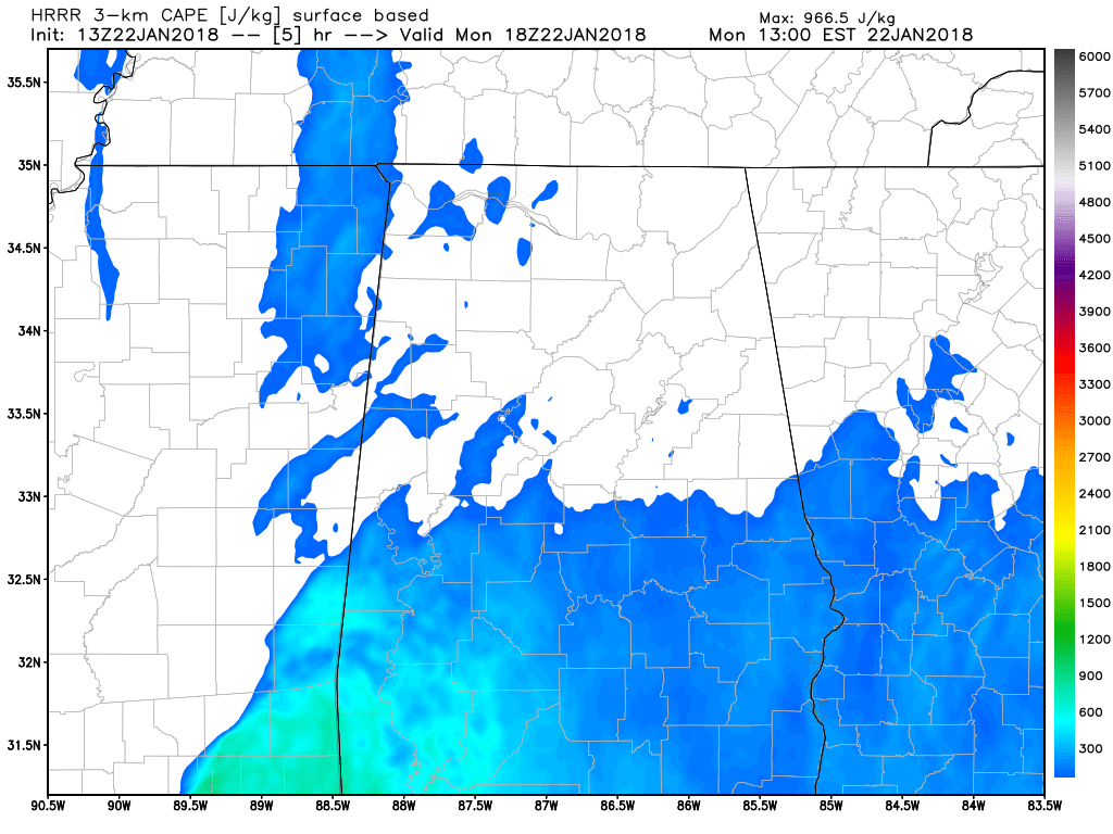
Latest HRRR CAPE values at 12:00 PM today.
Latest HRRR model run for today continues to have the higher threat for strong to severe storms in the southern half of Central Alabama and down into South Alabama. There is no instability showing along and ahead of the main line of storms for the locations along and north of the I-20/59 corridor as it makes its way through the western half of the state and very minimal instability as it moves into the eastern parts. Much of the instability will be south of the I-20 corridor, and even those number will be rather low.
Dewpoints throughout the day will be in the upper 50s in the northern part of the area, with values in the lower 60s throughout the risk area. The magic number to look for with severe weather development with dewpoints is anything over 60 degrees.
There will be a good amount of low-level helicity which would be supportive of rotating updrafts, but the amount of shear over Central Alabama is too high to allow for those updrafts to be sustained. This will keep the risk for tornadoes today very low, but damaging wind gusts up to 60 MPH will be possible in the Marginal Risk area.
We’ll continue to have updates throughout the day on the AlabamaWx Weather Blog at AlabamaWx.com and on our Facebook and Twitter feeds at @AlabamaWxBlog.
Category: Alabama's Weather, ALL POSTS
About the Author (Author Profile)
Scott Martin is an operational meteorologist, professional graphic artist, musician, husband, and father. Not only is Scott a member of the National Weather Association, but he is also the Central Alabama Chapter of the NWA president. Scott is also the co-founder of Racecast Weather, which provides forecasts for many racing series across the USA. He also supplies forecasts for the BassMaster Elite Series events including the BassMaster Classic.Subscribe
If you enjoyed this article, subscribe to receive more just like it.


