Issuance Of A Severe Weather Watch Not likely
Latest NWS SPC Mesoscale Discussion…
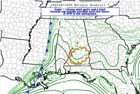
SUMMARY…Storms may pose some risk for locally strong wind gusts and perhaps a brief tornado over southeast Alabama next few hours.
Threat appears too marginal for a weather watch.
DISCUSSION…A cluster of storms with embedded circulations and bowing segments has recently intensified over south-central AL. Activity is forming within corridor of ascent along southern extension of warm conveyor belt. Storms are approaching a minimum in boundary-layer moisture with surface dewpoints around 56 F, and some temporary weakening might occur as a result. However, low-level theta-e advection should contribute to dewpoints rising to near 60F across southeast AL next couple hours, and this should help to sustain surface-based storms next few hours. Effective-bulk shear around 40 kt and 0-1 km storm relative helicity from 200-300 m2/s2 is more than sufficient for transient embedded circulations and bowing segments, but the weak thermodynamic environment is expected to remain the primary limiting factor for a more robust severe threat.
Category: Alabama's Weather, ALL POSTS
About the Author (Author Profile)
Scott Martin is an operational meteorologist, professional graphic artist, musician, husband, and father. Not only is Scott a member of the National Weather Association, but he is also the Central Alabama Chapter of the NWA president. Scott is also the co-founder of Racecast Weather, which provides forecasts for many racing series across the USA. He also supplies forecasts for the BassMaster Elite Series events including the BassMaster Classic.Subscribe
If you enjoyed this article, subscribe to receive more just like it.


