Wet Weather Next Three Days
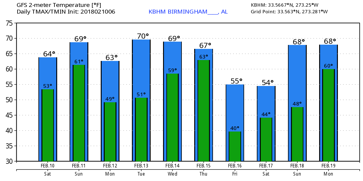
Clouds cover much of the Southeast US, but there are breaks in those clouds in a wide band from New Orleans across the Montgomery area to Atlanta. Fogs also blankets a good deal of the area of South Georgia, North Florida, and a large part of South Carolina. Radar was showing the beginning of the development of storms ahead of a slow moving frontal boundary that stretched from Northeast Texas northeastward to Northwest Pennsylvania with a couple of weak waves along that boundary. We are expected to stay in the warm sector today, so highs should climb well into the 60s.
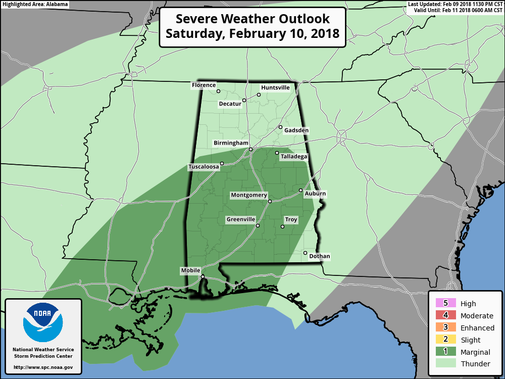
SPC has much of the southern two-thirds of Alabama in a marginal risk today, Day 1. As you’ll see in the video, shear is weak while instability seen in CAPE values is sufficient for the possibility of supercell formation in the warm sector especially during the late morning and the early portion of the afternoon. Damaging wind and the potential for a couple of tornadoes will be the primary risks.
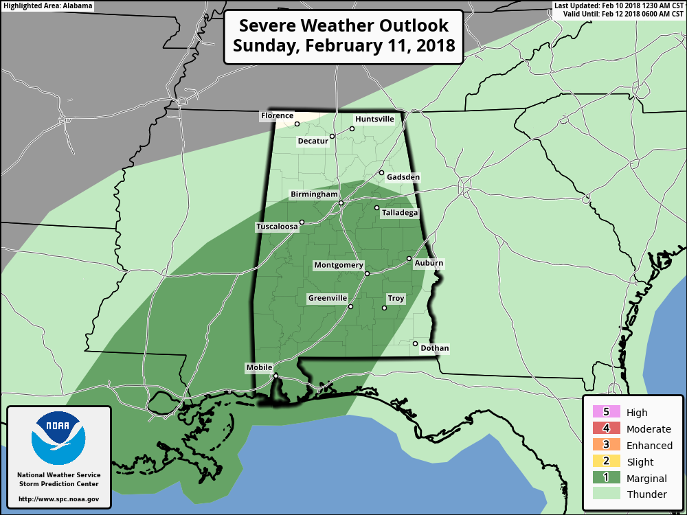
Sunday there will be a similar set up with the frontal boundary still draped across Alabama in the vicinity of Birmingham by midday. With good southwesterly flow aloft, moisture levels will remain very high, so rain chances will be high as well. The instability will be a bit higher on Sunday with the shear values for storm relative helicity low, so the SPC has us in a marginal risk area once again with strong wind gusts and an isolated tornado or two possible.
Monday the upper air pattern remains southwesterly with the upper trough over Nevada and Central California. The frontal boundary has moved further southeast enough that the rain chances should be diminishing across the state from northwest to southeast. With the passage of the slow moving frontal boundary, we will see temperatures drop a little on Monday with highs in the upper 50s.
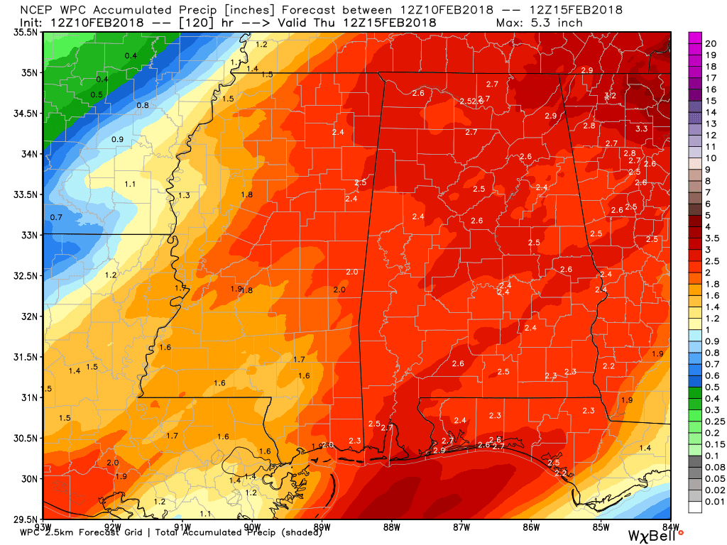
Rain for the next five days appears likely to result in amounts of 2 to 2.5 inches over a fairly large portion of Alabama. This will certainly bring the growing drought conditions to a halt especially with the additional rain we saw this past week.
But the persistent ridge over the Gulf with southwesterly to westerly flow will mean we stay warm with highs around the 70-degree mark from Tuesday to Thursday. Thursday, another front drops into the Southeast US from the northwest meaning another pretty good chance at more rain. While we maintain an upper ridge over the Gulf, the traveling weather systems to the north will push it further south with our highs responding by dropping back into the 60s – still fairly warm for this time of year when our highs should be in the upper 50s for highs and middle 30s for lows.
Looking out into voodoo country, a fairly broad trough becomes the major player around the 19th of February meaning some more chilly weather. The idea of some chilly weather sticks around from the 21st to the 25th with the broad trough once again becoming a major player in the upper air flow pattern.
Beach Forecast: Click here to see the AlabamaWx Beach Forecast Center page.
WeatherBrains: Don’t forget you can listen to our weekly 90 minute netcast anytime on the web, or on iTunes. This is the show all about weather featuring many familiar voices, including our meteorologists here at ABC 33/40.
I enjoyed chatting with folks last night at the World of Wheels at the BJCC. ABC 3340 has a booth there for the show, so if you have a chance, come by and say hello. I’m on the schedule to be there again Sunday afternoon from 2 to 4 pm. I’ll have the next Weather Xtreme Video posted here on Sunday morning. Enjoy the day and stay dry. Godspeed.
-Brian-
Category: Alabama's Weather, ALL POSTS, Weather Xtreme Videos
About the Author (Author Profile)
Brian Peters is one of the television meteorologists at ABC3340 in Birmingham and a retired NWS Warning Coordination Meteorologist. He handles the weekend Weather Xtreme Videos and forecast discussion and is the Webmaster for the popular WeatherBrains podcast.Subscribe
If you enjoyed this article, subscribe to receive more just like it.


