Warmer Days Ahead; A Few Showers
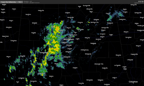
OVERCAST, COLD AFTERNOON: Most guidance from computer models suggested we would reach the 50s today across North/Central Alabama, but that won’t happen as thick clouds and cold air advection combine to keep temperatures in the 40s. A cluster of showers is moving into the Birmingham metro around 3:00 p.m. as I write this update.
Clouds stay in place overnight, and temperatures will pretty much hold where they are now through the night. Any overnight showers will be pretty isolated.
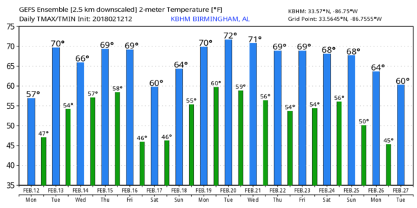
TOMORROW: The sky will remain mostly cloudy; we should rise into the low 60s as the shallow layer of cold air begins to lift out. A shower or two is possible, but not likely.
WEDNESDAY THROUGH FRIDAY: Generally overcast conditions will continue on these three days with mild afternoons, and we will need to mention a chance of showers each day for the northern half of Alabama. The rain won’t be too heavy, but be ready for an occasional shower. Afternoon highs will be mostly in the 60s, although a few spots could bump up into the low 70s, especially south of I-20.
THE ALABAMA WEEKEND: Unfortunately the new GFS run suggests a cold front will stall out over North Alabama Saturday (earlier runs suggested it could make it down to the coast with drier air for us). This means we will have to continue a cloudy forecast for Saturday and Sunday with a risk of showers both days. The rain won’t be as heavy or widespread as what we dealt with this past weekend, but no doubt it should rain at times. Saturday will be a tad cooler with highs in the 50s, but we return to 60s Sunday.
NEXT WEEK: The upper air pattern keeps a long wave upper trough over the western half of the nation next week, keeping Alabama in an unsettled, southwest flow aloft. This means the generally cloudy weather will continue through much of the week, with some risk of showers on just about a daily basis. Highs should be well up in the 60s… see the Weather Xtreme video for maps, graphics, and more details.
No sign of any extended Arctic air blasts, snow, or ice for Alabama through the rest of February.
BEACH FORECAST: Click here to see the AlabamaWx Beach Forecast Center page.
WEATHER BRAINS: Don’t forget you can listen to our weekly 90 minute netcast anytime on the web, or on iTunes. This is the show all about weather featuring many familiar voices, including our meteorologists here at ABC 33/40. We will produce this week’s show tonight at 8:30 CT… you can watch it live here.
CONNECT: You can find me on all of the major social networks…
Facebook
Twitter
Google Plus
Instagram
Pinterest
Snapchat: spannwx
I had a great time today visiting with the kindergarten students today at Alexandria Elementary School… be looking for them on the Pepsi KIDCAM today at 5:00 on ABC 33/40 News! The next Weather Xtreme video will be posted here by 7:00 a.m. tomorrow…
Category: Alabama's Weather, ALL POSTS, Weather Xtreme Videos
About the Author (Author Profile)
James Spann is one of the most recognized and trusted television meteorologists in the industry. He holds the AMS CCM designation and television seals from the AMS and NWA. He is a past winner of the Broadcast Meteorologist of the Year from both professional organizations.Subscribe
If you enjoyed this article, subscribe to receive more just like it.


