

Colder Air For North Alabama; Some Rain At Times
MILD MORNING: Temperatures are in the 60s across Alabama this morning, above the average high of 58 for February 16 at Birmingham. The sky is mostly cloudy, and the radar is quiet.
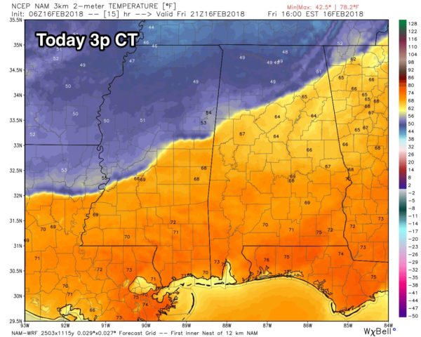
A cold front will enter North Alabama later today, setting up a big thermal contrast across the state. If you are in places like Muscle Shoals, Huntsville, Scottsboro, Hamilton, Haleyville, Cullman, or Fort Payne, temperatures will be falling through the 50s today, potentially winding up in the upper 40s by mid to late afternoon with a north breeze. Tuscaloosa, Birmingham, Anniston, and Gadsden will remain in the 60s through early afternoon, but temperatures will fall into the 50s late in the day as winds veer around to the north.
South of I-20, the day will be mild with afternoon temperatures in the 60s and 70s. Showers are likely over North Alabama later today with the front, but nothing too heavy or really widespread.
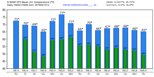
THE ALABAMA WEEKEND: The Tennessee Valley (places like Florence, Athens, Decatur, Huntsville, and Scottsoboro) will be cold and wet tomorrow with temperatures holding in the upper 40s much of the day with occasional showers. To the south, the high will be in the 58-62 degree range for Tuscaloosa, Birmingham, Anniston, and Gadsden, and afternoon temperatures will rise into the low 70s over South Alabama thanks to the upper ridge over the Gulf of Mexico.
The best chance of showers tomorrow will be along and north of I-20 (the northern third of the state)… but even there it won’t rain all day. South of I-20, the southern part of the state will be mostly dry and very mild with highs back in the 60s and low 70s.
Then, on Sunday, the cold air lifts out of North Alabama. The day will feature more clouds than sun with a high in the 60s for the northern counties of the state, with potential for low 70s over South Alabama. We can’t rule out a shower or two Sunday, but they will be pretty widely spaced.
NEXT WEEK: The pattern won’t change much. A strong upper ridge will be over the Gulf of Mexico, nosing up into the southern part of the Gulf Coast states…. and a cold upper trough will be over the western U.S. This means a warm week for Alabama for February; we will be approaching 80 degrees Monday and Tuesday. The high Wednesday will be in the 70s, and then back in the 60s Thursday and Friday. Each day will be mostly cloudy with some risk of showers; the most widespread rain should come Wednesday and Thursday with a front trying to get in here from the north. See the Weather Xtreme video for maps, graphics, and more details.
BEACH FORECAST: Click here to see the AlabamaWx Beach Forecast Center page.
WEATHER BRAINS: Don’t forget you can listen to our weekly 90 minute netcast anytime on the web, or on iTunes. This is the show all about weather featuring many familiar voices, including our meteorologists here at ABC 33/40.
CONNECT: You can find me on all of the major social networks…
Facebook
Twitter
Google Plus
Instagram
Pinterest
Snapchat: spannwx
I have a weather program this morning at Bessemer Academy… look for the next Weather Xtreme video here by 4:00 this afternoon. Enjoy the day!
Category: Alabama's Weather, ALL POSTS, Weather Xtreme Videos
About the Author (Author Profile)
James Spann is one of the most recognized and trusted television meteorologists in the industry. He holds the AMS CCM designation and television seals from the AMS and NWA. He is a past winner of the Broadcast Meteorologist of the Year from both professional organizations.Subscribe
If you enjoyed this article, subscribe to receive more just like it.


