Pattern for Record Warmth
The early morning satellite image showed an abundance of clouds across Central and South Alabama while the Tennessee Valley counties were in the clear with just some thin cirrus clouds. A surface high over the Ohio Valley had helped to settle the front further southward to a position along the Gulf Coast. Temperatures were in the 40s in North Alabama, around 50 in Central Alabama, and in the lower and middle 60s in South Alabama. Showers are forecast once again today – around 30 to 40 percent probabilities – as the front pushes back northward allowing much of Alabama to see highs in the 60s.
Monday the big, warm ridge begins to build northward setting the stage for some serious rain in the Middle Mississippi River Valley and the potential of record break warmth across much of the Southeast US. Here are the record highs from the latest forecast discussion by the NWS in Birmingham.
Location            2/19        2/20        2/21
------------       ------      ------      ------
Birmingham        76(2011)*   78(1986)    78(1922)
Montgomery        83(1891)    80(2011)*   81(2011)
Tuscaloosa        77(2011)*   81(2014)    79(2005)
Anniston          76(2011)*   78(1986)*   75(2011)*
Calera            75(2017)*   76(2017)    75(2011)*
Troy              79(2014)    81(2014)    80(2005)

*Record was set in multiple years, but only the most recent is shown.
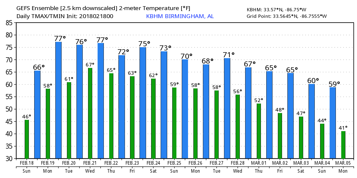
MOS guidance values for Birmingham are 79 on Monday (19th), 84 on Tuesday (20th), and 82 on Wednesday (21st), so the potential for us to see new record values over the next several days is pretty good.
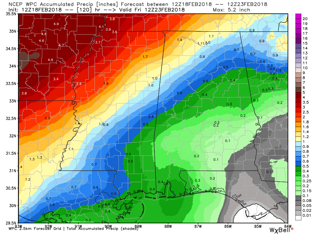
The upper ridge just off the East Coast of Florida pumps up big time along the US East Coast on Monday, Tuesday, and Wednesday. This sets the stage for our highs to rise into record territory, while at the same time keeping the Middle Mississippi River Valley positioned under the moisture flowing out of the Pacific. As you can see from the 5-day forecast for precipitation from the QPF chart, a large swath stretching from Northeast Texas to the Central Great Lakes could see rainfall amounts of 2 to 5 inches through next Friday morning.
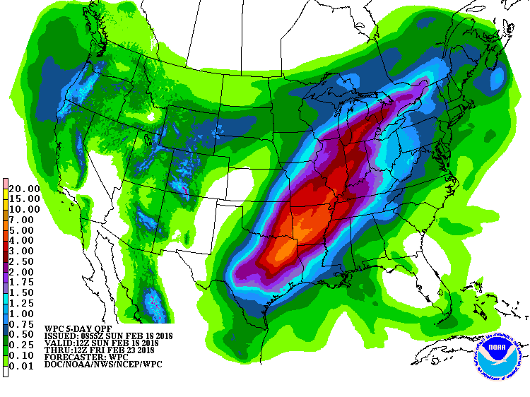
Looking closer at Alabama, there will be a substantial gradient from the northwest corner of the state to the southeast corner with practically northing for Southeast Alabama and around 1.5 inches in Northwest Alabama. Fortunately, over the next three days there does not appear to be any threat for severe weather. Model differences among other issues currently prohibits any kind of certainty for Days 4 and 5 when a front does push into the Southeast US. We’ll need to watch this time frame in later model runs for the potential for a marginal or slight risk.
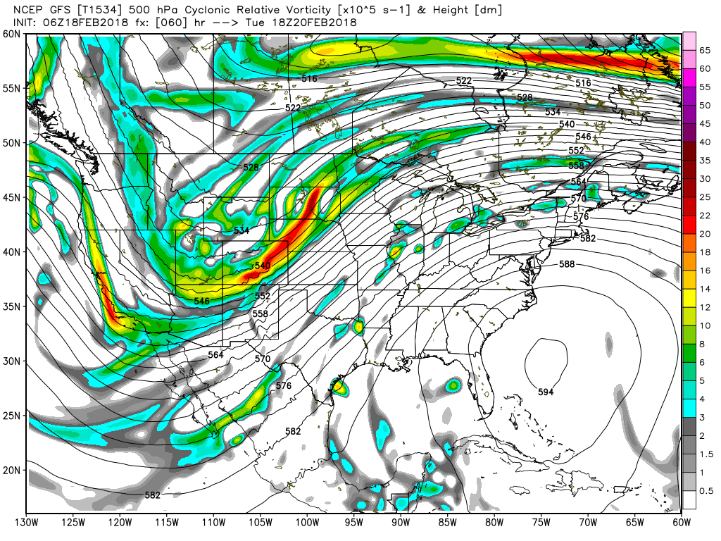
One of the issues is the model difference. The GFS does push the front into the Southeast US while the ECMWF does not push it as far south. It still appears that the best chances for rain for Central Alabama will come Wednesday into Thursday as the front makes its approach. Highs for Monday, Tuesday, and Wednesday will be dancing in the vicinity of 80 degrees, but don’t put those winter coats away just yet – be sure to read the voodoo country paragraph.
The huge ridge for the first half of the week is beaten down the latter half of the week as a strong upper low in the vicinity of the Four Corners Area ejects eastward into the Great Lakes by Saturday. While the ridge weakens, our temperatures will remain warm. Thursday, Friday, and Saturday should see highs in the 70s primarily though the GFS MOS peaks again on Friday with a high in the lower 80s. Not confident with that high since the ridge will be much weaker.
Looking into voodoo country, the ridge remains present on the 27th of February, but a strong upper trough pushes into the Middle Mississippi River Valley around March 2nd. Much to far into the future to make a forecast, but the trough does have a look suggestive of the potential for severe weather. Another ridge moves into the eastern US around the 4th of March, but that’s when the GFS morphs the overall pattern into a deep trough over the eastern third of the country – hence the suggestion to keep winter coats handy.
Beach Forecasts: Click here to see the AlabamaWx Beach Forecast Center page.
WeatherBrains: Don’t forget you can listen to our weekly 90 minute netcast anytime on the web, or on iTunes. This is the show all about weather featuring many familiar voices, including our meteorologists here at ABC 33/40.
I certainly appreciate you viewing the blog. James Spann will be back with the next edition on Monday morning. Perhaps he’ll be doing his weather forecasts in shorts – Bermuda shorts with black socks!! Have a great day, and Godspeed.
-Brian-
Category: Alabama's Weather, ALL POSTS, Weather Xtreme Videos
About the Author (Author Profile)
Brian Peters is one of the television meteorologists at ABC3340 in Birmingham and a retired NWS Warning Coordination Meteorologist. He handles the weekend Weather Xtreme Videos and forecast discussion and is the Webmaster for the popular WeatherBrains podcast.Subscribe
If you enjoyed this article, subscribe to receive more just like it.


